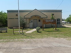
Quemado, Texas

Last updated

Quemado, Texas
CDP
Quemado, TX Library DSCN1440.JPG
The Quemado Library
TXMap-doton-Quemado.PNG
Location of Quemado, Texas
Maverick County Quemada.svg
Coordinates: 28°56′51″N100°37′27″W / 28.94750°N 100.62417°W / 28.94750; -100.62417
Country United States
State Texas
County Maverick
Area
  Total0.1 sq mi (0.3 km2)
  Land0.1 sq mi (0.3 km2)
  Water0.0 sq mi (0.0 km2)
Elevation
[1]
784 ft (239 m)
Population
 (2020)
  Total162
  Density1,600/sq mi (540/km2)
Time zone UTC-6 (Central (CST))
  Summer (DST) UTC-5 (CDT)
ZIP code
78877
Area code 830
FIPS code 48-60092 [2]
GNIS feature ID1365897 [1]

Quemado is a census-designated place (CDP) in Maverick County, Texas, United States. Its population was 230 at the 2010 census.

Contents

Geography

U.S. Post Office on U.S. Route 277 in Quemado U.S. Post Office Quemado, TX DSCN0859.JPG
U.S. Post Office on U.S. Route 277 in Quemado
First Baptist Church of Quemado First Baptist Church, Quemado, TX DSCN1439.JPG
First Baptist Church of Quemado

According to the United States Census Bureau, the CDP has a total area of 64 acres (26 ha), all land.

Demographics

Historical population
CensusPop.Note
2020 162
U.S. Decennial Census [3]
1850–1900 [4] 1910 [5]
1920 [6] 1930 [7] 1940 [8]
1950 [9] 1960 [10] 1970 [11]
1980 [12] 1990 [13] 2000 [14]
2010 [15]

2020 census

Quemado racial composition [16]
(NH = Non-Hispanic) [lower-alpha 1]
RaceNumberPercentage
White (NH)106.17%
Black or African American (NH)10.62%
Mixed/Multi-Racial (NH)21.23%
Hispanic or Latino 14991.98%
Total162

As of the 2020 United States census, there were 162 people, 41 households, and 41 families residing in the CDP.

2000 census

As of the census [2] of 2000, 243 people, 81 households, and 64 families were residing in the CDP. The population density was 2,053.3 people/sq mi (781.9/km2). The 96 housing units averaged 811.2/sq mi (308.9/km2). The racial makeup of the CDP was 53.09% White, 2.47% African American, 42.39% from other races, and 2.06% from two or more races. Hispanics or Latinos of any race were 87.65% of the population.

Of the 81 households, 40.7% had children under the age of 18 living with them, 66.7% were married couples living together, 11.1% had a female householder with no husband present, and 19.8% were not families. About 16.0% of all households were made up of individuals, and 9.9% had someone living alone who was 65 or older. The average household size was 3.00, and the average family size was 3.42.

In the CDP, the age distribution was 28.0% under 18, 7.8% from 18 to 24, 23.9% from 25 to 44, 21.4% from 45 to 64, and 18.9% who were 65 or older. The median age was 38 years. For every 100 females, there were 96.0 males. For every 100 females age 18 and over, there were 94.4 males.

The median income for a household in the CDP was $11,576, and for a family was $11,957. Males had a median income of $11,818 versus $25,000 for females. The per capita income for the CDP was $7,099. About 48.6% of families and 51.7% of the population were below the poverty line, including 50.9% of those under the age of eighteen and 33.3% of those 65 or over.

Education

Quemado is served by the Eagle Pass Independent School District.

Related Research Articles

<span class="mw-page-title-main">Lakehills, Texas</span> CDP in Texas, United States

Lakehills is a census-designated place (CDP) in Bandera County, Texas, United States. The population was 5,295 at the 2020 census, making it the most populous place in Bandera County. It is part of the San Antonio Metropolitan Statistical Area.

<span class="mw-page-title-main">Cross Mountain, Texas</span> Census-designated place in Texas, United States

Cross Mountain is a census-designated place (CDP) in Bexar County, Texas, United States. The population was 3,944 at the 2020 census, an increase over the figure of 3,124 tabulated in 2010. It is part of the San Antonio Metropolitan Statistical Area.

<span class="mw-page-title-main">Scenic Oaks, Texas</span> Census-designated place in Texas, United States

Scenic Oaks is a census-designated place (CDP) in Bexar County, Texas, United States. It is part of the San Antonio Metropolitan Statistical Area. The population was 10,458 at the 2020 census, up from 4,957 at the 2010 census.

<span class="mw-page-title-main">Cameron Park, Texas</span> CDP in Texas, United States

Cameron Park is a census-designated place (CDP) in Cameron County, Texas, United States. The population was 6,099 at the 2020 census. It is part of the Brownsville–Harlingen Metropolitan Statistical Area.

<span class="mw-page-title-main">Agua Dulce, El Paso County, Texas</span> Place in Texas, United States

Agua Dulce is an unincorporated community and census-designated place (CDP) in El Paso County, Texas, United States. The population was 3,218 at the 2020 census. It is part of the El Paso Metropolitan Statistical Area. The ZIP Code encompassing the CDP area is 79928.

<span class="mw-page-title-main">Canutillo, Texas</span> Census-designated place in Texas, United States

Canutillo is a census-designated place (CDP) in El Paso County, Texas, United States. The population was 6,321 at the 2010 census. It is part of the El Paso Metropolitan Statistical Area. The ZIP Codes encompassing the CDP area are 79835 and 79932.

<span class="mw-page-title-main">Homestead Meadows North, Texas</span> Census-designated place in Texas, United States

Homestead Meadows North is a census-designated place (CDP) in El Paso County, Texas, United States. The population was 5,124 at the 2010 census. It is part of the El Paso Metropolitan Statistical Area.

<span class="mw-page-title-main">Homestead Meadows South, Texas</span> Census-designated place in Texas, United States

Homestead Meadows South is a census-designated place (CDP) in El Paso County, Texas, United States. The population was 7,247 at the 2010 census. It is part of the El Paso Metropolitan Statistical Area.

<span class="mw-page-title-main">Redwood, Texas</span> Unincorporated community in Texas, United States

Redwood is an unincorporated community and census-designated place (CDP) in Guadalupe County, Texas, United States. The population was 4,003 at the 2020 census, a decline from the figure of 4,338 tabulated in 2010. It is part of the San Antonio Metropolitan Statistical Area.

<span class="mw-page-title-main">Buna, Texas</span> Census-designated place in Texas, United States

Buna is an unincorporated community and census-designated place (CDP) in Jasper County, Texas, United States. The population was 2,137 at the 2020 census.

<span class="mw-page-title-main">Lipscomb, Texas</span> Census-designated place in Texas, United States

Lipscomb is an unincorporated community and census-designated place (CDP) in Lipscomb County, Texas, United States. It is the Lipscomb county seat. The population was 66 at the 2020 census.

<span class="mw-page-title-main">Eidson Road, Texas</span> CDP in Texas, United States

Eidson Road is a census-designated place (CDP) in Maverick County, Texas, United States. The population was 9,461 at the 2020 census.

<span class="mw-page-title-main">El Indio, Texas</span> Census-designated place in Maverick County, Texas, United States

El Indio is a census-designated place (CDP) in Maverick County, Texas, United States. The population was 263 at the 2000 census.

<span class="mw-page-title-main">Las Lomas, Texas</span> CDP in Texas, United States

Las Lomas is a census-designated place (CDP) in Starr County, Texas, United States. The population was 3,147 at the 2010 census. Las Lomas is one of several colonias in Starr County, within the Rio Grande Valley region. The name is derived from the community's terrain.

<span class="mw-page-title-main">San Isidro, Texas</span> CDP in Texas, United States

San Isidro is a census-designated place (CDP) in Starr County, Texas, United States. The population was 240 at the 2010 census. The town is named for St. Isidore the Laborer, the patron saint of farmers. A large Southwestern Barrel Cactus growing just east of town is said to be the largest in Texas.

<span class="mw-page-title-main">Bloomington, Texas</span> Census-designated place in Texas, United States

Bloomington is a census-designated place (CDP) in Victoria County, Texas, United States. The population was 2,459 at the 2010 census. It is included in the Victoria, Texas Metropolitan Statistical Area.

<span class="mw-page-title-main">Bruni, Texas</span> CDP in Texas, United States

Bruni is a census-designated place (CDP) in Webb County, Texas, United States. The population was 379 at the 2010 census.

<span class="mw-page-title-main">Oilton, Texas</span> CDP in Texas, United States

Oilton is a census-designated place (CDP) in Webb County, Texas, United States. The population was 152 at the 2010 census. The community is within the boundary of Webb Consolidated Independent School District and is home to the Oilton Elementary School.

<span class="mw-page-title-main">Batesville, Texas</span> CDP in Texas, United States

Batesville is a census-designated place (CDP) in Zavala County, Texas, United States. The population was 1,068 at the 2010 census.

<span class="mw-page-title-main">La Pryor, Texas</span> CDP in Texas, United States

La Pryor is a census-designated place (CDP) in Zavala County, Texas, United States. Its population was 1,294 at the 2020 census.

References

  1. 1 2 U.S. Geological Survey Geographic Names Information System: Quemado, Texas
  2. 1 2 "U.S. Census website". United States Census Bureau . Retrieved January 31, 2008.
  3. "Decennial Census by Decade". United States Census Bureau .
  4. "1900 Census of Population - Population of Texas By Counties And Minor Civil Divisions" (PDF). United States Census Bureau .
  5. "1910 Census of Population - Supplement for Texas" (PDF). United States Census Bureau .
  6. "1920 Census of Population - Number of Inhabitants - Texas" (PDF). United States Census Bureau .
  7. "1930 Census of Population - Number of Inhabitants - Texas" (PDF). United States Census Bureau .
  8. "1940 Census of Population - Number of Inhabitants - Texas" (PDF). United States Census Bureau .
  9. "1950 Census of Population - Number of Inhabitants - Texas" (PDF). United States Census Bureau .
  10. "1960 Census of Population - Number of Inhabitants - Texas" (PDF). United States Census Bureau .
  11. "1970 Census of Population - Number of Inhabitants - Texas" (PDF). United States Census Bureau .
  12. "1980 Census of Population - Number of Inhabitants - Texas" (PDF). United States Census Bureau .
  13. "1990 Census of Population - Population and Housing Unit Counts - Texas" (PDF). United States Census Bureau .
  14. "2000 Census of Population - Population and Housing Unit Counts - Texas" (PDF). United States Census Bureau .
  15. "2010 Census of Population - Population and Housing Unit Counts - Texas" (PDF). United States Census Bureau .
  16. "Explore Census Data". data.census.gov. Retrieved May 20, 2022.
  17. https://www.census.gov/ [ not specific enough to verify ]
  18. "About the Hispanic Population and its Origin". www.census.gov. Retrieved May 18, 2022.
  1. Note: the US Census treats Hispanic/Latino as an ethnic category. This table excludes Latinos from the racial categories and assigns them to a separate category. Hispanics/Latinos can be of any race. [17] [18]