
Newquay is a town on the north coast in Cornwall, England, United Kingdom. It is a civil parish, seaside resort, regional centre for aerospace industries with an airport and a spaceport, and a fishing port on the North Atlantic coast of Cornwall, approximately 12 miles (19 km) north of Truro and 20 miles (32 km) west of Bodmin.

Saint Austell is a town in Cornwall, England, United Kingdom, 10 miles (16 km) south of Bodmin and 30 miles (48 km) west of the border with Devon.

The Lappa Valley Railway is a 15 in minimum gauge railway located near Newquay in Cornwall. The railway functions as a tourist attraction, running from Benny Halt to East Wheal Rose, where there is a leisure area with two miniature railways.

The Atlantic Coast Line is a 20+3⁄4-mile (33 km) Network Rail branch line which includes a community railway service in Cornwall, England. The line runs from the English Channel at Par, to the Atlantic Ocean at Newquay.

Par is a village and fishing port with a harbour on the south coast of Cornwall, England, United Kingdom. The village is situated in the civil parish of Tywardreath and Par, although West Par and the docks lie in the parish of St Blaise.

St Columb Road is a small village near Fraddon and Indian Queens in Cornwall, England, United Kingdom. It lies half a mile (750m) from the A30 road. St Columb Road railway station is on the branch line from Par to Newquay. When it opened in 1876 the station was called Halloon. It was renamed soon afterwards to reflect the existence of St Columb Major further north, and the new name was adopted for the local settlement which followed.
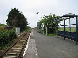
Quintrell Downs railway station serves the village of Quintrell Downs in Cornwall, England. It is 300 miles 16 chains measured from the zero point at ‹See TfM›London Paddington, on the Atlantic Coast Line. The station is managed by Great Western Railway with local services in each direction all calling here.
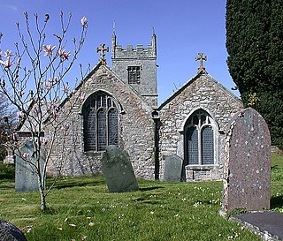
Colan is a village and civil parish in mid-Cornwall, England, United Kingdom. It is situated approximately three miles (5 km) east of Newquay. The electoral ward is called Colan and Mawgan. The population of this ward at the 2011 census was 4,256 The hamlets of Bosoughan, Chapel, Gwills, Kestle Mill, Lane, Mountjoy, Quintrell Downs, Trebarber and Trencreek are in the parish. The Fir Hill, and Firhill Woods near Nanswhyden, contains the ruins of Fir Hill Manor. Colan Church dates back to the thirteenth century.
St Dennis Junction was in St Dennis, Cornwall.
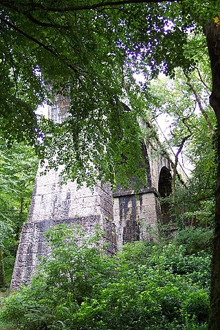
The Treffry Viaduct is a historic dual-purpose railway viaduct and aqueduct located close to the village of Luxulyan, Cornwall in the United Kingdom. The viaduct crosses the Luxulyan Valley and is part of the Treffry Tramways. It forms an integral part of the Cornwall and West Devon Mining Landscape, a World Heritage Site. It is scheduled under the Ancient Monuments and Archaeological Areas Act 1979 and due to its poor condition is on Historic England's, Heritage at Risk Register.

Withiel is a civil parish and village in mid Cornwall, England, United Kingdom. The parish of Withiel is between the parishes of St Breock, Lanivet, Roche and St Wenn. The name Withiel comes from the Cornish word Gwydhyel, meaning "wooded place". The parish contains the hamlets of Withielgoose, Retire and Tregawne; the parish had a total population of about 300 in 1824.
The Truro and Newquay Railway was a Great Western Railway line in Cornwall, England, designed to keep the rival London and South Western Railway (LSWR) out of the west of the county. The line was completed in 1905 and closed in 1963.

Kestle and Kestle Mill are hamlets in Cornwall, England. They are situated south of Quintrell Downs; Kestle Mill is on the A3058 main road. It is mostly in the civil parish of St. Newlyn East

Mountjoy is a hamlet in the civil parish of Colan in Cornwall, England. It is on the A392 road, east of Quintrell Downs.

Penhallow is a hamlet near Perranzabuloe in Cornwall, England. Penhallow is on the A3075 main road one km south of Perranzabuloe village.

Tregonetha is a village in Cornwall, England, UK. It is located in the civil parish of St Wenn, 7 miles (11 km) west of the town of Bodmin.

Trenance is a hamlet adjoining Mawgan Porth in Cornwall, England, United Kingdom. Trenance Point is a headland nearby.

Treninnick is a southeastern suburb of Newquay, Cornwall, England, United Kingdom, near Trencreek. It is in the civil parish of Newquay.

Newlyn Downs is a Site of Special Scientific Interest (SSSI) in north Cornwall, England, UK, noted for its biological characteristics.

The Mid Cornwall Metro (MCM) is a £56.8 million rail redevelopment project in Cornwall, United Kingdom. The project is designed to enhance coast-to-coast connectivity between the stations of Falmouth Docks and Newquay. Of the £56.8m, £50m is from the UK's Levelling Up Fund.
