Ralph Fitzhubert (1045 - 1086) was a Norman who after the 1066 Norman conquest was awarded extensive lands in England. [1] [2] [3]
Contents

Ralph Fitzhubert (1045 - 1086) was a Norman who after the 1066 Norman conquest was awarded extensive lands in England. [1] [2] [3]
In the Domesday Book of 1086 AD, FitzHubert is listed amongst the Derbyshire Domesday Book tenants-in-chief as owning lands in: Ashover, Ballidon, Bamford, Barlborough, Barrow-upon-Trent, Beighton, Boulton, Clifton, Clowne, Crich, Duckmanton and Long Duckmanton, Eckington, Egstow, Harthill, Hathersage, Ingleby, Kirk Langley, Lea, Middle, Nether and West Handley, Mosborough, Nether and Upper Hurst, Newton, Offerton, Ogston, Palterton, Pentrich, Ripley, Scarcliffe, Shuckstone, Stoney Middleton, Stretton, Tansley, Tunstall, Ufton, Werredune, Wessington, Whitwell, Willington, and Wirksworth
Ralph was the son of Hubert de Corcun (Derei). [4]

Hollingworth is a village in the Metropolitan Borough of Tameside, in Greater Manchester, England. It is about 11 miles (19 km) east of Manchester on the Derbyshire border near Glossop. Historically part of Cheshire, it gave its name to a family who owned much of the surrounding area from before the time of the Norman conquest.
Richard fitz Gilbert, 1st feudal baron of Clare in Suffolk, was a Norman lord who participated in the Norman conquest of England in 1066, and was styled "de Bienfaite", "de Clare", and of "Tonbridge" from his holdings.

Abbots Bickington is a village and civil parish in the English county of Devon, located 7.7 mi (12.4 km) north-northeast of Holsworthy and near the River Torridge.

Modbury is a large village, ecclesiastical parish, civil parish and former manor situated in the South Hams district of the county of Devon in England. Today due to its large size it is generally referred to as a "town" although the parish council has not elected to give itself the status of a town as it could do under s.245(6) of the Local Government Act 1972, so it does not have a town council and cannot have a town mayor. It is also known informally as a "market town", as from at least 1199 the lord of the manor has held the right to hold a regular market. The village is situated on the A379 road, which links it to Plymouth and Kingsbridge. The current parish population is approximately 1,500.
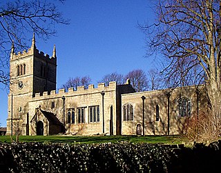
Scarcliffe is a village and civil parish in the Bolsover district of Derbyshire, England. It is sometimes called Scarcliffe with Palterton. The population of the parish at the 2001 UK Census was 5,211, increasing to 5,288 at the 2011 Census.
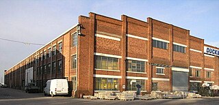
Duckmanton is a village within the civil parish of Sutton cum Duckmanton, in North East Derbyshire, between Bolsover and Chesterfield. Duckmanton is a long scattered village, running north and south, usually designated Long, Middle and Far Duckmanton, of which Middle Duckmanton is 4 miles (6.4 km) east from Chesterfield and 2.5 miles (4.0 km) west from Bolsover.
The Sheriff of Nottinghamshire, Derbyshire and the Royal Forests is a position established by the Normans in England.
Peter de Valognes (1045–1110) was a Norman noble who became a great landowner in England following the Norman Conquest.
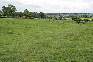
Hungry Bentley is a deserted medieval village and civil parish in the Derbyshire Dales district of Derbyshire, England, between Uttoxeter and Derby. The site is a scheduled monument and has been called the best "depopulated settlement" in Derbyshire. The name Bentley is said to mean a clearing with bent grass. The more unusual appellation of "Hungry" is said to refer to the poor quality of the land and the local inhabitants' poor food.

Bradbourne Priory was a priory in Bradbourne, Derbyshire, England.

The extent of the medieval district of Craven, in the north of England is a matter of debate. The name Craven is either pre-Celtic Britain, Britonnic or Romano-British in origin. However, its usage continued following the ascendancy of the Anglo-Saxons and the Normans – as was demonstrated by its many appearances in the Domesday Book of 1086. Places described as being In Craven in the Domesday Book fell later within the modern county of North Yorkshire, as well as neighbouring areas of West Yorkshire, Lancashire and Cumbria. Usage of Craven in the Domesday Book is, therefore, circumstantial evidence of an extinct, British or Anglo-Saxon kingdom or subnational entity.
William Paynel was an Anglo-Norman nobleman and baron. Son of a Domesday landholder, William inherited his father's lands in Yorkshire, Lincolnshire, and Normandy after the death of an older brother during their father's lifetime. After the death of King Henry I of England, Paynel supported Henry's daughter Matilda in her attempts to take the throne from her cousin Stephen, who had seized it. Matilda entrusted Nottingham Castle to Paynel's custody, although he lost it within two years when it was captured by a supporter of Stephen's. Paynel also founded two religious houses - one in England and one in Normandy. After Paynel's death around 1146, his lands were split between two sons.
Brictric was a powerful Saxon thegn whose many English landholdings, mostly in the West Country, are recorded in the Domesday Book of 1086.
Robert de Todeni, also known as Robert of Belvoir was an Anglo-Norman nobleman who held lands in England after the Norman Conquest.
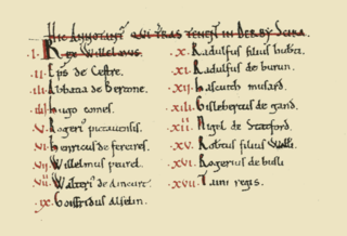
The Domesday Book of 1086 AD lists King William the Conqueror's tenants-in-chief in Derbyscire (Derbyshire), following the Norman Conquest of England:

The Domesday Book of 1086 AD lists King William the Conqueror's tenants-in-chief in Snotinghscire (Nottinghamshire), following the Norman Conquest of England:

The Domesday Book of 1086 AD identifies King William the Conqueror's tenants-in-chief in Cestrescire (Cheshire), following the Norman Conquest of England. At the time, the County of Cheshire included South Lancashire and most of modern Flintshire and Wrexham counties in north Wales.
The Domesday Book of 1086 AD identifies King William the Conqueror's tenants-in-chief for historic Lancashire within Cestrescire (Cheshire) and Eurvicscire (Yorkshire). At the time of the Norman Conquest of England, the County of Cheshire included Inter Ripam et Mersam which became South Lancashire, while the West Riding of the County of Yorkshire included what became North Lancashire.
The Hundreds of Derbyshire were the geographic divisions of the historic county of Derbyshire for administrative, military and judicial purposes. They were established in Derbyshire some time before the Norman conquest. In the Domesday Survey of 1086 AD the hundreds were called wapentakes. By 1273 the county was divided into 8 hundreds with some later combined, becoming 6 hundreds over the following centuries. The Local Government Act 1894 replaced hundreds with districts. Derbyshire is now divided into 8 administrative boroughs within the Derbyshire County Council area.