Dethick, Lea and Holloway

Last updated

Dethick, Lea, Holloway
Population1,027 (2011)
Civil parish
  • Dethick, Lea and Holloway
District
Shire county
Region
Country England
Sovereign state United Kingdom
Post town MATLOCK
Postcode district DE4
Dialling code 01629
Police Derbyshire
Fire Derbyshire
Ambulance East Midlands
UK Parliament
List of places
UK
England
Derbyshire
The Doctors Surgery and Florence Nightingale Memorial Hall in Holloway HollowayDerb.JPG
The Doctors Surgery and Florence Nightingale Memorial Hall in Holloway

Dethick, Lea and Holloway is a civil parish (and, since 1899, an ecclesiastical parish), in the Amber Valley borough of the English county of Derbyshire. The population of the civil parish taken at the 2011 census was 1,027. [1]

Contents

It is located in central Derbyshire, south east of Matlock, and, as its name suggests, contains the three main settlements Dethick, Lea and Holloway, as well as the younger village of Lea Bridge. [2]

The area's most notable family is the Nightingales, who were substantial landowners in the area and spent the summers there. Florence Nightingale stayed at Lea Hurst, and, during the 1880s, nursed her mother and rendered charitable work in the communities of Lea, Holloway and nearby Whatstandwell.

Holloway

The largest of the settlements that compose this civil parish is Holloway, at grid reference SK326562. Holloway has a village shop serving the parish, called 'Mayfield Stores'. Additionally, it is home to a doctor's surgery, a Methodist chapel, the Yew Tree public house (closed in 2008), a village butcher and a small art gallery. The southeastern area of the village is known as 'Leashaw', and the collection of houses scattered among the hills to the east is known as 'Upper Holloway'.

Leashaw is the location of Lea Hurst, famous for being built by the Nightingale family as their summer home.

A cotton mill was built in 1784 at Holloway by Peter Nightingale (a great uncle of Florence). He was sued by Richard Arkwright for infringement of patents. Although Arkwright won the case, it attracted the attention of the Lancashire pirate spinners, who in the end succeeded in getting the patents revoked. The mills were later sold to Thomas Smedley, whose son founded Smedley's Hydro in Matlock. The mill was converted to spinning worsted.

Leawood Hall off Mill Lane is a Grade II* listed Arts and Crafts house.

Lea

Lea Main Road; the Jug & Glass pub is on the right LeaDerb.JPG
Lea Main Road; the Jug & Glass pub is on the right

Lea lies north of Holloway at grid reference SK330575 and is, by population, the second biggest settlement in the parish. Unlike Dethick and Holloway, Lea is mentioned briefly in the Domesday Book when it was spelt Lede [3] and was owned by Ralph fitzHurbert. [4] Lea is the location of a council owned youth activity centre called Lea Green, the house was built as a home by Joseph Wass Esq. a wealthy local lead smelter and miner, lately inhabited by the Marsden Smedley family. Lea also has a public house called the Jug & Glass. There is also a small park, with play equipment for the youth of the parish.

Lea Bridge

A view of Lea Bridge LeabridgeDerb.JPG
A view of Lea Bridge

Geographically lowest of the settlements, Lea Bridge lies in the valley to the west of Holloway and to the southwest of Lea at grid reference SK318563 . This settlement grew around the need for workers houses for the nearby mills. Lea Bridge was considered an ideal location for the mills due to the power source in the form of Lea Brook which runs through the valley and into the river Derwent. The only one still operating is Smedleys, which celebrated its 230th anniversary in 2014. [5] Lea Bridge has a small football pitch and a large pond, known by the locals as the "mill pitch" and the "mill pond" respectively.

Dethick

Dethick and surrounding fields DethickDerb.JPG
Dethick and surrounding fields

Smallest of the settlements, but perhaps with the most interesting history, is Dethick. Dethick shares its name with the Dethick family, whose roots there can be traced with certainty to 1228, but who may well have been established there earlier. Historically the most notable family to be associated with Dethick are the Babingtons of Dethick Manor; Anthony Babington was executed for his leading role in a plot to rescue Mary, Queen of Scots, from imprisonment by her cousin Queen Elizabeth I of England. It will be found at grid reference SK327580 .

Accessibility

Although extremely rural, the parish has remained a popular place to live thanks to its relatively strong accessibility for such a small place. The towns of Alfreton, Belper, Matlock and Ripley are all just 15 minutes away. Derby, Chesterfield and Junction 28 of the M1 are also nearby, with journey times of around 25 minutes.

Facilities

The parish has one pub, a grocery, a butcher, a village hall, a church, a chapel, a Primary school and public toilets. The parish is able to receive ADSL Broadband, and since the digital switchover of the Bolehill transmitter in 2011, Freeview television. There is a once-hourly bus route (the 140/141/142) that stops in Lea Bridge, Holloway and Leashaw, connecting the Parish with Matlock, Belper, Ripley and Alfreton.

Tourist attractions

The parish includes two main tourist attractions.

Lea Gardens (also known as Lea Rhododendron Gardens for its extensive collection of this plant) is an open-air landscaped garden, open to the public during the summer months. At its entrance is a small café with indoor and outdoor seating, and a plant shop selling a wide variety of species (only open in summer).

John Smedley's Mill Lea Bridge - John Smedley Mill - Factory Shop.jpg
John Smedley's Mill

John Smedley's historic clothing mill retains a factory-outlet shop, selling the clothing that it makes at discount prices.

The Coach House at Lea was formerly a collection of farm buildings, converted to house an ice cream parlour, gift shop, restaurant, tea rooms and a limited amount of guest accommodation. The Coach House was famous for its home-made Jersey ice cream, the Shaw family having made the ice cream in a large range of flavours, but with changes of ownership, it is now a private home.

The parish is also very close to, but not linked with:

See also

Dethick, from 2.5 miles, wide.jpg
Dethick, from 2.5 miles

Related Research Articles

<span class="mw-page-title-main">Derwent Valley Mills</span> World Heritage site in Derbyshire, England

Derwent Valley Mills is a World Heritage Site along the River Derwent in Derbyshire, England, designated in December 2001. It is administered by the Derwent Valley Mills Partnership. The modern factory, or 'mill', system was born here in the 18th century to accommodate the new technology for spinning cotton developed by Richard Arkwright. With advancements in technology, it became possible to produce cotton continuously. The system was adopted throughout the valley, and later spread so that by 1788 there were over 200 Arkwright-type mills in Britain. Arkwright's inventions and system of organising labour was exported to Europe and the United States.

<span class="mw-page-title-main">River Derwent, Derbyshire</span> River in Derbyshire, England

The Derwent is a river in Derbyshire, England. It is 50 miles (80 km) long and is a tributary of the River Trent, which it joins south of Derby. Throughout its course, the river mostly flows through the Peak District and its foothills.

<span class="mw-page-title-main">Amber Valley</span> Non-metropolitan district and borough in England

Amber Valley is a local government district with borough status in the east of Derbyshire, England, taking its name from the River Amber. Its council is based in Ripley. The district covers a semi-rural area lying to the north of the city of Derby. The district contains four main towns whose economy was based on coal mining and remains to some extent influenced by engineering, distribution and manufacturing, holding for instance the headquarters and production site of Thorntons confectionery.

<span class="mw-page-title-main">Matlock, Derbyshire</span> County town of Derbyshire

Matlock is the county town of Derbyshire, England. It is in the south-eastern part of the Peak District, with the National Park directly to the west. The spa resort of Matlock Bath is immediately south of the town as well as Cromford lying further south still. The civil parish of Matlock Town had a population in the 2021 UK census of 10,000.

<span class="mw-page-title-main">Wirksworth</span> Market town in Derbyshire, England

Wirksworth is a market town in the Derbyshire Dales district of Derbyshire, England. Its population of 4,904 in the 2021 census was estimated at 5,220 in 2023. Wirksworth contains the source of the River Ecclesbourne. The town was granted a market charter by Edward I in 1306 and still holds a market on Tuesdays in the Memorial Gardens. The parish church of St Mary's is thought to date from 653. The town developed as a centre for lead mining and stone quarrying. Many lead mines were owned by the Gell family of nearby Hopton Hall.

<span class="mw-page-title-main">Whatstandwell</span> Human settlement in England

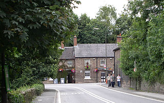
Whatstandwell is a village on the River Derwent in the Amber Valley district of Derbyshire, England. It is about five miles south of Matlock and about four miles north of Belper. Whatstandwell railway station is on the Derby–Matlock Derwent Valley Line, and the A6 trunk road crosses the River Derwent in the village. Most of the population is included in the civil parish of Crich but the village may be said to extend across the Derwent into the parish of Alderwasley.

<span class="mw-page-title-main">Cromford</span> Village in Derbyshire, England

Cromford is a village and civil parish in Derbyshire, England, in the valley of the River Derwent between Wirksworth and Matlock. It is 17 miles (27 km) north of Derby, 2 miles (3.2 km) south of Matlock and 1 mile (1.6 km) south of Matlock Bath. It is first mentioned in the 11th-century Domesday Book as Crumforde, a berewick of Wirksworth, and this remained the case throughout the Middle Ages. The population at the 2011 Census was 1,433. It is principally known for its historical connection with Richard Arkwright and the nearby Cromford Mill, which he built outside the village in 1771. Cromford is in the Derwent Valley Mills World Heritage Site.

<span class="mw-page-title-main">Cromford Canal</span>

The Cromford Canal ran 14.5 miles from Cromford to the Erewash Canal in Derbyshire, England with a branch to Pinxton. Built by William Jessop with the assistance of Benjamin Outram, its alignment included four tunnels and 14 locks.

<span class="mw-page-title-main">Ambergate</span> Human settlement in England

Ambergate is a village in Derbyshire, England, situated where the River Amber joins the River Derwent, and where the A610 road from Ripley and Nottingham joins the A6 that runs along the Derwent valley between Derby to the south and Matlock to the north. Sawmills and Ridgeway are neighbouring hamlets, and Alderwasley, Heage, Nether Heage and Crich are other significant neighbouring settlements. The village forms part of the Heage and Ambergate ward of Ripley Town Council with a population of 5,013 at the 2011 Census. Ambergate is within the Derwent Valley Mills UNESCO World Heritage site, and has historical connections with George Stephenson; Ambergate is notable for its railway heritage and telephone exchange. Ambergate has an active community life, particularly centred on the school, pubs, churches, sports clubs; and annual village carnival which is relatively large and consistent locally, with popular associated events in carnival week and throughout the year. The carnival is organised by a voluntary committee. Shining Cliff woods, Thacker's woods and Crich Chase border the village.

<span class="mw-page-title-main">Milford, Derbyshire</span> Village in Derbyshire, England

Milford is a village in Derbyshire, England, on the River Derwent, between Duffield and Belper on the A6 trunk road.

John Smedley Ltd is an English luxury clothing brand specialising in knitwear like polo shirts and sweaters for men and women. The company applies a “Made in England” tag to every garment made. John Smedley has remained a family business since 1784, and is now managed by the 8th generation of the Smedley family. Historically, four generations of men named John Smedley owned Lea Mills, near Matlock, Derbyshire. The most famous of these was John Smedley (1803–1874), who is considered the namesake of the brand. The John Smedley company sells clothing in over 30 countries; its largest export market is Japan. In the UK, John Smedley has concessions in branches of Flannels and Fenwick.

<span class="mw-page-title-main">Bullbridge</span> Human settlement in England

Bullbridge is a small village in Derbyshire. The Bull bridge accident, in which a railway bridge failed as a goods train was just passing over it, happened here in 1860.

<span class="mw-page-title-main">Derwent Valley Heritage Way</span> Long distance footpath in England

The Derwent Valley Heritage Way (DVHW) is a 55 miles (89 km) waymarked footpath along the Derwent Valley through the Peak District. The walk starts from Ladybower Reservoir in the Peak District National Park via Chatsworth, the scenery around the Derbyshire Dales, and through the Derwent Valley Mills World Heritage Site. It follows the Riverside Path through Derby and continues onwards to the historic inland port of Shardlow. Journey's end is at Derwent Mouth where the River Derwent flows into the River Trent.

There are a number of listed buildings in Derbyshire. The term "listed building", in the United Kingdom, refers to a building or structure designated as being of special architectural, historical, or cultural significance. Details of all the listed buildings are contained in the National Heritage List for England. They are categorised in three grades: Grade I consists of buildings of outstanding architectural or historical interest, Grade II* includes significant buildings of more than local interest and Grade II consists of buildings of special architectural or historical interest. Buildings in England are listed by the Secretary of State for Culture, Media and Sport on recommendations provided by English Heritage, which also determines the grading.

Dethick, Lea and Holloway is a civil parish in the Amber Valley district of Derbyshire, England. The parish contains 36 listed buildings that are recorded in the National Heritage List for England. Of these, five are listed at Grade II*, the middle of the three grades, and the others are at Grade II, the lowest grade. The parish contains the villages of Dethick, Lea, and Holloway, and the surrounding area. Most of the listed buildings are country houses, smaller houses, cottages, and associated structures. The other listed buildings include churches and chapels, a public house, farmhouses and farm buildings, and a bridge.

References

  1. "Civil Parish population 2011". Neighbourhood Statistics. Office for National Statistics. Archived from the original on 18 January 2017. Retrieved 17 March 2016.
  2. From Kelly's Directory of the Counties of Derby, Notts, Leicester and Rutland (London; May, 1891), pp. 183-184: "DETHICK, LEA and HOLLOWAY form a chapelry, 11 miles south-east from Chesterfield, 2½ south-east-by-east from Matlock Town and 2½ north-by-east from Cromford, which is a station on the Midland railway, in the Western division of the county, Wirksworth hundred and county court district, Matlock and Wirksworth petty sessional division, Belper union, rural deanery of Alfreton, archdeaconry of Derby and diocese of Southwell. The church of St. John the Baptist is a small edifice of stone, dating from 1220, and consists of chancel, nave and a lofty western tower, dated 1535, containing one small bell: there are three memorial windows, and 60 sittings. The living is a vicarage, gross yearly value £110, including 53 acres of glebe, in the patronage of the Rev. Brabazon Hallowes H.A. of Glapwell, near Mansfield, and held since 1860 by the Rev. Charles Holcombe Leacroft M.A. of Trinity College, Cambridge, who is also vicar of and resides at Brackenfield. Gisborne's charity of £6 10S. yearly is for clothing. The Rev. Brabazon Hallowes M,A. is lord of the manor of Dethick and principal landowner. The soil is sandy; subsoil, gritstone. The chief crops are wheat, barley, oats and about one-half the land is in pasture. The acreage is 1,826; rateable value, £4,748; the population in 1881 was 1,036."
  3. Domesday Book: A Complete Translation. London: Penguin, 2003. ISBN   0-14-143994-7 p.752
  4. Ralph fitzHubert held a considerable number of manors including several in Derbyshire given to him by the King. These included obviously Lea but also included lands in Eckington, Barlborough, Whitwell, Stretton, Ashover, Newton, Crich, Ingleby, Stoney Middleton, Wirksworth and Hathersage
  5. "The Queen is to visit Matlock". Matlock Mercury.
  6. Alistair D. McGown & Mark J. Docherty, The Hill and Beyond: Children's Television Drama - An Encyclopedia, British Film Institute, 2003, p. 113