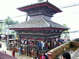
Pokharathok is a small town in Arghakhanchi District in the Lumbini Zone of southern Nepal. At the time of the 1991 Nepal census it had a population of 3,373 and had 622 houses in the town.
Daga Tumdada is a village development committee in Baglung District in the Dhaulagiri Zone of central Nepal. At the time of the 1991 Nepal census it had a population of 4,874 and had 897 houses in the town.
Hile is a village development committee in Baglung District in the Dhaulagiri Zone of central Nepal. At the time of the 1991 Nepal census it had a population of 2,891 and had 530 houses in the village. The town was founded in 1978.
Kalleri is a village development committee in Dhading District in the Bagmati Zone of central Nepal. At the time of the 1991 Nepal census it had a population of 7848 and had 1433 houses in it.
Chyangli is a village development committee in Gorkha District in the Gandaki Zone of northern-central Nepal. At the time of the 1991 Nepal census it had a population of 5,612 and had 1066 houses in the town.
Deurali is a Village Development Committee in Gorkha District in the Gandaki Zone of northern-central Nepal. At the time of the 1991 Nepal census it had a population of 4,800 and had 984 houses in the town.

Manakamana is a village development committee in Gorkha District in the Gandaki Zone of northern-central Nepal. At the time of the 1991 Nepal census it had a population of 5,083 and had 889 houses in the town.
Ranishwara is a village development committee in Gorkha District in the Gandaki Zone of northern-central Nepal. At the time of the 1991 Nepal census it had a population of 2,993 and had 580 houses in the town.
Tandrang is a Village Development Committee in Gorkha District in the Gandaki Zone of northern-central Nepal. At the time of the 1991 Nepal census it had a population of 4,368 and had 838 houses in the town.
Bolde Phediche is a village development committee in Kabhrepalanchok District in the Bagmati Zone of central Nepal. At the time of the 1991 Nepal census it had a population of 2324 and had 418 houses in it.
Mijuredanda is a town and Village Development Committee in Kaski District in the Gandaki Zone of northern-central Nepal. At the time of the 1991 Nepal census it had a population of 4,394 persons living in 907 individual households.
Deurali, Tanahu is a village development committee in Tanahu District in the Gandaki Zone of central Nepal. At the time of the 1991 Nepal census it had a population of 2910 people living in 44 individual households.
Ranipokhari, Nepal is a village development committee in Tanahu District in the Gandaki Zone of central Nepal. At the time of the 1991 Nepal census it had a population of 2984 people living in 510 individual households.
Dhyaurali is a village development committee in Ramechhap District in the Janakpur Zone of north-eastern Nepal. At the time of the 1991 Nepal census it had a population of 3111 people living in 616 individual households.
Basantpur is a village development committee in Parsa District in the Narayani Zone of southern Nepal. At the time of the 2011 Nepal census it had a population of 7,933 people living in 1,157 individual households. There were 4,094 males and 3,839 females at the time of census.
Deurali is a village development committee in Nawalparasi District in the Lumbini Zone of southern Nepal. At the time of the 1991 Nepal census it had a population of 10,537 people living in 1627 individual households.
Humsekot is a village development committee in Nawalparasi District in the Lumbini Zone of southern Nepal. At the time of the 1991 Nepal census it had a population of 3015 people living in 472 individual households.
Manjhariya is a village development committee in Nawalparasi District in the Lumbini Zone of southern Nepal. At the time of the 1991 Nepal census, Manjhariya had a population of 2,977 people living in 427 individual households.
Parsauni is a village development committee in Nawalparasi District in the Lumbini Zone of southern Nepal. At the time of the 2001 Nepal census it had a population of 6000 people living in 850 individual households.
Bakamalang is a village development committee (VDC) in Palpa District in the Lumbini Zone of southern Nepal. At the time of the 1991 Nepal census it had a population of 2861 people living in 472 individual households.It is surrounded by Rakuwa in the North-East, Ruching in the South-East, Sahalkot in the South-West and Gadakot in the North-West. The North-East border of Bakamalang VDC resembles the Gandaki River.


