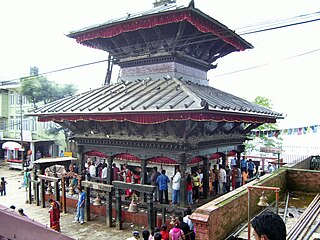
Dhuwakot is a village development committee in Gorkha District in the Gandaki Zone of central Nepal. In 1991 Nepal census, it had a population of 4270 with 781 houses in it. Such as Mirkot, Gaikhur, Palumtar are the neighbouring VDCs of Dhuwakot VDC.There are mainly Naharki's(नहर्की) caste is more in an average than others.
Kalleri is a village development committee in Dhading District in the Bagmati Zone of central Nepal. At the time of the 1991 Nepal census it had a population of 7848 and had 1433 houses in it.

Kumpur is a village development committee in Dhading District in Province No. 3 in central Nepal. At the time of the 1991 Nepal census it had a population of 7916 and had 1405 houses in it.
Chyangli is a village development committee in Gorkha District in the Gandaki Zone of northern-central Nepal. At the time of the 1991 Nepal census it had a population of 5,612 and had 1066 houses in the town.
Deurali is a Village Development Committee in Gorkha District in the Gandaki Zone of northern-central Nepal. At the time of the 1991 Nepal census it had a population of 4,800 and had 984 houses in the town.
Kerabari is a Village Development Committee in Gorkha District in the Gandaki Zone of northern-central Nepal. At the time of the 1991 Nepal census it had a population of 2,692 and had 535 houses in the village

Manakamana is a village development committee in Gorkha District in the Gandaki Zone of northern-central Nepal. At the time of the 1991 Nepal census it had a population of 5,083 and had 889 houses in the town.

Ranishwara is a village development committee in Gorkha District in Gandaki Pradesh of northern-central Nepal. At the time of the 1991 Nepal census it had a population of 2,993 and had 580 houses in the town.
Uiya is a village development committee in Gorkha District in the Gandaki Zone of northern-central Nepal. At the time of the 1991 Nepal census it had a population of 1,728 and had 382 houses.
Bolde Phediche is a village development committee in Kabhrepalanchok District in Bagmati Pradesh of central Nepal. At the time of the 1991 Nepal census it had a population of 2324 and had 418 houses in it.
Chhinamukh is a village development committee in Bhojpur District in the Kosi Zone of eastern Nepal. At the time of the 1991 Nepal census it had a population of 3375 persons living in 639 individual households.
Mijuredanda is a town and Village Development Committee in Kaski District in Gandaki Pradesh of northern-central Nepal. At the time of the 1991 Nepal census it had a population of 4,394 persons living in 907 individual households.
Deurali, Tanahu is a village development committee in Tanahu District in the Gandaki Zone of central Nepal. At the time of the 1991 Nepal census it had a population of 2910 people living in 44 individual households.
Ranipokhari, Nepal is a village development committee in Tanahu District in the Gandaki Zone of central Nepal. At the time of the 1991 Nepal census it had a population of 2984 people living in 510 individual households.
Dhyaurali is a village development committee in Ramechhap District in the Janakpur Zone of north-eastern Nepal. At the time of the 1991 Nepal census it had a population of 3111 people living in 616 individual households.

Kumarwarti is a village development committee in Nawalparasi District in the Lumbini Zone of southern Nepal. At the time of the 1991 Nepal census it had a population of 4155 people living in 698 individual households. However data derived more recently for marriage and education details has suggested in 2001 the population had grown to over 5000.
Manjhariya is a village development committee in Nawalparasi District in the Lumbini Zone of southern Nepal. At the time of the 1991 Nepal census, Manjhariya had a population of 2,977 people living in 427 individual households.
Parsauni is a village development committee in Nawalparasi District in the Lumbini Zone of southern Nepal. At the time of the 2001 Nepal census it had a population of 6000 people living in 850 individual households.
Ratnapur is a village development committee in Nawalparasi District in the Lumbini Zone of southern Nepal. At the time of the 1991 Nepal census it had a population of 2936.
Bakamalang is a village development committee in Palpa District in the Lumbini Zone of southern Nepal. At the time of the 1991 Nepal census it had a population of 2861 people living in 472 individual households. It is surrounded by Rakuwa in the northeast, Ruching in the southeast, Sahalkot in the southwest and Gadakot in the northwest. The northeast border of Bakamalang village development committee resembles the Gandaki River.


