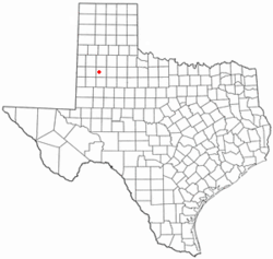
Reese Center, Texas | |
---|---|
Former CDP | |
Coordinates: 33°35′36″N102°1′48″W / 33.59333°N 102.03000°W | |
Country | United States |
State | Texas |
County | Lubbock |
Area | |
• Total | 6.5 sq mi (16.9 km2) |
• Land | 6.5 sq mi (16.9 km2) |
• Water | 0.0 sq mi (0.0 km2) |
Population (2000) | |
• Total | 42 |
• Density | 6.4/sq mi (2.5/km2) |
Time zone | UTC-6 (Central (CST)) |
• Summer (DST) | UTC-5 (CDT) |
FIPS code | 48-61406 [1] |
Reese Center is an unincorporated community and former census-designated place (CDP) in Lubbock County, Texas, United States. The population was 42 at the 2000 census. Its population was not recorded separately for the 2010 census. It is part of the Lubbock Metropolitan Statistical Area.
Reese Center is located at 33°35′36″N102°1′48″W / 33.59333°N 102.03000°W (33.593363, -102.030076). [2] The community is bordered by the former Reese Air Force Base to the west and by the city of Lubbock to the south and east.
According to the United States Census Bureau, the CDP had a total area of 6.5 square miles (17 km2), all land.
Census | Pop. | Note | %± |
---|---|---|---|
2000 | 42 | — | |
U.S. Decennial Census [3] 1850–1900 [4] 1910 [5] 1920 [6] 1930 [7] 1940 [8] 1950 [9] 1960 [10] 1970 [11] 1980 [12] 1990 [13] 2000 [14] 2010 [15] |
Reese Center first appeared in the 2000 U.S. Census and includes parts of the Reese Air Force Base [14] which was closed in 1997. [16] It was deleted prior to the 2010 U.S. Census. [15]
Race / Ethnicity (NH = Non-Hispanic) | Pop 2000 [17] | % 2000 |
---|---|---|
White alone (NH) | 35 | 83.33% |
Black or African American alone (NH) | 0 | 0.00% |
Native American or Alaska Native alone (NH) | 1 | 2.38% |
Asian alone (NH) | 0 | 0.00% |
Pacific Islander alone (NH) | 0 | 0.00% |
Other race alone (NH) | 0 | 0.00% |
Mixed race or Multiracial (NH) | 0 | 0.00% |
Hispanic or Latino (any race) | 6 | 14.29% |
Total | 42 | 100.00% |
As of the census [1] of 2000, there were 42 people, 13 households, and 10 families residing in the CDP. The population density was 6.4 people per square mile (2.5/km2). There were 14 housing units at an average density of 2.1/sq mi (0.8/km2). The racial makeup of the CDP was 95.24% White, 2.38% Native American, 2.38% from other races. Hispanic or Latino of any race were 14.29% of the population.
There were 13 households, out of which 69.2% had children under the age of 18 living with them, 84.6% were married couples living together, and 15.4% were non-families. 15.4% of all households were made up of individuals, and 7.7% had someone living alone who was 65 years of age or older. The average household size was 3.23 and the average family size was 3.55.
In the CDP the population was spread out, with 38.1% under the age of 18, 40.5% from 25 to 44, 11.9% from 45 to 64, and 9.5% who were 65 years of age or older. The median age was 34 years. For every 100 females, there were 133.3 males. For every 100 females age 18 and over, there were 136.4 males.
The median income for a household in the CDP was $23,750, and the median income for a family was $12,292. Males had a median income of $11,250 versus $11,250 for females. The per capita income for the CDP was $7,393. None of the population or families were below the poverty line.
Tynan is a census-designated place (CDP) in Bee County, Texas, United States. The population was 254 at the 2020 census.
Lake Brownwood is a census-designated place (CDP) located in Brown County in central Texas, United States. The population was 1,532 at the 2010 census.
Arroyo Colorado Estates is a census-designated place (CDP) in Cameron County, in the U.S. state of Texas. The population was 997 at the 2010 census. It is part of the Brownsville–Harlingen Metropolitan Statistical Area.
Bixby is a census-designated place (CDP) in Cameron County, Texas, United States. The population was 352 at the 2020 census. It is part of the Brownsville–Harlingen Metropolitan Statistical Area.
Cameron Park is a census-designated place (CDP) in Cameron County, Texas, United States. The population was 6,099 at the 2020 census. It is part of the Brownsville–Harlingen Metropolitan Statistical Area.
Green Valley Farms is a census-designated place (CDP) in Cameron County, Texas, United States. The population was 655 at the 2020 census, down from 1,272 at the 2010 census. It is part of the Brownsville–Harlingen Metropolitan Statistical Area.
La Paloma is a census-designated place (CDP) in Cameron County, Texas, United States. The population was 2,903 at the 2010 census, up from 354 at the 2000 census, when it was drawn to cover a much smaller area. By the 2020 census, the population further increased to 3,218. It is part of the Brownsville–Harlingen Metropolitan Statistical Area.
Laureles is a census-designated place (CDP) in Cameron County, Texas, United States. The population was 4,111 at the 2020 census. It is part of the Brownsville–Harlingen Metropolitan Statistical Area. Laureles is an area between Los Fresnos and San Benito.
Lozano is a census-designated place (CDP) in Cameron County, Texas, United States. The population was 404 at the 2010 census, up from 324 at the 2000 census. By the 2020 census, the population went drastically down to 174. It is part of the Brownsville–Harlingen Metropolitan Statistical Area.
West Odessa is an unincorporated area and census-designated place (CDP) in Ector County, Texas, United States, on the west side of the city of Odessa. The population was 22,707 at the 2010 census, up from 17,799 at the 2000 census. It is part of the Odessa metropolitan area.
Seth Ward is an unincorporated community and census-designated place (CDP) in Hale County, Texas, United States. The population was 2,025 at the 2010 census.
Relampago is a census-designated place (CDP) in Hidalgo County, Texas, United States. The population was 129 at the 2020 United States Census. It is part of the McAllen–Edinburg–Mission Metropolitan Statistical Area.
Las Lomitas is an unincorporated community and census-designated place (CDP) in Jim Hogg County, Texas, United States. The population was 235 at the 2020 census.
South Toledo Bend is a census-designated place (CDP) in Newton County, Texas, United States. The population was 434 at the 2020 census, down from 524 at the 2010 census.
West Alto Bonito is a census-designated place (CDP) in Starr County, Texas, United States. The population was 615 in 2020 census. Prior to the 2010 census, West Alto Bonito CDP was known as Alto Bonito CDP.
La Puerta is a census-designated place (CDP) in Starr County, Texas, United States. The population was 638 at the 2020 census, an increase from the figure of 632 tabulated in 2010 census.
Roma Creek is a former census-designated place (CDP) in Starr County, Texas, United States. The population was 350 at the 2010 census down from 610 at the 2000 census.
San Isidro is a census-designated place (CDP) in Starr County, Texas, United States. The population was 240 at the 2010 census. The town is named for St. Isidore the Laborer, the patron saint of farmers. A large Southwestern Barrel Cactus growing just east of town is said to be the largest in Texas.
Oilton is a census-designated place (CDP) in Webb County, Texas, United States. The population was 152 at the 2010 census. The community is within the boundary of Webb Consolidated Independent School District and is home to the Oilton Elementary School.
Ranchitos Las Lomas is a census-designated place (CDP) in Webb County, Texas, United States. The population was 167 at the 2020 census. Las Lomas means "the hills" in Spanish.