Rewley Road Swing Bridge

Last updated

Rewley Road Swing Bridge
Oxford - LNWR Swing Bridge - geograph.org.uk - 95063.jpg
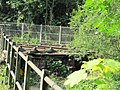
The old Rewley Road Swing Bridge with the newer Sheepwash Channel Railway Bridge behind over the Sheepwash Channel.
Coordinates 51°45′20″N1°16′15″W / 51.755599°N 1.270721°W / 51.755599; -1.270721
Carries Buckinghamshire Railway
Crosses Sheepwash Channel
Locale Oxford, England
Maintained by Oxford Preservation Trust
Characteristics
Design Swing bridge
Material Steel girder
No. of spans1
History
Designer Robert Stephenson
Opened1851
Closed1984
Location
Rewley Road Swing Bridge

Rewley Road Swing Bridge is a disused railway swing bridge over Sheepwash Channel in west Oxford, England. [1] [2] To the north are Cripley Meadow and Fiddler's Island and to the south are Osney Island and the Botley Road.

Contents

The bridge was designed by Robert Stephenson and built in 1850–1. [3] It was reconstructed in 1890 and 1906, latterly using steel girders. The bridge closed to passenger traffic in 1951 and to goods in 1984.

Overview

The swing bridge was for the former Buckinghamshire Railway line of London and North Western Railway that used to serve the Oxford Rewley Road railway station (later London, Midland and Scottish Railway, LMS), which was on the site of the Saïd Business School. [4] [5] It is close to Rewley Road Bridge to the east and Sheepwash Channel Railway Bridge to the west, which also cross Sheepwash Channel. [1]

Restoration project

The bridge is one of two swing bridges in England that are scheduled monuments. [3] In 2019, ownership passed from Network Rail to the Oxford Preservation Trust. [6]

Related Research Articles

<span class="mw-page-title-main">Grand Union Canal</span> Canal in England

The Grand Union Canal in England is part of the British canal system. It is the principal navigable waterway between London and the Midlands. Starting in London, one arm runs to Leicester and another ends in Birmingham, with the latter stretching for 137 miles (220 km) with 166 locks from London. The Birmingham line has a number of short branches to places including Slough, Aylesbury, Wendover, and Northampton. The Leicester line has two short arms of its own, to Market Harborough and Welford.

<span class="mw-page-title-main">River Thames</span> River in southern England

The River Thames, known alternatively in parts as the River Isis, is a river that flows through southern England including London. At 215 miles (346 km), it is the longest river entirely in England and the second-longest in the United Kingdom, after the River Severn.

<span class="mw-page-title-main">Oxford Canal</span> Canal in England

The Oxford Canal is a 78-mile (126 km) narrowboat canal in southern central England linking the City of Oxford with the Coventry Canal at Hawkesbury via Banbury and Rugby. Completed in 1790, it connects to the River Thames at Oxford, and links with the Grand Union Canal, which it is combined with for 5 miles (8 km) between to the villages of Braunston and Napton-on-the-Hill.

<span class="mw-page-title-main">Swing bridge</span> Bridge which pivots around the mid-point

A swing bridge is a movable bridge that has as its primary structural support a vertical locating pin and support ring, usually at or near to its center of gravity, about which the swing span can then pivot horizontally as shown in the animated illustration to the right. Small swing bridges as found over canals may be pivoted only at one end, opening as would a gate, but require substantial underground structure to support the pivot.

<span class="mw-page-title-main">River Cherwell</span> Tributary of the River Thames in central England

The River Cherwell is a tributary of the River Thames in central England. It rises near Hellidon, Northamptonshire and flows southwards for 40 miles (64 km) to meet the Thames at Oxford in Oxfordshire.

<span class="mw-page-title-main">Cotswold Line</span> Railway line between Oxford and Hereford

The Cotswold Line is an 86+12-mile (139.2 km) railway line between Oxford and Hereford in England.

<span class="mw-page-title-main">Oxford railway station</span> Railway station in Oxfordshire, England

Oxford railway station is a mainline railway station, one of two serving the city of Oxford, England. It is about 0.5 miles (800 m) west of the city centre, north-west of Frideswide Square and the eastern end of Botley Road. It is the busiest station in Oxfordshire, and the fourth busiest in South East England.

<span class="mw-page-title-main">Osney</span> Human settlement in England

Osney or Osney Island is a riverside community in the west of the city of Oxford, England. In modern times the name is applied to a community also known as Osney Town astride Botley Road, just west of the city's main railway station, on an island surrounded by the River Thames, Osney Ditch and another backwater connecting the Thames to Osney Ditch.

<span class="mw-page-title-main">Oxford Rewley Road railway station</span> Former railway station in England

Oxford Rewley Road railway station was a railway station serving the city of Oxford, England, located immediately to the north of what is now Frideswide Square on the site of the Saïd Business School, to the west of Rewley Road. It was the terminus of the Buckinghamshire Railway, which was worked, and later absorbed, by the London and North Western Railway (L&NWR). In 1923 it became part of the London, Midland and Scottish Railway (LMS), "Varsity Line" service from Cambridge via Bletchley and had features of significance in construction history.

<span class="mw-page-title-main">Osney Lock</span> Lock on the River Thames in Oxfordshire, England

Osney Lock is a lock on the River Thames in Oxford, England, where the village or island of Osney is next to the river.

<span class="mw-page-title-main">Fiddler's Island</span>

Fiddler's Island is an island in the River Thames at Oxford in England. It is situated south of Port Meadow on the reach above Osney Lock.

<span class="mw-page-title-main">Castle Mill Stream</span> Stream in Oxfordshire, England

Castle Mill Stream is a backwater of the River Thames in the west of Oxford, England. It is 5.5 km long.

<span class="mw-page-title-main">Duke's Cut</span>

Duke's Cut is a short waterway in Oxfordshire, England, which connects the Oxford Canal with the River Thames via the Wolvercote Mill Stream. It is named after George Spencer, 4th Duke of Marlborough, across whose land the waterway was cut. It is seen as a branch of the Oxford Canal.

<span class="mw-page-title-main">Aristotle Lane</span> Street in North Oxford, UK

Aristotle Lane is a road in north Oxford, England.

<span class="mw-page-title-main">Bulstake Stream</span> Stream in Oxfordshire, England

Bulstake Stream, also spelt Bullstake Stream, is a backwater of the River Thames at Oxford, England.

<span class="mw-page-title-main">Rewley Road</span>

Rewley Road is in the west of central Oxford, England. It is located in St Thomas's parish.

<span class="mw-page-title-main">Sheepwash Channel</span> Backwater in Oxford, England

Sheepwash Channel connects the River Thames to the west and the Castle Mill Stream next to the Oxford Canal to the east, in west Oxford, England. To the north are Cripley Meadow and Fiddler's Island. To the south are Osney Island and the Botley Road.

<span class="mw-page-title-main">Isis Lock</span>

Isis Lock is a lock connecting the Oxford Canal and the Castle Mill Stream, a backwater of the River Thames in Oxford, England.

<span class="mw-page-title-main">Sheepwash Channel Railway Bridge</span> Bridge in Oxford, England

Sheepwash Channel Railway Bridge is a railway bridge over Sheepwash Channel in west Oxford, England, just north of Oxford railway station. To the north are Cripley Meadow and Fiddler's Island. To the south are Osney Island and the Botley Road.

<span class="mw-page-title-main">Cripley Meadow</span> Human settlement in England

Cripley Meadow lies between the Castle Mill Stream, a backwater of the River Thames, and the Cotswold Line railway to the east, and Fiddler's Island, on the main branch of the Thames to the west, in Oxford, England. It is to the south of the better known Port Meadow, a large meadow of common land. To the south is Sheepwash Channel which connects the Oxford Canal with the River Thames.

References

  1. 1 2 "River Thames (Sheepwash Channel)". UK: CanalPlanAC. Retrieved 15 September 2012.
  2. "Rewley Road Swing Bridge". Dereliction in the Shires: Oxfordshire Urban Exploration. Retrieved 18 September 2012.
  3. 1 2 Woolley, Liz (2012). Oxford's Working Past. Huxley Scientific Press. p. 14. ISBN   978-0-9522671-7-1.
  4. "Sheepwash Channel — Oxford Canal / River Thames". UK: Movable Bridges in the British Isles. Retrieved 15 September 2012.
  5. "Rewley Road (LMS) Swing Bridge". Projects. UK: Oxford Preservation Trust . Retrieved 10 April 2017.
  6. Regional News Rail issue 882 3 July 2019 page 26