Sheepwash Channel Railway Bridge

Last updated

Sheepwash Channel Railway Bridge

Oxford - LNWR Swing Bridge - geograph.org.uk - 95063.jpg

The Sheepwash Channel Railway Bridge with the old Rewley Road Swing Bridge in the foreground, on the Sheepwash Channel.
Coordinates 51°45′20″N1°16′15″W / 51.755586°N 1.270946°W / 51.755586; -1.270946 Coordinates: 51°45′20″N1°16′15″W / 51.755586°N 1.270946°W / 51.755586; -1.270946
Carries Cherwell Valley Line
Crosses Sheepwash Channel
Locale Oxford, England
Maintained by Network Rail
Characteristics
Design Girder bridge
Material Steel
No. of spans 1

Sheepwash Channel Railway Bridge is a railway bridge over Sheepwash Channel in west Oxford, England, just north of Oxford railway station. [1] To the north are Cripley Meadow and Fiddler's Island. To the south are Osney Island and the Botley Road.

Sheepwash Channel

Sheepwash Channel connects the River Thames to the west and the Castle Mill Stream next to the Oxford Canal to the east, in west Oxford, England. To the north are Cripley Meadow and Fiddler's Island. To the south are Osney Island and the Botley Road.

Oxford City and non-metropolitan district in England

Oxford is a university city in south central England and the county town of Oxfordshire. With a population of approximately 155,000, it is the 52nd largest city in the United Kingdom, with one of the fastest growing populations in the UK, and it remains the most ethnically diverse area in Oxfordshire county. The city is 51 miles (82 km) from London, 61 miles (98 km) from Bristol, 59 miles (95 km) from Southampton, 57 miles (92 km) from Birmingham and 24 miles (39 km) from Reading.

England Country in north-west Europe, part of the United Kingdom

England is a country that is part of the United Kingdom. It shares land borders with Wales to the west and Scotland to the north-northwest. The Irish Sea lies west of England and the Celtic Sea lies to the southwest. England is separated from continental Europe by the North Sea to the east and the English Channel to the south. The country covers five-eighths of the island of Great Britain, which lies in the North Atlantic, and includes over 100 smaller islands, such as the Isles of Scilly and the Isle of Wight.

The bridge is close to Rewley Road Swing Bridge just to the east, [2] an older and now disused swing bridge for the former Buckinghamshire Railway line of London and North Western Railway that used to serve the Oxford Rewley Road railway station. [3] It is also close to Rewley Road Bridge to the east. [1] Sheepwash channel links the River Thames with the Oxford Canal via Castle Mill Stream and Isis Lock.

Rewley Road Swing Bridge

Rewley Road Swing Bridge is a disused railway swing bridge over Sheepwash Channel in west Oxford, England. To the north are Cripley Meadow and Fiddler's Island and to the south are Osney Island and the Botley Road.

Swing bridge movable bridge that has a vertical locating pin and support ring about which the turning span can pivot horizontally

A swing bridge is a movable bridge that has as its primary structural support a vertical locating pin and support ring, usually at or near to its center of gravity, about which the turning span can then pivot horizontally as shown in the animated illustration to the right. Small swing bridges as found over canals may be pivoted only at one end, opening as would a gate, but require substantial underground structure to support the pivot.

The Buckinghamshire Railway was a railway company in Buckinghamshire and Oxfordshire, England that constructed railway lines connecting Bletchley, Banbury and Oxford. Part of the route is still in use today as the Oxford to Bicester Line.

Oxford railway station

Oxford railway station is a mainline railway station serving the city of Oxford, England. It is about 0.5 miles (800 m) west of the city centre, north-west of Frideswide Square and the eastern end of Botley Road. It is on the line for trains between London Paddington and Hereford via Worcester Shrub Hill. It is a starting point for fast and local trains to London Paddington and London Marylebone, and for local trains to Reading, Worcester, and Banbury. It is also on the north/south Cross Country Route from Manchester Piccadilly and Newcastle via Birmingham New Street and Reading to Southampton Central and Bournemouth. The station is managed by Great Western Railway, and also served by CrossCountry and Chiltern Railways trains. Immediately to the north is Sheepwash Channel Railway Bridge over the Sheepwash Channel.

Cripley Meadow

Cripley Meadow lies between the Castle Mill Stream, a backwater of the River Thames, and the Cotswold Line railway to the east, and Fiddler's Island, on the main branch of the Thames to the west, in Oxford, England. It is to the south of the better known Port Meadow, a large meadow of common land. To the south is Sheepwash Channel which connects the Oxford Canal with the River Thames.

Related Research Articles

Oxford Canal canal in the United Kingdom

The Oxford Canal is a 78-mile (126 km) narrow canal in central England linking Oxford with Bedworth via Banbury and Rugby. Completed in 1790, it connects to the River Thames at Oxford and is integrated with the Grand Union Canal — combined for 5 miles close to the villages of Braunston and Napton-on-the-Hill, a canal which soon after construction superseded much of its traffic.

River Cherwell tributary of the River Thames in central England

The River Cherwell is a major tributary of the River Thames in central England. It rises near Hellidon in Northamptonshire and flows south through Oxfordshire for 40 miles (64 km) to meet the Thames at Oxford. It adds a significant discharge to the Thames—when entering Oxford, the Thames's discharge is 17.6 m³/s, but after leaving and consuming the Cherwell it has increased to 24.8 m³/s. The river gives its name to the Cherwell local government district and Cherwell, an Oxford student newspaper.

Cotswold Line

The Cotswold Line is an 86 12-mile (139.2 km) railway line between Oxford and Hereford in England.

Port Meadow, Oxford

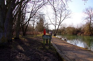
Port Meadow is a large meadow of open common land beside the River Thames to the north and west of Oxford, England.

Osney riverside community in the west of the city of Oxford, England

Osney or Osney Island is a riverside community in the west of the city of Oxford, England. In modern times the name is applied to a community also known as Osney Town astride Botley Road, just west of the city's main railway station, on an island surrounded by the River Thames, Osney Ditch and another backwater connecting the Thames to Osney Ditch.

Oxford Rewley Road railway station

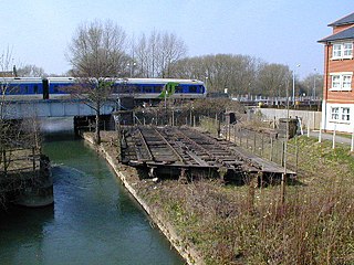
Oxford Rewley Road railway station was a railway station serving the city of Oxford, England, located immediately to the north of what is now Frideswide Square on the site of the Saïd Business School, to the west of Rewley Road. It was the terminus of the Buckinghamshire Railway, which was worked, and later absorbed, by the London and North Western Railway (L&NWR). In 1923 it became part of the London, Midland and Scottish Railway (LMS), "Varsity Line" service from Cambridge via Bletchley and had features of significance in construction history.

Osney Lock

Osney Lock is a lock on the River Thames in Oxford, England, where the village or island of Osney is next to the river.

River Don Navigation waterway navigation in South Yorkshire, England

The River Don Navigation was the result of early efforts to make the River Don in South Yorkshire, England, navigable between Fishlake and Sheffield. The Dutch engineer Cornelius Vermuyden had re-routed the mouth of the river in 1626, to improve drainage, and the new works included provision for navigation, but the scheme did not solve the problem of flooding, and the Dutch River was cut in 1635 to link the new channel to Goole. The first Act of Parliament to improve navigation on the river was obtained in 1726, by a group of Cutlers based in Sheffield; the Corporation of Doncaster obtained an Act in the following year for improvements to the lower river. Locks and lock cuts were built, and, by 1751, the river was navigable to Tinsley.

Fiddlers Island island in the River Thames at Oxford in England

Fiddler's Island is an island in the River Thames at Oxford in England. It is situated south of Port Meadow on the reach above Osney Lock.

Castle Mill Stream

Castle Mill Stream is a backwater of the River Thames in the west of Oxford, England. It is 5.5 km long.

Waterways, Oxford human settlement in United Kingdom

The Waterways is housing estate in North Oxford, England. The Oxford Canal runs through the centre of the estate and it is bounded on the east by the Cherwell Valley railway line. To the west beyond the railway line are Port Meadow and the River Thames. The estate begins in the south as a continuation of Frenchay Road, part of Victorian North Oxford, and as Elizabeth Jennings Way connects with the Woodstock Road (A4144) at the northern end of the estate.

Walton Well Road

Walton Well Road is a road, about 400 metres long, near the centre of Oxford, England. It provides a link from central Oxford to Port Meadow.

Aristotle Lane

Aristotle Lane is a road in north Oxford, England.

Bulstake Stream

Bulstake Stream, also spelt Bullstake Stream, is a backwater of the River Thames at Oxford, England.

Isis Lock

Isis Lock is a lock connecting the Oxford Canal and the Castle Mill Stream, a backwater of the River Thames in Oxford, England.
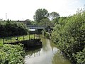
References

  1. 1 2 "Sheepwash Channel Railway Bridge". UK: CanalPlanAC . Retrieved 19 September 2012.External link in |publisher= (help)
  2. Woolley, Liz (2012). Oxford's Working Past. Huxley Scientific Press. pp. 6, 13–14. ISBN   978-0-9522671-7-1.External link in |publisher= (help)
  3. "Sheepwash Channel — Oxford Canal / River Thames". UK: Movable Bridges in the British Isles . Retrieved 15 September 2012.External link in |publisher= (help)