Pamidimukkala is a village in Krishna district of the Indian state of Andhra Pradesh. It is located in Pamidimukkala mandal of Nuzvid revenue division.
Zamigolvepalle is a village in Krishna district of the Indian state of Andhra Pradesh. It is located in Pamarru mandal.
Addada is a village in the southern state of Andhra Pradesh, India. It is located in the Pamarru taluk of Krishna district in Andhra Pradesh.
Nimmakuru is a village in Krishna district of the Indian state of Andhra Pradesh. It is located in Pamarru mandal of Gudivada revenue division. It is the birth place of former and the first non-Congress Chief Minister of Andhra Pradesh and Telugu film actor N.T.Rama Rao,his son and TDP charioteer Nandamuri Harikrishna and current MAA president Rajendra Prasad.
Kurumaddali is a village in Krishna District, Andhra Pradesh, India. It is situated on the Machilipatnam - Vijayawada highway, 1 km. from Pamarru towards Vijayawada and 10 km from Vuyyuru. Pamarru is a Mandal Headquarters and a Legislative Assembly constituency. Pammaru has become Legislative Assembly constituency in the delimitation process held prior to the 2009 general elections.

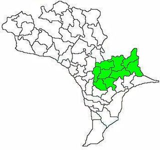
Chandarlapadu mandal is one of the 50 mandals in Krishna District of the Indian state of Andhra Pradesh. It is under the administration of Vijayawada revenue division and headquarters located at Chandarlapadu. The mandal is situated on the banks of Krishna River, bounded by Jaggayyapeta, Nandigama, Kanchikacherla mandals.
Pasumarru is a village in Krishna district of the Indian state of Andhra Pradesh. It is located in Pamarru mandal in Gudivada revenue division.
Bhatlapenumarru is a village in Krishna District of the Indian state of Andhra Pradesh. It is located in Movva mandal of Machilipatnam revenue division.

Vuyyuru mandal is one of the 50 mandals in Krishna district of the Indian state of Andhra Pradesh. It is under the administration of Nuzvid revenue division and the headquarters are located at Vuyyuru town. The mandal is bounded by Kankipadu, Unguturu, Thotlavalluru, Pedaparupudi and Pamidimukkala mandals.

Machilipatnam mandal is one of the 50 mandals in Krishna district of the Indian state of Andhra Pradesh. It is under the administration of Machilipatnam revenue division and the headquarters are located at Machilipatnam town. The mandal is bounded by Bantumilli, Pedana, Gudur, Ghantasala, Challapalli and Koduru mandals.

Gannavaram mandal is one of the 50 mandals in Krishna district of the Indian state of Andhra Pradesh. It is under the administration of Nuzvid revenue division and the headquarters are located at Gannavaram. The mandal is bounded by Agiripalle, Bapulapadu, Unguturu, Vijayawada (rural) and Kankipadu mandals. The mandal is also a part of the Andhra Pradesh Capital Region under the jurisdiction of APCRDA.

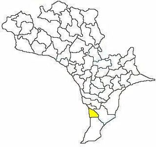
Nagayalanka mandal is one of the 50 mandals in Krishna district of the Indian state of Andhra Pradesh. It is under the administration of Machilipatnam revenue division and has its headquarters at Nagayalanka. The mandal is bounded by Avanigadda and Koduru mandals. It lies at the mouths of Krishna River where it empties into Bay of Bengal.

Gudivada mandal is one of the 50 mandals in Krishna district of the state of Andhra Pradesh in India. It is under the administration of Gudivada revenue division and the headquarters are located at Gudivada town. The mandal is bounded by Pedaparupudi, Nandivada, Mandavalli, Mudinepalle, Gudlavalleru, Pamarru mandals of Krishna district.
Avanigadda mandal is one of the 50 mandals in Krishna district of the Indian state of Andhra Pradesh. It is under the administration of Machilipatnam revenue division and the headquarters are located at Avanigadda. The mandal is bounded by Mopidevi, Koduru and Nagayalanka mandals.
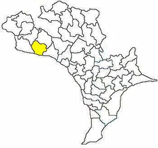
Kanchikacherla mandal is one of the 50 mandals in Krishna district of the Indian state of Andhra Pradesh. It is under the administration of Vijayawada revenue division and the headquarters are located at Kanchikacherla. The mandal is bounded Veerullapadu, Chanderlapadu and Ibrahimpatnam mandals. A portion of it lies on the banks of Krishna river, separating it from Guntur district and also Munneru river separates it from Nandigama mandal.

Pamarru Mandal is one of the 50 Mandals in Krishna district of the Indian state of Andhra Pradesh. It is under the administration of Gudivada revenue division and the headquarters are located at Pamarru. The mandal is bounded by Pamidimukkala, Pedaparupudi, Movva, Gudur, Gudlavalleru and Gudivada Mandals of Krishna District.