Vijayawada (rural) mandal

Last updated

Vijayawada (rural) mandal
Mandal

Vijayawada (rural) mandal in Krishna district.jpg

Mandal map of Krishna district showing Vijayawada (rural) mandal (in yellow)
Location map India Andhra Pradesh EN.svg
Red pog.svg
Vijayawada (rural) mandal
Location in Andhra Pradesh, India
Coordinates: 16°32′45″N80°34′12″E / 16.54583°N 80.57000°E / 16.54583; 80.57000 Coordinates: 16°32′45″N80°34′12″E / 16.54583°N 80.57000°E / 16.54583; 80.57000
Country India
State Andhra Pradesh
District Krishna
Headquarters Nunna
Population (2011) [1]
  Total 153,591
Languages
  Official Telugu
Time zone IST (UTC+5:30)

Vijayawada (rural) mandal is one of the 50 mandals in Krishna district of the Indian state of Andhra Pradesh. It is under the administration of Vijayawada revenue division and has its headquarters at Nunna. [2] [3] The mandal is bounded by Ibrahimpatnam, G. Konduru, Agiripalle, Gannavaram, Kankipadu, Penamaluru and Vijayawada (urban) mandals. [4] The mandal is also a part of the Andhra Pradesh Capital Region under the jurisdiction of APCRDA. [5]

Krishna district District of Andhra Pradesh in India

Krishna district is an administrative district in the Coastal Andhra region of the Indian state of Andhra Pradesh. Machilipatnam is the administrative headquarters and Vijayawada is the most populated city in the district. It has an area of 8,727 km2 (3,370 sq mi) and had a population of 45,29,009 as per 2011 census of India. It is bounded by West Godavari on the east, Bay of Bengal on the South, Guntur and Suryapet districts in the west and a portion of it also borders with the state of Telangana. Krishna District is formed from District of Rajahmundry in 1859, Guntur district was separated from Krishna in 1904 to form Krishna district which was further divided in 1925, to Krishna and West Godavari districts.Krishna district is the most developed district in Andhra Pradesh.

India Country in South Asia

India, also known as the Republic of India, is a country in South Asia. It is the seventh largest country by area and with more than 1.3 billion people, it is the second most populous country as well as the most populous democracy in the world. Bounded by the Indian Ocean on the south, the Arabian Sea on the southwest, and the Bay of Bengal on the southeast, it shares land borders with Pakistan to the west; China, Nepal, and Bhutan to the northeast; and Bangladesh and Myanmar to the east. In the Indian Ocean, India is in the vicinity of Sri Lanka and the Maldives, while its Andaman and Nicobar Islands share a maritime border with Thailand and Indonesia.

Andhra Pradesh State in southern India

Andhra Pradesh is one of the 29 states of India. Situated in the south-east of the country, it is the seventh-largest state in India, covering an area of 162,970 km2 (62,920 sq mi). As per the 2011 census, it is the tenth most populous state, with 49,386,799 inhabitants. The largest city in Andhra Pradesh is Visakhapatnam. Telugu, one of the classical languages of India, is the major and official language of Andhra Pradesh.

Contents

Demographics

As of 2011 census, the mandal had a population of 153,591. The total population constitute, 79,926 males and 73,665 females —a sex ratio of 922 females per 1000 males. 14,771 children are in the age group of 0–6 years, of which 7,699 are boys and 7,072 are girls. The average literacy rate stands at 80.09% with 111,181 literates. [1] Gollapudi is the most populated village and Vemavaram is the least populated village in the mandal. [6]

The decennial Census of India has been conducted 15 times, as of 2011. While it has been undertaken every 10 years, beginning in 1872, the first complete census was taken in 1881. Post 1949, it has been conducted by the Registrar General and Census Commissioner of India under the Ministry of Home Affairs, Government of India. All the censuses since 1951 were conducted under the 1948 Census of India Act. The last census was held in 2011. The next will be held in 2021.

Vemavaram Village in Andhra Pradesh, India

Vemavaram is a village in Krishna district of the Indian state of Andhra Pradesh. It is located in Vijayawada (rural) mandal.

Towns and villages

As of 2011 census, the mandal has 18 settlements. [2] On 23 March 2017, as per the G.O. 104 of Municipal Administration and Urban Development Department, Ambapuram, Done Atukuru, Enikepadu, Gollapudi, Gudavalli, Jakkampudi, Nidamanuru, Nunna, Pathapadu, Prasadampadu, Ramavarappadu became a part of Vijayawada metropolitan area. [7] [8]

Enikepadu Neighbourhood in Krishna, Andhra Pradesh, India

Enikepadu is a neighbourhood of Vijayawada in Krishna district of the Indian state of Andhra Pradesh. According to the G.O. No. M.S.104, Municipal Administration and Urban Development Department, the village became a part of Vijayawada metropolitan area.

Nidamanuru, Krishna district Neighbourhood in Krishna district, Andhra Pradesh, India

Nidamanuru is a neighbourhood of Vijayawada in Krishna district of the Indian state of Andhra Pradesh. It is located in Vijayawada (rural) mandal of Vijayawada revenue division. As per the G.O. No. M.S.104 (dated:23-03-2017), Municipal Administration and Urban Development Department, it became a part of Vijayawada metropolitan area.

Nunna Neighbourhood in Krishna, Andhra Pradesh, India

Nunna is a neighbourhood of Vijayawada in Krishna district of the Indian state of Andhra Pradesh. It is the headquarters of Vijayawada (rural) mandal in Vijayawada revenue division. As per the G.O. No. M.S.104 (dated:23-03-2017), Municipal Administration and Urban Development Department, it became a part of Vijayawada metropolitan area.The biggest Mango market in Asia, called Nunna Mango Market is located at Nunna. And 400 kv Vijayawada Power grid is also here. Polavaram Right Canal goes through Nunna. And State Capital Vijayawada-Amaravati Inner Ring Road is covering the Nunna.

The settlements in the mandal are listed below:

  1. Kothuru
  2. Paidurupadu
  3. Phiryadi Nainavaram (OG)
  4. Rayanapadu
  5. Shahabad
  6. Tadepalle
  7. Vemavaram

Note: M-Municipality, (CT)-Census town, OG-Out Growth [9]

Municipality An administrative division having corporate status and usually some powers of self-government or jurisdiction

A municipality is usually a single administrative division having corporate status and powers of self-government or jurisdiction as granted by national and regional laws to which it is subordinate. It is to be distinguished (usually) from the county, which may encompass rural territory or numerous small communities such as towns, villages and hamlets.

A census town is a type of town that satisfies certain characteristics, depending on the country in which it is located.

See also

Vijayawada revenue division

Vijayawada revenue division is an administrative division in the Krishna district of the Indian state of Andhra Pradesh. It is one of the 4 revenue divisions in the district with 15 mandals under its administration. Vijayawada serves as the headquarters of the division. The division has 1 municipality and 1 municipal corporation.

Related Research Articles

Gannavaram Neighbourhood in Krishna, Andhra Pradesh, India

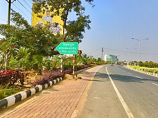
Gannavaram is a neighbourhood of Vijayawada in Krishna district of the Indian state of Andhra Pradesh. As per the G.O. No. M.S.104 (dated:23-03-2017), Municipal Administration and Urban Development Department, it became a part of Vijayawada metropolitan area. It is also the mandal headquarters of Gannavaram mandal, administered under Nuzvid revenue division.

Kanuru Neighbourhood in Krishna, Andhra Pradesh, India

Kanuru is a neighbourhood of Vijayawada in Krishna district of the Indian state of Andhra Pradesh.It is a education hub. It is located in Penamaluru mandal of Vijayawada revenue division. As per the G.O. No. M.S.104 (dated:23-03-2017), Municipal Administration and Urban Development Department, it became a part of Vijayawada metropolitan area.

Mopidevi Village in Andhra Pradesh, India

Mopidevi is a village in Krishna district of the Indian state of Andhra Pradesh. It is the mandal headquarters of Mopidevi mandal in Machilipatnam revenue division. It is one of the villages in the mandal to be a part of Andhra Pradesh Capital Region.

Penamaluru Neighbourhood in Krishna, Andhra Pradesh, India

Penamaluru is a neighbourhood of Vijayawada in Krishna district of the Indian state of Andhra Pradesh. It is the mandal headquarters of Penamaluru mandal in Vijayawada revenue division. As per the G.O. No. M.S.104 (dated:23-03-2017), Municipal Administration and Urban Development Department, it became a part of Vijayawada metropolitan area.

Thotlavalluru mandal Mandal in Andhra Pradesh, India

Thotlavalluru mandal is one of the 50 mandals in Krishna district of the Indian state of Andhra Pradesh. It is under the administration of Vijayawada revenue division and its headquarters are located at North Valluru. The mandal lies on the banks of Krishna River and is bounded by Kankipadu, Vuyyuru and Pamidimukkala mandals. The mandal is also a part of the Andhra Pradesh Capital Region under the jurisdiction of APCRDA.

Tadepalle, Krishna district Village in Andhra Pradesh, India

Tadepalle is a village in Krishna district of the Indian state of Andhra Pradesh. It is located in Vijayawada Rural mandal of Vijayawada revenue division. It is one of the villages in the mandal to be a part of Andhra Pradesh Capital Region.

Gollapudi, Vijayawada Neighbourhood in Krishna, Andhra Pradesh, India

Gollapudi is a neighbourhood of Vijayawada in Krishna district of the Indian state of Andhra Pradesh. It is located in Vijayawada (rural) mandal of Vijayawada revenue division. As per the G.O. No. M.S.104 (dated:23-03-2017), Municipal Administration and Urban Development Department, it became a part of Vijayawada metropolitan area.

Ramavarappadu Neighbourhood in Krishna, Andhra Pradesh, India

Ramavarappadu is a neighbourhood of Vijayawada in Krishna district of the Indian state of Andhra Pradesh. It is located in Vijayawada (rural) mandal of Vijayawada revenue division. As per the G.O. No. M.S.104 (dated:23-03-2017), Municipal Administration and Urban Development Department, it became a part of Vijayawada metropolitan area.

Poranki Neighbourhood in Krishna, Andhra Pradesh, India

Poranki is a neighbourhood of Vijayawada in Krishna district of the Indian state of Andhra Pradesh. It is located in Penamaluru mandal of Vijayawada revenue division. As per the G.O. No. M.S.104 (dated:23-03-2017), Municipal Administration and Urban Development Department, it became a part of Vijayawada metropolitan area. It is 2 KM from Penamaluru.

Chandarlapadu mandal Mandal in Andhra Pradesh, India

Chandarlapadu mandal is one of the 50 mandals in Krishna District of the Indian state of Andhra Pradesh. It is under the administration of Vijayawada revenue division and headquarters located at Chandarlapadu. The mandal is situated on the banks of Krishna River, bounded by Jaggayyapeta, Nandigama, Kanchikacherla mandals.

Ganguru is a neighbourhood of Vijayawada in Krishna district of the Indian state of Andhra Pradesh. As per the G.O. No. M.S.104 (dated:23-03-2017), Municipal Administration and Urban Development Department, it became a part of Vijayawada metropolitan area. It is located in Penamaluru mandal of Vijayawada revenue division.

Chitturpu Village in Andhra Pradesh, India

Chitturpu is a village in Krishna district of the Indian state of Andhra Pradesh. It is located in Ghantasala mandal of Vijayawada revenue division. It is one of the villages in the mandal to be a part of Andhra Pradesh Capital Region.

Gannavaram mandal Mandal in Andhra Pradesh, India

Gannavaram mandal is one of the 50 mandals in Krishna district of the Indian state of Andhra Pradesh. It is under the administration of Nuzvid revenue division and the headquarters are located at Gannavaram. The mandal is bounded by Agiripalle, Bapulapadu, Unguturu, Vijayawada (rural) and Kankipadu mandals. The mandal is also a part of the Andhra Pradesh Capital Region under the jurisdiction of APCRDA.

Ibrahimpatnam mandal, Krishna district Mandal in Andhra Pradesh, India

Ibrahimpatnam mandal is one of the fifty mandals that constitute the Krishna district of the State of Andhra Pradesh in India. It is under the administration of the Vijayawada revenue division and the mandal headquarters are located at Ibrahimpatnam town. The mandal is located on the banks of Krishna River and is bounded by Kanchikacherla, Veerullapadu, G. Konduru and Vijayawada (rural) mandals. The mandal is also a part of the Andhra Pradesh Capital Region under the jurisdiction of APCRDA.

Penamaluru mandal Mandal in Andhra Pradesh, India

Penamaluru mandal is one of the 50 mandals in Krishna district of the Indian state of Andhra Pradesh. It is under the administration of Vijayawada revenue division and its headquarters are located at Penamaluru. The mandal lies on the banks of Krishna River and is bounded by Vijayawada (urban), Vijayawada (rural) and Kankipadu mandals. The mandal is also a part of the Andhra Pradesh Capital Region under the jurisdiction of APCRDA.

Chillakallu Town in Andhra Pradesh, India

Chillakallu is a village in Krishna district of the Indian state of Andhra Pradesh. It is located in Jaggayyapeta mandal of Vijayawada revenue division. It is one of the villages in the mandal to be a part of Andhra Pradesh Capital Region. It is located on National Highway 9 that connects Hyderabad and Vijayawada.

Nandigama mandal Mandal in Andhra Pradesh, India

Nandigama mandal is one of the 50 mandals in Krishna district of the Indian state of Andhra Pradesh. It is under the administration of Vijayawada revenue division and the headquarters are located at Nandigama. The mandal is bounded Penuganchiprolu, Kanchikacherla, Chandarlapadu mandals and also a portion of it by the state of Telangana.

Prasadampadu Neighbourhood in Krishna, Andhra Pradesh, India

Prasadampadu is a neighbourhood of Vijayawada in Krishna district of the Indian state of Andhra Pradesh. It is located in Vijayawada (rural) mandal of Vijayawada revenue division. As per the G.O. No. M.S.104 (dated:23-03-2017), Municipal Administration and Urban Development Department, it became a part of Vijayawada metropolitan area.

References

  1. 1 2 "Census 2011". The Registrar General & Census Commissioner, India. Retrieved 11 September 2014.
  2. 1 2 "Krishna District Mandals" (PDF). Census of India. pp. 494,526. Retrieved 21 January 2015.
  3. "Administrative Setup". Krishna District Official Website. Retrieved 15 October 2014.
  4. "Mandals in Krishna district". aponline.gov.in. Archived from the original on 13 December 2014. Retrieved 28 July 2014.
  5. "Andhra Pradesh Capital Region Development Authority Act, 2014" (PDF). News19. Municipal Administration and Urban Development Department. 30 December 2014. Archived from the original (PDF) on 18 February 2015. Retrieved 9 February 2015.
  6. "Sub-District Details of Krishna District". censusindia.gov.in. Archived from the original on 18 July 2014. Retrieved 11 September 2014.
  7. Reporter, Staff. "Vijayawada, 19 other contiguous areas notified as Metropolitan Area". The Hindu. Retrieved 27 March 2017.
  8. "Welcome to Government Order Issue Register". goir.ap.gov.in. Retrieved 27 March 2017.
  9. "Some Concepts and Definitions" (PDF). Census of India 2011. Retrieved 19 January 2015.