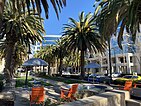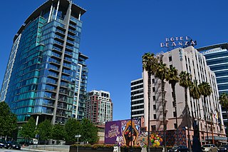
San Jose, officially the City ofSan José, is the cultural, financial, and political center of Silicon Valley, and the largest city in Northern California by both population and area.
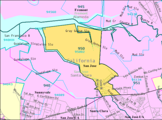
Alviso is a neighborhood in San Jose, Santa Clara County, California, and until 1968, it was an independent city of the same name. It is at the north end of San José where it meets the southern end of the San Francisco Bay and borders the cities of Milpitas, Sunnyvale, and Santa Clara.
Interstate 880 (I-880) is a north–south auxiliary Interstate Highway in the San Francisco Bay Area of Northern California. It runs from I-280 and State Route 17 (SR 17) in San Jose to I-80 and I-580 in Oakland, running parallel to the eastern shore of San Francisco Bay. For most of its route, I-880 is officially known as the Nimitz Freeway, after World War II fleet admiral Chester Nimitz, who retired to the Bay Area and lived on Yerba Buena Island. The northernmost five miles is also commonly referred to as the Cypress Freeway, after the former alignment of the freeway, and its subsequent replacement.

State Route 85, known as the West Valley Freeway along its entire length, is a state highway which connects the cities of southern San Jose and Mountain View in the U.S. State of California. The highway intersects with major highways such as I-280, SR 17, and SR 87. The route provides an alternate to U.S. Route 101, bypassing downtown San Jose and instead passing through the foothill cities of Los Gatos, Saratoga, Cupertino, and other cities in the southern San Francisco Peninsula, roughly paralleling the Santa Cruz Mountains up to its interchange with I-280.

The Guadalupe River mainstem is an urban, northward flowing 14 miles (23 km) river in California whose much longer headwater creeks originate in the Santa Cruz Mountains. The river mainstem now begins on the Santa Clara Valley floor when Los Alamitos Creek exits Lake Almaden and joins Guadalupe Creek just downstream of Coleman Road in San Jose, California. From here it flows north through San Jose, where it receives Los Gatos Creek, a major tributary. The Guadalupe River serves as the eastern boundary of the City of Santa Clara and the western boundary of Alviso, and after coursing through San José, it empties into south San Francisco Bay at the Alviso Slough.

State Route 87, known as the Guadalupe Freeway, is a north–south state highway in San Jose, California, United States. Before being upgraded to a freeway, it was Guadalupe Parkway.

State Route 237 is a state highway in the U.S. state of California that runs from El Camino Real in Mountain View to Interstate 680 in Milpitas. Known as the Southbay Freeway for most of its length, SR 237 runs south of the San Francisco Bay, connecting the East Bay to the Peninsula.
Pablo Vicente de Solá (1761–1826) was a Spanish officer and the twelfth and last Spanish colonial governor of Alta California (1815-1822). He was born in Mondragón, Gipuzkoa, Spain.

Rancho Rincón de los Esteros was a 6,353-acre (25.71 km2) Mexican land grant in present-day Santa Clara County, California.

Juan Ignacio Alviso (1772–1848) was a Californio ranchero and soldier. He is the namesake of Alviso, a neighborhood of the city of San Jose, California.

The history of San Jose, California, the third largest city in the state, and the largest of all cities in the San Francisco Bay Area and Northern California, with a population of 1,021,795:
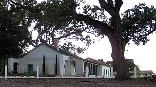
The Alviso Adobe Community Park is a 7-acre (2.8 ha) park in the city of Pleasanton, California, United States. It is built around an adobe house constructed in 1854 by Francisco Alviso on the Rancho Santa Rita Mexican Land Grant. The Alviso Adobe is a rare surviving example of an early American adobe that was continuously in use until 1969. The building is registered as California Historical Landmark #510 in 1954, but most of the historical marker was later found to be erroneous.
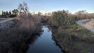
The Guadalupe River Trail is an 11-mile (18 km) pedestrian and bicycle path in the city of San Jose, California. The path runs along the banks of the Guadalupe River. The trail is currently composed of two discontinuous segments: a short segment along the Upper Guadalupe River and a longer segment along the Lower Guadalupe River. This trail is heavily used for both recreation and commuting, as it provides direct access to Downtown San Jose from many of the outlying neighborhoods. The trail is paved.

Milpitas is a city in Santa Clara County, California, in Silicon Valley. The population was estimated to be 84,169 in 2019 by the US Census. The city's origins lie in the Rancho Milpitas, granted to Californio ranchero José María Alviso in 1835. Milpitas incorporated in 1954 and has since become home to numerous high tech companies, as part of Silicon Valley.
Rancho Cholame was a 26,622-acre (107.74 km2) Mexican land grant in present-day Monterey County and San Luis Obispo County, California given in 1844 by Governor Manuel Micheltorena to Mauricio Gonzales. The grant extended along the Cholame Valley, and encompassed present day Cholame.
Rancho Pala was a 4,454-acre (18.02 km2) Mexican land grant in present day Santa Clara County, California given in 1835 by Governor José Castro to José Joaquín Higuera. The origin of the name is the subject of debate. The word "pala" translates as "shovel" in Spanish, but means "water", in many native American dialects. The grant was a narrow strip of land east of San Jose, and extending southward along the foothills from Penitencia Creek to Norwood Avenue.

Rincon de los Esteros, also known as Innovation Triangle, the Golden Triangle, the Innovation District, or simply as Rincon, is a vast district of San Jose, California, making up a significant portion of North San Jose. The district has one of the largest concentrations of high tech company headquarters and campuses in Silicon Valley.

North San Jose is the northern region of San Jose, California in Silicon Valley. North San Jose includes the communities of Alviso and Berryessa as well as the North San Jose Innovation District. It lends its name to the Berryessa/North San Jose BART station.

Riverview Park is a park in San Jose, California, located along the Guadalupe River in the Rincon district of North San Jose

Tamien is a neighborhood of central San Jose, California, in Silicon Valley. The neighborhood is centered around Tamien Station, one of San Jose's most important transit stations.

