
Tirana is the capital and largest city of Albania. It is located in the centre of the country, enclosed by mountains and hills, with Dajti rising to the east and a slight valley to the northwest overlooking the Adriatic Sea in the distance. It is among the wettest and sunniest cities in Europe, with 2,544 hours of sun per year.

Tourism in Albania has been a key element to the country's economic activity and is constantly developing. Albania is characterized by its rich archaeological and cultural heritage dating back to the classical period when Illyrians and Ancient Greeks inhabited the region. Over the course of history, the territory of Albania was occupied and populated by Romans, Byzantines, Venetians and Ottomans. Notably the country features unspoiled beaches, mountainous landscapes, traditional cuisine, archaeological artifacts, unique traditions, low prices and the wild atmosphere of the countryside.

Telford Gardens is a private housing estate located above the MTR Kowloon Bay Depot and alongside Kowloon Bay station in Kowloon Bay, Kowloon, Hong Kong. It was jointly built by Hang Lung Properties and Hopewell Holdings, and Telford Plaza II was built by New World Development. Being the first property development project of the Mass Transit Railway, the estate is now managed by the corporation. The address of Telford Gardens is 33 Wai Yip Street, Kowloon Bay, Kowloon, Hong Kong.
Mother Teresa of Kolkata has been memorialized throughout the world in recognition of her work with the poor. During her lifetime this commemoration often took the form of awards and honorary degrees bestowed upon her. She has also been memorialized through museums and dedications of churches, roads and other structures.
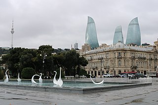
Baku Boulevard is a promenade established in 1909 which runs parallel to Baku's seafront. Its history goes back more than 100 years, to a time when Baku oil barons built their mansions along the Caspian shore and when the seafront was artificially built up inch by inch.

The Skanderbeg Square is the main plaza in the centre of Tirana, Albania. The square is named after the Albanian national hero Gjergj Kastrioti Skënderbeu. The total area is about 40,000 square metres. The Skanderbeg Monument dominates the square.

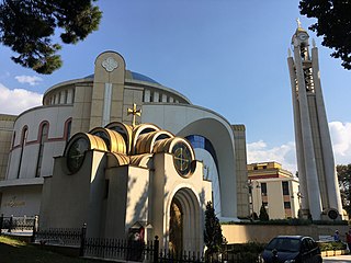
The Sacred Heart Church is a Roman Catholic church in Tirana, Albania. Built in 1939 during the Italian invasion of Albania, it is the oldest Catholic church in the city.

The Dëshmorët e Kombit Boulevard is a major thoroughfare in Tirana, Albania. It was initially designed by Armando Brasini in 1925. Brasini's master plan was later amended by Florestano di Fausto, and in 1939 by Gherardo Bosio following the Italian invasion of Albania.

Tirana railway station was the central railway hub of Tirana, Albania. The railway was connected to other cities in Albania including Vlorë and Durrës. The railway station was said to have no luggage office. On 2 September 2013, the station was closed for passenger and freight transport, and was demolished to make room for a new boulevard that leads over the station area to the north. A completely new district will be created. As a result, the Tirana station was moved to Vorë in 2013, and later to renovated Kashar station in May 2015. The former Kashar-Tiranë line around 10 km in length was replaced with a bus service.

Bajram Curri Boulevard is a major boulevard of Tirana, Albania. It runs in a west–east direction and crosses the city centre south of the central Skanderbeg Square. At Rinia Park it intersects with Dëshmorët e Kombit Boulevard just south of the square. Towards the east it branches off into Ali Demi Street. In the past, it held the name Shqiperia e Re. The boulevard, along with Zhan D'Ark Boulevard, underwent reconstruction in 2003.

The Zogu I Boulevard or Boulevard Zog I was the first and the only boulevard at that time and is a major boulevard in Tirana, Albania, named after Zog I of Albania, the King of Albania who ruled the country between 1925 and 1939.

Kavajë Street is a major street of Tirana, Albania. It is the most important street of western Tirana and runs west from the central Skanderbeg Square for several kilometres and continues further west to the Adriatic Sea. It is known for its prime real estate and some of the most expensive residential apartments in Tirana. The Universal Hospital Tirana is located along this street. It intersects with Bajram Curri Boulevard.
Dibër Street is a major street in Tirana, Albania. It runs northeast from the central Skanderbeg Square, just south of the Tirana International Hotel. The Mother Teresa Hospital (QSUT) is located on this street.
Ali Demi Street is a major street of Tirana, Albania. It is named after Ali Demi, a World War II hero. It is an important central street of eastern Tirana and branches off the Bajram Curri Boulevard. Several universities and colleges are located along this street. In this street is located the Ministry of Foreign Affairs.

Taivani or the Taiwan Center, is a restaurant complex, as well as a multifunctional recreation center located in Rinia Park, just south of Skanderbeg Square in downtown Tirana, Albania. Taivani is one of Tirana's most modern and frequented restaurants and spare time facilities. It also includes a well-equipped bowling center. It is known as Taivani or "Taiwan" as it is said to resemble a small island, in the middle of a park.
The Ali Demi neighborhood is a neighborhood located in Tirana, Albania.

Durrës Street is a major street of Tirana, Albania. It is one of the most important street of western Tirana and runs west from the central Skanderbeg Square for several kilometres until it reaches the sea to the north of Durrës.
Hotel Dajti was a hotel near Rinia Park on Dëshmorët e Kombit Boulevard in central Tirana, Albania. Carrying the name of nearby Dajti Mountain, it was the primary center for international visitors and diplomats during Albania's socialist period; the guest rooms were bugged with microphones, and there was a sub-basement floor for listening staff.
The Culture of Tirana concerns the arts, music, museums, festivals and other entertainment in the capital city of Albania. Tirana is one of the country's leading business and cultural centers including entertainment, music, media, fashion, and the arts all contribute to its status as Albania's largest city.
There are many landmarks in Tirana, Albania some of which are of considerable historical or artistic interest. Many monuments and landmarks situated in Tirana, date back to the Illyrian, Roman, Greek and Ottoman periods.


