
The River Severn, at 220 miles (354 km) long, is the longest river in Great Britain. It is also the river with the most voluminous flow of water by far in all of England and Wales, with an average flow rate of 107 m3/s (3,800 cu ft/s) at Apperley, Gloucestershire. It rises in the Cambrian Mountains in mid Wales, at an altitude of 2,001 feet (610 m), on the Plynlimon massif, which lies close to the Ceredigion/Powys border near Llanidloes. The river then flows through Shropshire, Worcestershire and Gloucestershire. The county towns of Shrewsbury, Gloucester and the City of Worcester lie on its course.

The River Welland is a lowland river in the east of England, some 65 miles (105 km) long. It drains part of the Midlands eastwards to The Wash. The river rises in the Hothorpe Hills, at Sibbertoft in Northamptonshire, then flows generally northeast to Market Harborough, Stamford and Spalding, to reach The Wash near Fosdyke. It is a major waterway across the part of the Fens called South Holland, and is one of the Fenland rivers which were laid out with washlands. There are two channels between widely spaced embankments with the intention that flood waters would have space in which to spread while the tide in the estuary prevented free egress. However, after the floods of 1947, new works such as the Coronation Channel were constructed to control flooding in Spalding and the washes are no longer used solely as pasture, but may be used for arable farming.

The River Great Ouse is a river in England, the longest of several British rivers called "Ouse". From Syresham in Northamptonshire, the Great Ouse flows through Buckinghamshire, Bedfordshire, Cambridgeshire and Norfolk to drain into the Wash and the North Sea near Kings Lynn. With a course of about 143 miles (230 km), mostly flowing north and east, it is the fifth longest river in the United Kingdom. The Great Ouse has been historically important for commercial navigation, and for draining the low-lying region through which it flows; its best-known tributary is the Cam, which runs through Cambridge. Its lower course passes through drained wetlands and fens and has been extensively modified, or channelised, to relieve flooding and provide a better route for barge traffic. The unmodified river would have changed course regularly after floods.
The River Lark is a river in England that crosses the border between Suffolk and Cambridgeshire. It is a tributary of the River Great Ouse, and was extended when that river was re-routed as part of drainage improvements. It is thought to have been used for navigation since Roman times, and improvements to its navigability were made in 1638 and in the early 18th century, when locks and staunches were built. The upper terminus was on the northern edge of Bury St Edmunds, but a new dock was opened near the railway station after the Eastern Union Railway opened its line in 1846.
The River Little Ouse is a river in the east of England, a tributary of the River Great Ouse. For much of its length it defines the boundary between Norfolk and Suffolk.
The River Dane is a tributary of the River Weaver that originates in the Peak District area of England. The name of the river is probably from the Old Welsh dafn, meaning a "drop or trickle", implying a slow-moving river.
The Neversink River is a 55-mile-long (89 km) tributary of the Delaware River in southeastern New York in the United States. The name of the river comes from the corruption of an Algonquian language phrase meaning "mad river."

The Hogsmill River in Surrey and Greater London, England is a small chalk stream tributary of the River Thames. It rises in Ewell and flows into the Thames at Kingston upon Thames on the lowest non-tidal reach, that above Teddington lock.

Moulton is a village and civil parish in the West Suffolk district of Suffolk in eastern England, located close to the town of Newmarket. It pre-dates the 1086 Domesday book and, in 2005, it was estimated to have a population of 1090. 1,033 people were recorded at the 2011 census.

The Missisquoi River is a transboundary river of the east shore of Lake Champlain, approximately 80 miles (130 km) long, in northern Vermont in the United States and southern Quebec in Canada.

Chippenham is a village and civil parish in Cambridgeshire, England, part of East Cambridgeshire district around 4 miles (6.4 km) north-east of Newmarket and 10 miles (16 km) north-east of Cambridge.

The River Penk is a small river flowing through Staffordshire, England. Its course is mainly within South Staffordshire, and it drains most of the northern part of that district, together with some adjoining areas of Cannock Chase, Stafford, Wolverhampton, and Shropshire. It flows into the River Sow, which is a tributary of the River Trent, so its waters flow ultimately into the North Sea via the Humber Estuary.

Blow-me-down Brook is a 12.8-mile (20.6 km) long stream located in western New Hampshire in the United States. It is a tributary of the Connecticut River, which flows to Long Island Sound.
Stour Brook is a river that starts north west of the town of Haverhill, Suffolk just over the Cambridgeshire border in the parish of West Wickham. After leaving Haverhill, it quickly joins the River Stour by the village of Wixoe, Essex. During its course through Haverhill, most of the natural channel of this river has been replaced with a concrete channel.

Kennett is a small village and civil parish at the very eastern tip of Cambridgeshire, England. Situated around 2.5 miles (4.0 km) north-east of Newmarket and 4 miles (6.4 km) north-west of Bury St Edmunds, it falls into the district of East Cambridgeshire.
Lackford was a hundred of Suffolk, consisting of 83,712 acres (338.77 km2).

Moulton was a rural district in Suffolk, England from 1894 to 1935. It covered the area to the east of the town of Newmarket.
Landwade is a parish in Suffolk, England, four miles north of Newmarket. One of the smallest parishes in the county, it is only 1 kilometre from north to south and at most 500m from east to west.
The Cut-off Channel is a man-made waterway which runs along the eastern edge of the Fens in Norfolk and Suffolk, England. It was constructed in the 1950s and 1960s as part of flood defence measures, and carries the headwaters of the River Wissey, River Lark and River Little Ouse in times of flood, delivering them to Denver Sluice on the River Great Ouse. In the summer months, it is also used as part of a water supply scheme for drinking water in Essex.

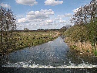
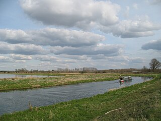
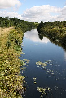
 River Kennett at Badlingham, near Chippenham, Cambridgeshire
 The 15th-century Moulton Packhorse Bridge


