
The Quad Cities is a region of five cities in the U.S. states of Iowa and Illinois: Davenport and Bettendorf in southeastern Iowa, and Rock Island, Moline, and East Moline in northwestern Illinois. These cities are the center of the Quad Cities metropolitan area, which as of 2013 had a population estimate of 383,781 and a CSA population of 474,937, making it the 90th largest CSA in the nation.

Scott County is a county located in the U.S. state of Iowa. As of the 2010 census, the population was 165,224, making it the third-most populous county in Iowa. The county seat is Davenport.

Riverdale is a city in Scott County, Iowa, United States. The population was 405 at the 2010 census.
The East Coast Greenway is a 3,000-mile (4,800 km) biking and walking route linking the major cities of the Atlantic coast of the United States, from Calais, Maine, to Key West, Florida. The spine route and branching complementary routes are for non-motorized human transportation for everything from local commutes to long-distance trips.

The Mount Vernon Trail (MVT) is a 17 miles (27 km) long paved bicycle and pedestrian path in Northern Virginia between Rosslyn and George Washington's home at Mount Vernon. The trail connects the easternmost portions of Arlington County, the City of Alexandria, and Fairfax County, and travels mostly on dedicated trail with a small portion on city streets. As part of U.S. Bike Route 1, the MVT opened in April 1972 as a gravel path and was subsequently expanded and paved.
The Brooklyn–Queens Greenway is a bicycling and pedestrian path connecting parks and roads in the New York City boroughs of Brooklyn and Queens, connecting Coney Island in the south to Fort Totten in the north, on Long Island Sound. The route connects major sites in the two boroughs, such as the New York Aquarium, Brooklyn Museum, the Brooklyn Botanic Garden, the New York Hall of Science and Citi Field.

The Village of East Davenport, also known simply as The Village, is located along the Mississippi River on the southeast side of Davenport, Iowa, United States. It was listed as a historic district on the National Register of Historic Places in 1980 as the Davenport Village. At the time of its nomination it included 145 contributing properties, most of which were working-class housing.

Duck Creek is a minor tributary of the Mississippi River in the United States. The creek runs through Scott County, Iowa, and the cities of Davenport, Bettendorf, and Riverdale.

Lindsay Park is a 31-acre (0.13 km2) park. located in the Village of East Davenport in Davenport, Iowa, United States. The lower park is a contributing property of the Davenport Village Historic District that has been listed on the National Register of Historic Places since 1980, and the upper park is part of the McClellan Heights Historic District which was listed on the national register in 1984. The whole park was individually listed on the Davenport Register of Historic Properties in 1998. Lindsay Park is owned by the city of Davenport and features a playground, baseball diamonds and views of the Mississippi River, which is immediately to the south of the park. There is a group of architectural sculptures along the Riverfront Parkway, of which Lindsay Park is a part. The park also hosts the annual Riverssance Festival of Fine Art.

LeClaire Park is a public park located along the Mississippi River in downtown Davenport, Iowa, United States. It is situated between two other riverfront parks: Centennial Park on the west and River Heritage Park, a new park that is being developed to the east. The 400-acre (1.6 km2) park includes monuments, a bandshell. a baseball stadium and it is one of the terminal points for the Davenport Skybridge. The Riverfront Parkway pass through the park. Other features of the park include picnic shelters, horseshoe pits and river access for fishing. Moored off the park’s levee is a riverboat casino.

Centennial Park is one of four parks located along the Mississippi River in downtown Davenport, Iowa, United States. The other three are LeClaire Park, which is immediately to the east of Centennial Park, Veterans Memorial Park, which is being developed immediately to the west, and River Heritage Park that is under development on the far east side of downtown. Development of the 250-acre (1.0 km2) park was begun in 2000. Its name is derived from the Rock Island Centennial Bridge, which is on the east side of the park. Centennial Park features a boat ramp, a playground, a gazebo, fishing areas, a dog off leash area, basketball courts, a sprayground, and a skateboard park. The skate board park is used for skateboarding, roller blades and BMX bikes. The Riverfront Parkway passes through the park, and the River’s Edge, an indoor sports complex operated by Davenport Parks and Recreation, is on the northeast corner of the park.

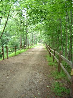
Duck Creek Parkway is located in the cities of Davenport and Bettendorf in the U.S. state of Iowa. The parkway is 13.5 miles (21.7 km) long and passes through multiple parks as it makes its way along Duck Creek. The parkway is the oldest recreational trail in the Quad Cities and has its roots in the 1930s when the first section was built as a park road. The present design for the parkway and the bike path date from the 1970s. It begins at Emeis Park and Golf Course on the west side of Davenport and passes through Northwest Park, Marquette Park, Junge Park, Garfield Park, Eastern Avenue Park and Duck Creek Park and Golf Course where it enters Bettendorf. In Bettendorf it travels through Middle Park, Veterans Memorial Park and Devils Glen Park before it comes to an end. The parkway stretches 8.36 miles (13.45 km) in Davenport and 5.14 miles in Bettendorf. There are plans to connect the parkway and recreational trail with the Riverfront Parkway and Sunderbruch Park.
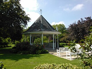
Duck Creek Park and Golf Course is located on the east side of Davenport, Iowa, United States. The property was originally a private arboretum south of Duck Creek. It was developed in the 1930s as a public works project during the Great Depression. The 211-acre (0.85 km2) park features picnic shelters, tennis courts, playground, a public golf course and Duck Creek Lodge. The Stampe Lilac Garden and Gazebo is a popular location for weddings. The park connects with the Duck Creek Parkway.

Sunderbruch Park is a 134-acre (0.54 km2) park located in the west end of Davenport, Iowa, United States. The park is largely undeveloped and consists of three different trail systems: hiking, off road biking and equestrian. The off road biking trails includes difficulty ranging from green to black diamond in its seven mile (11.2 km) system. The green trails are two miles (3.2 km) of wooded scenery. It features a few small log crossings, one ladder bridge and one corduroy feature. The blue trails provide moderate changes in elevation, some rooted and off-camber terrain and a variety of corduroy sections and log crossings. The black trails have more challenging ascents and descents in elevation, creek crossings, narrow winding trails, roots, skinnies, drops and multiple log crossings. In addition to the biking trails there are also 4.5 miles (7.24 km) of equestrian trails.

Fejervary Park is located in the west end of Davenport, Iowa, United States. The 75-acre (0.30 km2) park is dominated by rolling green grass hills and trees. It features play ground equipment and an aquatic center. The Putnam Museum is located just to the east of the park.
U.S. Highway 67 (US 67) is a U.S. Highway in extreme eastern Iowa. The route begins in Davenport at the Rock Island Centennial Bridge where it crosses the Mississippi River and ends at an intersection with US 52 and Iowa Highway 64 (Iowa 64) west of Sabula. It passes through Bettendorf, Le Claire, and Clinton. Except for Folletts, every community which US 67 enters sits along the Mississippi River. As such, the entire route is part of the Great River Road, an All-American Road.
Interstate 74 (I-74) is the central freeway through the Iowa Quad Cities. It roughly divides Davenport to the west and Bettendorf to the east. The Interstate Highway begins at an interchange with Interstate 80 (I-80) at the northeastern edge of Davenport and continues into Illinois at the Mississippi River by crossing the I-74 Bridge. The freeway was built in stages during the late 1960s and early 1970s.

Veterans Memorial Park is one of four parks located along the Mississippi River in downtown Davenport, Iowa, United States. The other three are Centennial Park, which is immediately to the east of Veterans Park, LeClaire Park and River Heritage Park, which is being developed on the far east side of downtown on land that had been used for industrial purposes. The Riverfront Parkway passes through the south side of the park.


