
Dehradun, also known as Dehra Doon, is the capital and the most populous city of the Indian state of Uttarakhand. It is the administrative headquarters of the eponymous district and is governed by the Dehradun Municipal Corporation, with the Uttarakhand Legislative Assembly holding its winter sessions in the city as its winter capital. Part of the Garhwal region, and housing the headquarters of its Divisional Commissioner, Dehradun is one of the "Counter Magnets" of the National Capital Region (NCR) being developed as an alternative centre of growth to help ease the migration and population explosion in the Delhi metropolitan area and to establish a smart city in the Himalayas.
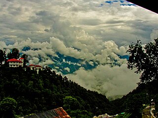
Mussoorie is a hill station and a municipal board, in Dehradun city in the Dehradun district of the Indian state Uttarakhand. It is about 35 kilometres (22 mi) from the state capital of Dehradun and 290 km (180 mi) north of the national capital of New Delhi. The hill station is in the foothills of the Garhwal Himalayan range. The adjoining town of Landour, which includes a military cantonment, is considered part of "greater Mussoorie", as are the townships Barlowganj and Jharipani.

Haldwani is the largest city of Kumaon. It is also the third most populous city and largest commercial market in the Indian state of Uttarakhand. Haldwani is said to be the financial capital of Uttarakhand, having the most commercial, economic and industrial activities of the state. Haldwani is located in the Nainital District, and is one of its eight Subdivisions. The Haldwani Urban agglomeration has 232,060 people as of 2011, and is the third most populous UA in Uttarakhand, after Dehradun and Haridwar. Being situated in the immediate foothills of Kumaon Himalayas, the Kathgodam neighbourhood of Haldwani is known as the "Gateway to Kumaon".
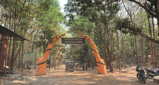
Kanger Valley National Park is a national park in the Bastar region of Chhattisgarh state in India. It came into existence in July 1982 and covers an area of approximately 200 square kilometres (77 sq mi). The park extends from the Teerathagarh waterfalls in the west to the Kolab river in the east, spanning an average length of 33.5 km (20.8 mi) and an average width of 6 km (3.7 mi) from north to south. It derives its name from the Kanger river, which flows centrally through it. Situated at a distance of 30 km (19 mi) southeast of Jagdalpur city, it is one of India's densest national parks and is known for its biodiversity, landscape, waterfalls, and subterranean geomorphologic limestone caves. It is also the home to the Bastar hill myna, the state bird of Chhattisgarh.
Chakrata is a cantonment town and also a sub district/tehsil, in Dehradun district in the state of Uttarakhand, India.
Dehradun district is a district in Garhwal which is a part of Uttarakhand state in northern India. The district headquarters is Dehradun, which has also served as the interim capital of Uttarakhand since its founding in 2000. The district has 6 tehsils, 6 community development blocks, 17 towns and 764 inhabited villages, and 18 unpopulated villages. As of 2011, it is the second most populous district of Uttarakhand, after Haridwar. Dehradun district also includes the prominent towns of Rishikesh, Mussoorie, Landour and Chakrata. The district stretches from the Ganges river in the east to the Yamuna river in the west, and from the Terai and Shivaliks in the south and southeast to the Great Himalaya in the northwest. During the days of British Raj, the official name of the district was Dehra Dun. In 1842, Dun was attached to Saharanpur district and placed under an officer subordinate to the Collector of the district but since 1871 it is being administered as separate district.

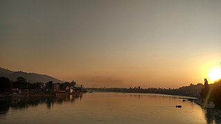
Rishikesh, also spelt as Hrishikesh, is a city near Dehradun in the Indian state Uttarakhand. The northern part of Rishikesh is in the Dehradun district while the southern part is in the Pauri Garhwal district. It is situated on the right bank of the Ganges River and is a pilgrimage town for Hindus, with ancient sages and saints meditating there in search of higher knowledge. There are numerous temples and ashrams built along the banks of the river.

The Asan Barrage is a barrage in the Uttarakhand-Himachal Pradesh border region in Doon Valley,, northern India, situated at the confluence of the Eastern Yamuna Canal and the Asan River and about 11 km (7 mi) from Dakpathar, and 28 km. northwest of Dehradun in Uttarakhand. The barrage is 287.5m long and has water throughout the year which is fed from the river Asan and the discharge channel of the river Yamuna. Since 2020 it has been declared as Uttarakhand's first Ramsar site.

Bhowali is a town and a municipal board in Nainital District in the state of Uttarakhand, India. It is situated at a distance of 11 km (6.8 mi) from the city of Nainital, the district headquarters; at an average elevation of 1,654 m (5,427 ft) from sea level. It is the seat of Bhowali tehsil, one of the eight subdivisions of Nainital district.

Gauchar is a Hill Town sort of a valley town located in Karnaprayag tehsil within Chamoli district of Uttarakhand state in India. Gauchar is situated on the left bank of river Alaknanda and is en route to the celebrated holy destination of Badrinath. It is well known for being one of the cleanest place in country. It has previously topped Swachta sarvekshan best ganga town award. Situated at an altitude of 800 metres (2,620 ft) above the sea level, Gauchar is surrounded by seven mountains. Gauchar is well known for its historic trade fair and airstrip. Gauchar town known for its great work to curb loss of lives in 2013 flood disaster of Uttarakhand. This town is unique in terms of its geographical location and topography. Gauchar is located on one of the largest pieces of flatland in this mountainous region of Uttarakhand. Education institution in Gauchar includes a beautiful Kendriya Vidyalaya adjacent to the main playground.

Tanakpur is a city and a municipal board in Champawat district of Uttarakhand state of India. Located in the plains area in the northern part of India. The town is the gateway for Purnagiri Temple as well as the 'Gateway to the Kumaon Himalayas'.

Ramnagar is a town and municipal board in the Nainital district of Kumaon, India. It is located approximately 65 kilometres (40 mi) from Nainital, the headquarters of the district.
Jaunsar-Bawar is a hilly region in Garhwal division of Uttarakhand, northern India. It is located in the north-west of Dehradun district, along the border with the state of Himachal Pradesh.

Patal Bhuvaneshwar is a limestone Hindu cave temple 14 km from Gangolihat in the Pithoragarh district of Uttarakhand state in India. It is located in the village of Bhubneshwar. Legend and folklore have it that this cave enshrines Lord Shiva and thirty three koti demigods [33 Types, In hindu neumerology "Koti" means "Types"]. The cave is 160 m long and 90 feet deep from the point of entrance. Limestone rock formations have created various spectacular stalactite and stalagmite figures of various hues and forms. This cave has a narrow tunnel-like opening which leads to a number of caves. The cave is fully electrically illuminated. Built by the flow of water, Patal Bhuvaneshwar is not just one cave, rather a series of caves within caves.

Dehradun is the temporary capital of The Indian state of Uttarakhand, and has a rich and eventful history, it also finds mention in scriptures as well.

Italic text'Bold text
Uttarakhand is a state in the northern part of India. It is often referred to as the "Devbhumi" due to its religious significance and numerous Hindu temples and pilgrimage sites found throughout the state. As a result, religious tourism forms a major portion of the tourism in the state. Uttarakhand is known for the natural environment of the Himalayas. 2019 Tourist Arrivals Domestic – 40,000,000 per/year and Foreigner – 150,000 per year. Tourism business in Uttarakhand generated ₹ 23,000 crores during 2013–14.

Dehradun Terminal railway station is a railway station in Dehradun, Uttarakhand, India, on the Northern line of the Northern Railway network. It is owned by Indian Railways.

Sahasradhara, -- popularly but incorrectly spelled Sahastradhara -- meaning thousandfold spring, is one of the most popular tourist destinations located in Dehradun district in Uttarakhand state of India. It lies on 30.387231 latitude and 78.131606 longitude. Earlier, in the 19th century it was also known as Sansadhara, or the petrifying forest. This place is situated on the banks of the small river, Baldi River which a tributary of Song River. The place has once had magnificent beauty of nature where water drips from the limestone stalactites, making the water abundant in sulpur and thus the place is known for its sulphur springs. It is sulphur water spring of relatively lower temperature than its surroundings. It is a warehouse of excellent beauty of caves, waterfalls and terrace farming on steppe by the local people. Its magnificent nature attracts people from faraway places. This place is at about 11 km from the city of Dehradun.

Tapkeshwar Temple, also known as Tapkeshwar Mahadev Temple, is a temple in Dehradun dedicated to Shiva. The temple is on the bank of the Tons River, built on top of a natural cave, which holds the temple's main shivalinga.


