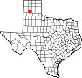
Rockwell Place, Texas

Last updated

Rockwell Place, Texas
USA Texas location map.svg
Red pog.svg
Rockwell Place
Usa edcp location map.svg
Red pog.svg
Rockwell Place
Coordinates: 35°02′32″N101°54′30″W / 35.04222°N 101.90833°W / 35.04222; -101.90833
CountryUnited States
State Texas
County Randall
Area
[1]
  Total2.33 sq mi (6.03 km2)
  Land2.33 sq mi (6.03 km2)
  Water0.0 sq mi (0.0 km2)
Elevation
[2]
3,639 ft (1,109 m)
Time zone UTC-6 (Central (CST))
  Summer (DST) UTC-5 (CDT)
ZIP Codes
79015 (Canyon)
79118 (Amarillo)
Area code 806
FIPS code 48-62834
GNIS feature ID2805836 [2]

Rockwell Place is an unincorporated area and census-designated place (CDP) in Randall County, Texas, United States. It was first listed as a CDP prior to the 2020 census. [2]

Contents

It is north of the center of the county, on the east side of Interstate 27. It is bordered to the south by Canyon, the county seat. Amarillo is 14 miles (23 km) to the north.

Demographics

Historical population
CensusPop.Note
2020 1,811
U.S. Decennial Census [3]
1850–1900 [4] 1910 [5]
1920 [6] 1930 [7] 1940 [8]
1950 [9] 1960 [10] 1970 [11]
1980 [12] 1990 [13] 2000 [14]
2010 [15] 2020 [16]

Rockwell Place first appeared as a census designated place in the 2020 U.S. Census. [17] [15] [16]

2020 census

Rockwell Place CDP, Texas – Racial and ethnic composition
Note: the US Census treats Hispanic/Latino as an ethnic category. This table excludes Latinos from the racial categories and assigns them to a separate category. Hispanics/Latinos may be of any race.
Race / Ethnicity (NH = Non-Hispanic)Pop 2020 [16] % 2020
White alone (NH)1,31772.72%
Black or African American alone (NH)60.33%
Native American or Alaska Native alone (NH)80.44%
Asian alone (NH)20.11%
Pacific Islander alone (NH)10.06%
Other race alone (NH)50.28%
Mixed race or Multiracial (NH)995.47%
Hispanic or Latino (any race)37320.60%
Total1,811100.00%

Related Research Articles

Garciasville is a census-designated place (CDP) in Starr County, Texas, United States. It is a new CDP for the 2010 census, with a population of 46.

Bluetown is a census-designated place (CDP) in Cameron County, in the U.S. state of Texas. The population was 356 at the 2010 census. It is part of the Brownsville–Harlingen Metropolitan Statistical Area.

Arroyo Gardens is a census-designated place (CDP) in Cameron County, in the U.S. state of Texas. The population was 456 at the 2010 census. Prior to the 2010 census, the community was part of the Arroyo Gardens-La Tina Ranch CDP. It is part of the Brownsville–Harlingen Metropolitan Statistical Area.

La Tina Ranch is a census-designated place (CDP) in Cameron County, in the U.S. state of Texas. The population was 618 at the 2010 census. Prior to the 2010 census, the community was part of the Arroyo Gardens-La Tina Ranch CDP. It is part of the Brownsville–Harlingen Metropolitan Statistical Area.

Chula Vista is a census-designated place (CDP) in Cameron County, in the U.S. state of Texas. Prior to the 2010 census, the community was part of the Chula Vista-Orason CDP. It is part of the Brownsville–Harlingen Metropolitan Statistical Area.

Orason is a census-designated place (CDP) in Cameron County, in the U.S. state of Texas. The population was 129 at the 2010 census. Prior to the 2010 census, the community was part of the Chula Vista-Orason CDP. It is part of the Brownsville–Harlingen Metropolitan Statistical Area.

Las Palmas II is a census-designated place (CDP) in Cameron County, in the U.S. state of Texas. The population was 1,605 at the 2010 census. Prior to the 2010 census, the community was part of the Las Palmas-Juarez CDP. It is part of the Brownsville–Harlingen Metropolitan Statistical Area.

Juarez is a census-designated place (CDP) in Cameron County, in the U.S. state of Texas. The population was 1,017 at the 2010 census. Prior to the 2010 census, the community was part of the Las Palmas-Juarez CDP. It is part of the Brownsville–Harlingen Metropolitan Statistical Area.

Las Palmas is a census-designated place (CDP) in Zapata County in the U.S. state of Texas. It was a new CDP from the 2010 census, with a population of 67. It is part of the Zapata Micropolitan Statistical Area.

Country Acres is a former census-designated place (CDP) in San Patricio County, Texas, United States. The population was 185 at the 2010 census. Prior to the 2010 census, Country Acres was part of the Falman-County Acres CDP. In 2022, it was annexed by the city of Aransas Pass.

Loma Vista is a census-designated place (CDP) in Starr County, Texas, United States. It is a new CDP, formed from part of the North Escobares CDP prior to the 2010 census, with a population of 160.

Moraida is a census-designated place (CDP) in Starr County, Texas, United States. It is a new CDP, formed from part of the North Escobares CDP prior to the 2010 census, with a population of 212.

Pena is an unincorporated community and census-designated place (CDP) in Starr County, Texas, United States. It was formed from part of the North Escobares CDP prior to the 2010 census, with a population of 118.

Salineño North is a census-designated place (CDP) in Starr County, Texas, United States. This was a new CDP for the 2010 census, with a population of 115.

Los Arrieros is an unincorporated community and census-designated place in Starr County, Texas, United States. Its population was 91 as of the 2010 census. U.S. Route 83 passes through the community.

Rice Tracts is an unincorporated community and census-designated place (CDP) in Cameron County, Texas, United States. It was first listed as a CDP prior to the 2020 census.

Salida del Sol Estates is a colonia and census-designated place (CDP) in Hidalgo County, Texas, United States. It was first listed as a CDP in the 2020 census.

Normandy is an unincorporated community and census-designated place (CDP) in Maverick County, Texas, United States. It was first listed as a CDP prior to the 2020 census.

Praesel is an unincorporated community and census-designated place (CDP) in Milam County, Texas, United States. It was first listed as a CDP in the 2020 census with a population of 446.

Carter is an unincorporated area and census-designated place (CDP) in Parker County, Texas, United States. It was first listed as a CDP prior to the 2020 census.

References

  1. "2020 U.S. Gazetteer Files – Texas". United States Census Bureau. Retrieved September 30, 2021.
  2. 1 2 3 U.S. Geological Survey Geographic Names Information System: Rockwell Place, Texas
  3. "Decennial Census by Decade". United States Census Bureau .
  4. "1900 Census of Population - Population of Texas By Counties And Minor Civil Divisions" (PDF). United States Census Bureau .
  5. "1910 Census of Population - Supplement for Texas" (PDF). United States Census Bureau .
  6. "1920 Census of Population - Number of Inhabitants - Texas" (PDF). United States Census Bureau .
  7. "1930 Census of Population - Number of Inhabitants - Texas" (PDF). United States Census Bureau .
  8. "1940 Census of Population - Number of Inhabitants - Texas" (PDF). United States Census Bureau .
  9. "1950 Census of Population - Number of Inhabitants - Texas" (PDF). United States Census Bureau .
  10. "1960 Census of Population - Number of Inhabitants - Texas" (PDF). United States Census Bureau .
  11. "1970 Census of Population - Number of Inhabitants - Texas" (PDF). United States Census Bureau .
  12. "1980 Census of Population - Number of Inhabitants - Texas" (PDF). United States Census Bureau .
  13. "1990 Census of Population - Population and Housing Unit Counts - Texas" (PDF). United States Census Bureau .
  14. "2000 Census of Population - Population and Housing Unit Counts - Texas" (PDF). United States Census Bureau .
  15. 1 2 "2010 Census of Population - Population and Housing Unit Counts - Texas" (PDF). United States Census Bureau .
  16. 1 2 3 "P2: Hispanic or Latino, and Not Hispanic or Latino by Race – 2020: DEC Redistricting Data (PL 94-171) – Rockwell Place CDP, Texas". United States Census Bureau.
  17. "2020 Geography Changes". United States Census Bureau.