Rockwell Place, Texas | |
|---|---|
 Rockwell Place  Rockwell Place | |
| Coordinates: 35°02′32″N101°54′30″W / 35.04222°N 101.90833°W | |
| Country | United States |
| State | Texas |
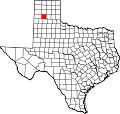
| County | Randall |
| Area | |
• Total | 2.33 sq mi (6.03 km2) |
| • Land | 2.33 sq mi (6.03 km2) |
| • Water | 0 sq mi (0.0 km2) |
| Elevation | 3,639 ft (1,109 m) |
| Time zone | UTC-6 (Central (CST)) |
| • Summer (DST) | UTC-5 (CDT) |
| ZIP Codes | |
| Area code | 806 |
| FIPS code | 48-62834 |
| GNIS feature ID | 2805836 [2] |
Rockwell Place is an unincorporated area and census-designated place (CDP) in Randall County, Texas, United States. It was first listed as a CDP prior to the 2020 census. [2]
Contents
It is north of the center of the county, on the east side of Interstate 27. It is bordered to the south by Canyon, the county seat. Amarillo is 14 miles (23 km) to the north.