Lake Tanglewood, Texas

Last updated

Lake Tanglewood, Texas
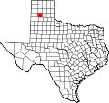
TXMap-doton-LakeTanglewood.PNG
Location of Lake Tanglewood, Texas
Randall County LakeTanglewood.svg
Coordinates: 35°03′25″N101°46′54″W / 35.05694°N 101.78167°W / 35.05694; -101.78167
CountryUnited States
State Texas
County Randall
Area
[1]
  Total1.50 sq mi (3.89 km2)
  Land1.12 sq mi (2.91 km2)
  Water0.38 sq mi (0.98 km2)
Elevation
[2]
3,386 ft (1,032 m)
Population
 (2010)
  Total796
  Estimate 
(2019) [3]
886
  Density788.26/sq mi (304.38/km2)
Time zone UTC-6 (Central (CST))
  Summer (DST) UTC-5 (CDT)
FIPS code 48-40804 [4]
GNIS feature ID2413565 [2]

Lake Tanglewood is a village in Randall County, Texas, United States. The population was 796 at the 2010 census. It is part of the Amarillo, Texas Metropolitan Statistical Area.

Contents

Geography

According to the United States Census Bureau, the village has a total area of 1.5 square miles (3.9 km2), of which 1.1 square miles (2.8 km2) is land and 0.4 square miles (1.0 km2) (27.40%) is water.

Demographics

Historical population
CensusPop.Note
1980 485
1990 63731.3%
2000 82529.5%
2010 796−3.5%
2019 (est.)886 [3] 11.3%
U.S. Decennial Census [5]

2020 census

Lake Tanglewood racial composition [6]
(NH = Non-Hispanic) [lower-alpha 1]
RaceNumberPercentage
White (NH)61689.8%
Black or African American (NH)10.15%
Native American or Alaska Native (NH)30.44%
Asian (NH)50.73%
Pacific Islander (NH)10.15%
Some Other Race (NH)40.58%
Mixed/Multi-Racial (NH)131.9%
Hispanic or Latino 436.27%
Total686

As of the 2020 United States census, there were 686 people, 318 households, and 243 families residing in the village.

2000 census

As of the census [4] of 2000, there were 825 people, 342 households, and 282 families residing in the village. The population density was 777.4 inhabitants per square mile (300.2/km2). There were 402 housing units at an average density of 378.8 per square mile (146.3/km2). The racial makeup of the village was 98.06% White, 0.73% Native American, 0.12% Pacific Islander, 0.36% from other races, and 0.73% from two or more races. Hispanic or Latino of any race were 1.94% of the population.

There were 342 households, out of which 24.6% had children under the age of 18 living with them, 78.7% were married couples living together, 2.3% had a female householder with no husband present, and 17.5% were non-families. 14.0% of all households were made up of individuals, and 6.1% had someone living alone who was 65 years of age or older. The average household size was 2.41 and the average family size was 2.66.

In the village, the age distribution of the population shows 17.8% under the age of 18, 5.5% from 18 to 24, 19.4% from 25 to 44, 39.9% from 45 to 64, and 17.5% who were 65 years of age or older. The median age was 49 years. For every 100 females there were 102.7 males. For every 100 females age 18 and over, there were 99.4 males.

The median income for a household in the village was $67,344, and the median income for a family was $76,641. Males had a median income of $61,944 versus $30,938 for females. The per capita income for the village was $38,159. About 5.5% of families and 6.2% of the population were below the poverty line, including 9.7% of those under age 18 and 4.8% of those age 65 or over.

Related Research Articles

<span class="mw-page-title-main">East Dundee, Illinois</span> Village in Illinois, United States

East Dundee is a village in Kane County with a small section in Cook County. The population was 3,152 at the 2020 census.

<span class="mw-page-title-main">Forest View, Illinois</span> Village in Illinois, United States

Forest View is a village in Cook County, Illinois, United States. Per the 2020 census, the population was 792. It is primarily an industrial corridor adjacent to the Chicago neighborhood of Garfield Ridge, which is on the village's southern border.

<span class="mw-page-title-main">Indian Head Park, Illinois</span> Village in Illinois, United States

Indian Head Park is a village in Cook County, Illinois, United States, slightly north of the intersection of Interstate 294 and Interstate 55. The village is south of Western Springs, west of Countryside, north and east of Burr Ridge. Per the 2020 census, the population was 4,065. The village's ZIP code is 60525.

<span class="mw-page-title-main">Justice, Illinois</span> Village in Illinois, United States

Justice is a village in Cook County, Illinois, United States, established in 1911. Per the 2020 census, the population was 12,600.

<span class="mw-page-title-main">Merrionette Park, Illinois</span> Village in Illinois, United States

Merrionette Park is a village in Cook County, Illinois, United States. The population was 1,969 as of the 2020 census.

<span class="mw-page-title-main">Orland Hills, Illinois</span> Village in Illinois, United States

Orland Hills is a village in Cook County, Illinois, United States. Per the 2020 census, the population was 6,893.

<span class="mw-page-title-main">South Barrington, Illinois</span> Village in Illinois, United States

South Barrington is a residential suburb in Cook County, Illinois, United States, south of Barrington. Per the 2020 census, the population was 5,077. South Barrington is a wealthy suburb of Chicago. It is the location of the famous megachurch Willow Creek Community Church, Goebbert's Pumpkin Patch and Farm, and a lifestyle center named The Arboretum of South Barrington.

<span class="mw-page-title-main">South Chicago Heights, Illinois</span> Village in Illinois, United States

South Chicago Heights is a village and a south suburb in Cook County, Illinois, United States. The population was 4,026 at the 2020 census.

<span class="mw-page-title-main">Stickney, Illinois</span> Village in Illinois, United States

Stickney is a village in Cook County, Illinois, United States. The village is named for Alpheus Beede Stickney, a railroad executive who played a central role in establishing the Clearing Industrial District. Per the 2020 census, the population was 7,110. It was well known in the 1920s and early 1930s as the home for several bordellos linked to mobster Al Capone's empire.

<span class="mw-page-title-main">South Elgin, Illinois</span> Village in Illinois, United States

South Elgin is a village in Kane County, Illinois, United States. Per the 2020 census, the population was 23,865. In 2007, Money magazine named South Elgin as 82nd of 100 entries in its "America's Best Places to Live" edition and again in 2011 as 98th of 100 entries.

<span class="mw-page-title-main">Clemmons, North Carolina</span> Village in North Carolina

Clemmons is a village in Forsyth County, North Carolina, United States and a suburb of Winston-Salem. The population was 21,177 at the 2020 census, with an estimated population of 21,517 in 2021.

<span class="mw-page-title-main">Lakehills, Texas</span> CDP in Texas, United States

Lakehills is a census-designated place (CDP) in Bandera County, Texas, United States. The population was 5,150 at the 2010 census, making it the most populous place in Bandera county. It is part of the San Antonio Metropolitan Statistical Area.

<span class="mw-page-title-main">Live Oak, Texas</span> City in Texas, United States

Live Oak is a city in Bexar County, Texas, United States. The population was 15,781 at the 2020 census. It is part of the San Antonio Metropolitan Statistical Area.

<span class="mw-page-title-main">Meridian, Texas</span> City in Texas, United States

Meridian is a city and the county seat of Bosque County in central Texas, United States. It is forty-seven miles northwest of Waco. The population was 1,493 at the 2010 census.

<span class="mw-page-title-main">Sunrise Beach Village, Texas</span> City in Texas, United States

Sunrise Beach Village is a city in Llano County, Texas, United States. The village was established in 1973. The population was 713 at the 2010 census.

<span class="mw-page-title-main">Buffalo Springs, Texas</span> Village in Texas, United States

Buffalo Springs is a village in Lubbock County, Texas, United States. The population was 453 at the 2010 census. It is part of the Lubbock Metropolitan Statistical Area.

<span class="mw-page-title-main">LaCoste, Texas</span> City in Texas, United States

La Coste is a city in Medina County, Texas, United States. The population was 1,119 at the 2010 census. It is part of the San Antonio Metropolitan Statistical Area.

<span class="mw-page-title-main">Palisades, Texas</span> Village in Texas, United States

Palisades is a village in Randall County, Texas, United States. The population was 325 at the 2010 census. It is part of the Amarillo, Texas Metropolitan Statistical Area.

<span class="mw-page-title-main">Timbercreek Canyon, Texas</span> Village in Texas, United States

Timbercreek Canyon is a village in Randall County, Texas, United States. As of the 2010 census, the village population was 418. It is part of the Amarillo, Texas Metropolitan Statistical Area.

<span class="mw-page-title-main">San Diego, Texas</span> City in Texas, United States

San Diego is a city in Duval and Jim Wells counties, Texas, United States. The population was 3,748 at the 2020 census and 4,488 at the 2010 census. It is located primarily in Duval County, of which it is the county seat.

References

  1. "2019 U.S. Gazetteer Files". United States Census Bureau. Retrieved August 7, 2020.
  2. 1 2 U.S. Geological Survey Geographic Names Information System: Lake Tanglewood, Texas
  3. 1 2 "Population and Housing Unit Estimates". United States Census Bureau. May 24, 2020. Retrieved May 27, 2020.
  4. 1 2 "U.S. Census website". United States Census Bureau . Retrieved January 31, 2008.
  5. "Census of Population and Housing". Census.gov. Retrieved June 4, 2015.
  6. "Explore Census Data". data.census.gov. Retrieved May 20, 2022.
  7. https://www.census.gov/ [ not specific enough to verify ]
  8. "About the Hispanic Population and its Origin". www.census.gov. Retrieved May 18, 2022.
  1. Note: the US Census treats Hispanic/Latino as an ethnic category. This table excludes Latinos from the racial categories and assigns them to a separate category. Hispanics/Latinos can be of any race. [7] [8]