Rodborough

Last updated

Rodborough
Gloucestershire UK location map.svg
Red pog.svg
Rodborough
Location within Gloucestershire
Population5,174 (2021 Census) [1]
OS grid reference SO851051
Civil parish
  • Rodborough
District
Shire county
Region
Country England
Sovereign state United Kingdom
Post town STROUD
Postcode district GL5
Dialling code 01453
Police Gloucestershire
Fire Gloucestershire
Ambulance South Western
UK Parliament
List of places
UK
England
Gloucestershire
51°44′38″N2°12′54″W / 51.744°N 2.215°W / 51.744; -2.215

Rodborough is a large village and civil parish in the district of Stroud, Gloucestershire, in South West England. It is directly south of the town of Stroud, north of the town of Nailsworth and north-west of the town of Minchinhampton. The parish includes the settlements of Bagpath (not to be confused with Bagpath in the Ozleworth valley), Butterrow, Kingscourt, Lightpill and Rooksmoor, and is adjacent to the Stroud suburb of Dudbridge. The population taken at the 2011 census was 5,334. [2]

Contents

Geography

An entrance to Rodborough Fort Rodborough fort.jpg
An entrance to Rodborough Fort

Built on a hill, Rodborough village is near Rodborough Common, a public recreation area popular with walkers. Most of the common land was donated to the National Trust in 1937 by Thomas Bainbrigge Fletcher (1878–1950), a naval officer and entomologist. [3] On the common is Rodborough Fort, a folly built in 1761 that is now a private house. [4]

Amenities

Rodborough Common is a Site of Special Scientific Interest. [5]

The parish has two primary schools, [6] several public houses, a large hotel called The Bear of Rodborough Hotel [7] and a community hall. [8] It is home to the historic Winstones Ice Cream Factory. [9] It has a large and active Christian community who attend the Church of England parish church of St. Mary Magdalene or Rodborough Tabernacle United Reformed Church, and its various clubs and societies include a football club, a Scout group and a mother and toddler network.

The local newspaper is the Stroud News & Journal and the parish council also produces a quarterly newsletter called The Commoner. [10]

Governance

Rodborough is served by Rodborough Parish Council, Stroud District Council and Gloucestershire County Council. Until 1974 much of the parish was part of the Stroud Urban District Council and today it forms part of the Stroud urban area, along with Stroud and Cainscross.

An electoral ward in the same name exists. All of this ward is within the civil parish and a reduced population therefore applies: at the 2011 Census it was 4,543. [11]

Notable people

[Captain John Perry RN (1670-1732) was born in Rodborough. A pioneer of applying science to engineering, he worked for Tsar Peter the Great and later the Adventurers in Deeping Fen near Spalding, where his remains are interred.][Sir John Dean Paul, 1st Baronet]] (1775–1852), of Rodborough, was a landowner, banker, and painter. [12]

The Gothic Revival architect Benjamin Bucknall was born in Rodborough in 1833. He designed the uncompleted Woodchester Mansion and a number of houses and Roman Catholic churches and convents, particularly in Gloucestershire and South Wales. In later life he worked in Algiers. [13] The Reverend Wilbert Awdry, who wrote The Railway Series of children's books that inspired the TV series Thomas & Friends , moved to 30 Rodborough Avenue in 1965 and lived there until his death on 21 March 1997. [14]

Related Research Articles

<span class="mw-page-title-main">Gloucestershire</span> County of England

Gloucestershire is a ceremonial county in South West England. It borders Herefordshire to the north-west, Worcestershire to the north, Warwickshire to the north-east, Oxfordshire to the east, Wiltshire to the south, Bristol and Somerset to the south-west, and the Welsh county of Monmouthshire to the west. The city of Gloucester is the largest settlement and the county town.

<span class="mw-page-title-main">Dursley</span> Market town in Gloucestershire, England

Dursley is a market town and civil parish in the Stroud District of Gloucestershire, England. It lies between the cities of Bristol and Gloucester. It is under the northeast flank of Stinchcombe Hill, and about 4 miles (6.4 km) southeast of the River Severn. The town is adjacent to the village of Cam. The population of Dursley was 7,463 at the 2021 Census.

<span class="mw-page-title-main">Stroud</span> Town in Gloucestershire, England

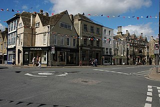
Stroud is a market town and civil parish in Gloucestershire, England. It is the main town in Stroud District. The town's population was 13,500 in 2021.

<span class="mw-page-title-main">Painswick</span> Human settlement in England

Painswick is a town and civil parish in the Stroud District in Gloucestershire, England. Originally the town grew from the wool trade, but it is now best known for its parish church's yew trees and the local Rococo Garden. The village is mainly constructed of locally quarried Cotswold stone. Many of the buildings feature south-facing attic rooms once used as weavers' workshops.

<span class="mw-page-title-main">Stroud District</span> Non-metropolitan district in England

<span class="mw-page-title-main">Nailsworth</span> Town in Gloucestershire, England

Nailsworth is a town and civil parish in the Stroud District in Gloucestershire, England, lying in one of the Stroud Valleys in the Cotswolds, on the A46 road, 4 miles (6.4 km) south of Stroud and about 25 miles (40 km) north-east of Bristol and Bath. The parish had a population of 5,794 at the 2011 census.

<span class="mw-page-title-main">Tetbury</span> Town in Gloucestershire, England

Tetbury is a town and civil parish inside the Cotswold district in Gloucestershire, England. It lies on the site of an ancient hill fort, on which an Anglo-Saxon monastery was founded, probably by Ine of Wessex, in 681. The population of the parish was 5,250 in the 2001 census, increasing to 5,472 at the 2011 census. The population further increased to 6,453 in the 2021 Census.

<span class="mw-page-title-main">Minchinhampton</span> Town in Gloucestershire, England

Minchinhampton is a Cotswolds market town and a civil parish in the Stroud District of Gloucestershire, South West England. The town is located on a hilltop, 4 miles (6.4 km) south-east of Stroud. The common offers wide views over the Severn Estuary into Wales and further into the Cotswolds. It is an ancient town which was recorded in the Domesday Book.

<span class="mw-page-title-main">Woodchester</span> Human settlement in England

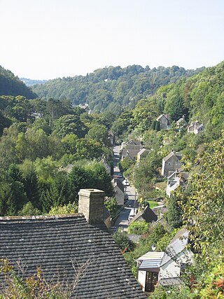
Woodchester is a Gloucestershire village in the Nailsworth Valley, a valley in the South Cotswolds in England, running southwards from Stroud along the A46 road to Nailsworth. The parish population taken at the 2011 census was 1,206.

<span class="mw-page-title-main">Chalford</span> Human settlement in England

Chalford is a large village in the Frome Valley of the Cotswolds in Gloucestershire, England. It is to the southeast of Stroud about four miles upstream. It gives its name to Chalford parish, which covers the villages of Chalford, Chalford Hill, France Lynch, Bussage and Brownshill, spread over two square miles of the Cotswold countryside. At this point the valley is also called the Golden Valley.

<span class="mw-page-title-main">Stroud (UK Parliament constituency)</span> Parliamentary constituency in the United Kingdom, 1955 onwards

Stroud is a constituency represented in the House of Commons of the UK Parliament. It is held by Siobhan Baillie of the Conservative Party. Formerly a safe Conservative seat, Stroud has been a marginal seat since 1992, changing hands four times in seven elections since then.

<span class="mw-page-title-main">Coaley</span> Human settlement in England

Coaley is a village in the English county of Gloucestershire roughly 4 miles from the town of Dursley, and 5 miles from the town of Stroud. The village drops from the edge of the Cotswold Hills, overlooked by Frocester Hill and Coaley Peak picnic site, towards the River Cam at Cam and Cambridge and the Severn Estuary beyond. It has a population of around 770.

<span class="mw-page-title-main">Owlpen</span> Human settlement in England

Owlpen is a small village and civil parish in the Stroud district of Gloucestershire, England, set in a valley in the Cotswold hills. It is about one mile (1.6 km) east of Uley, and three miles (4.8 km) east of Dursley. The Owlpen valley is set around the settlement like an amphitheatre of wooded hills open to the west. The landscape falls within the Cotswold Area of Outstanding Natural Beauty, so designated in 1966. The population of the parish in mid-2010 was 29 (est.), the smallest in Gloucestershire.

<span class="mw-page-title-main">Selsley</span> Human settlement in England

Selsley is a village within the civil parish of King's Stanley and district of Stroud, in Gloucestershire, England. It is composed of around 175 houses, scattered around the western and eastern edge of a Cotswold spur, located approximately 2 miles (3.2 km) south of Stroud.

<span class="mw-page-title-main">Nympsfield</span> Human settlement in England

Nympsfield is a village and civil parish in the English county of Gloucestershire. It is located around four miles south-west of the town of Stroud. As well as Nympsfield village, the parish contains the hamlet of Cockadilly. The population taken at the 2011 census was 382.

<span class="mw-page-title-main">Bagpath</span> Human settlement in England

Bagpath is a hamlet in Gloucestershire, England, in the Ozleworth valley south of the village of Kingscote and forming part of Kingscote civil parish. The hamlet consists of two separate settlements of Bagpath and Newington Bagpath, although residents of Newington Bagpath refer to their settlement solely as Newington.

<span class="mw-page-title-main">Benjamin Bucknall</span> English architect

Benjamin Bucknall was an English architect of the Gothic Revival in South West England and South Wales, and then of neo-Moorish architecture in Algeria. His most noted works include the uncompleted Woodchester Mansion in Gloucestershire, England and his restoration of the Villa Montfeld in El Biar, Algiers.

<span class="mw-page-title-main">Rodborough Common, Gloucestershire</span> Biological and geological Site of Special Scientific Interest in Gloucestershire, United Kingdom

Rodborough Common is a 116.0-hectare (287-acre) biological and geological Site of Special Scientific Interest in Gloucestershire, notified in 1954. The site is listed in the ‘Stroud District’ Local Plan, adopted November 2005, Appendix 6 as an SSSI and a Regionally Important Geological Site (RIGS). The Common is also a Special Area of Conservation (SAC) under the EU Habitats Directive

References

  1. "Stroud". City population. Retrieved 25 October 2022.
  2. "Parish population 2011". Archived from the original on 4 March 2016. Retrieved 30 March 2015.
  3. "Rodborough Common". Stroud History. 2009. Archived from the original on 28 August 2020. Retrieved 30 December 2007.
  4. "History of Rodborough Fort". Rodborough Fort. Retrieved 28 August 2020.
  5. Natural England SSSI information on the citation, map and units of assessment
  6. "Rodborough Community Primary School". Rodborough Community Primary School. Archived from the original on 6 August 2019. Retrieved 28 August 2020.
  7. "The Bear of Rodborough". Cotswold Inns. Archived from the original on 5 July 2020. Retrieved 28 August 2020.
  8. "Community Hall and Pitch – Bookings". Rodborough Parish Council. Archived from the original on 28 August 2020. Retrieved 28 August 2020.
  9. "Winstones Cotswold Ice Cream". Winstones Cotswold Ice Cream. Archived from the original on 9 January 2019. Retrieved 28 August 2020.
  10. "The Commoner". Rodborough Parish Council. Archived from the original on 28 August 2020. Retrieved 28 August 2020.
  11. "Ward population 2011". Archived from the original on 2 April 2015. Retrieved 30 March 2015.
  12. Paul, John Dean (1775-1852), First Baronet of Rodborough (M), University of Victoria, accessed 25 July 2021
  13. "The architects". Woodchester Mansion. Archived from the original on 28 August 2020. Retrieved 28 August 2020.
  14. "Rev. Awdry". Rodborough Parish Church. Archived from the original on 17 December 2018. Retrieved 1 January 2019.