Related Research Articles

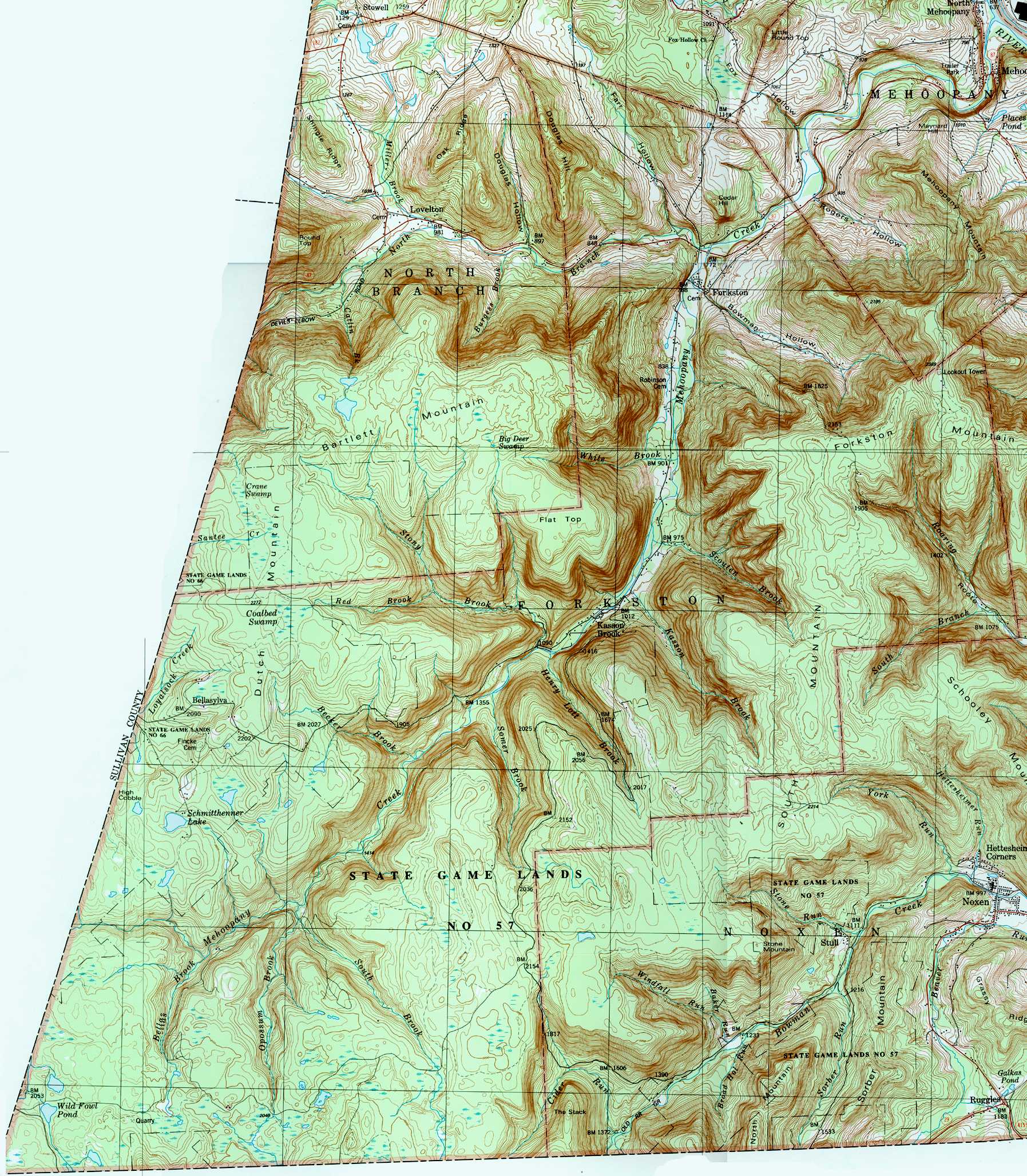
Mehoopany Creek is a tributary of the Susquehanna River in Sullivan and Wyoming counties, Pennsylvania, in the United States. It is approximately 26.8 miles (43.1 km) long. In Sullivan County the creek flows through Colley Township and in Wyoming County it flows through Forkston Township and Mehoopany Township. The stream's watershed has an area of 123 square miles (320 km2). Its major tributaries include Stony Brook and North Fork Mehoopany Creek.

Sugar Hollow Creek is a tributary of Bowman Creek in Wyoming County, Pennsylvania, in the United States. It is approximately 4.7 miles (7.6 km) long and flows through Mehoopany Township and Eaton Township. The watershed of the creek has an area of 7.07 square miles (18.3 km2). The creek is not designated as an impaired waterbody. The surficial geology near its mouth consists of alluvium, Wisconsinan Outwash, and Wisconsinan Till. The creek is a High-Quality Coldwater Fishery, a Migratory Fishery, and Class A Wild Trout Waters.

Roaring Run is a tributary of Bowman Creek in Wyoming County, Pennsylvania, in the United States. It is approximately 4.9 miles (7.9 km) long and flows through Forkston Township, Noxen Township, and Monroe Township. It has two named tributaries: Newton Run and South Branch Roaring Run. The watershed of Roaring Run has an area of 11.4 square miles (30 km2). It is designated as a High-Quality Coldwater Fishery and a Migratory Fishery and the stream is Class A Wild Trout Waters. The surficial geology in its vicinity consists of alluvium, alluvial terrace, alluvial fan, bedrock, Wisconsinan Till, and Wisconsinan Ice-Contact Stratified Drift. A bridge carrying Pennsylvania Route 29 crosses the stream.
South Branch Roaring Run is a tributary of Roaring Run in Wyoming County, Pennsylvania, in the United States. It is approximately 2.0 miles (3.2 km) long and flows through Noxen Township and Forkston Township. The watershed of the stream has an area of 3.31 square miles (8.6 km2). The surficial geology in its vicinity consists of bedrock, Wisconsinan Till, Wisconsinan Bouldery Till, Wisconsinan Ice-Contact Stratified Drift, and alluvium. South Branch Roaring Run is classified as Class A Wild Trout Waters.
Sugar Run is a tributary of Bowman Creek in Luzerne County and Wyoming County, in Pennsylvania, in the United States. It is approximately 1.8 miles (2.9 km) long and flows through Lake Township in Luzerne County and Noxen Township in Wyoming County. The watershed of the stream has an area of 1.02 square miles (2.6 km2). The surficial geology in its vicinity consists of alluvium, alluvial fan, Wisconsinan Till, and bedrock. The stream's watershed is designated as a High-Quality Coldwater Fishery and a Migratory Fishery.
Fox Hollow is a tributary of Mehoopany Creek in Wyoming County, Pennsylvania, in the United States. It is approximately 0.8 miles (1.3 km) long and flows through Mehoopany Township. The watershed of the stream has an area of 1.83 square miles (4.7 km2). The Fox Hollow Swamp is listed on A Natural Areas Inventory of Wyoming County.
North Branch Mehoopany Creek is a tributary of Mehoopany Creek in Bradford County, Sullivan County, and Wyoming County, in Pennsylvania, in the United States. It is approximately 14 miles (23 km) long and flows through Wilmot Township in Bradford County, Colley Township in Sullivan County, and North Branch Township and Forkston Township. The watershed of the creek has an area of 40.0 square miles (104 km2). The creek has eight named direct tributaries, including hollows. In the 1940s and 1950s, the average discharge for September was found to be just 6.8 cubic feet per second (0.19 m3/s), but was found to be over 100 cubic feet per second (2.8 m3/s) for July and August.
Bowman Hollow is a tributary of Mehoopany Creek in Wyoming County, Pennsylvania, in the United States. It is approximately 2.2 miles (3.5 km) long and flows through Forkston Township. The watershed of the stream has an area of 3.08 square miles (8.0 km2). The stream flows over a highly secluded waterfall known as the Bowman Hollow Falls.

White Brook is a tributary of Mehoopany Creek in Wyoming County, Pennsylvania, in the United States. It is approximately 1.8 miles (2.9 km) long and flows through North Branch Township and Forkston Township, in Wyoming County, Pennsylvania, in the United States. The stream's watershed has an area of 1.75 square miles (4.5 km2). The stream is classified as a High-Quality Coldwater Fishery. It has a small waterfall and a hiking path is located nearby.
Scouten Brook is a tributary of Mehoopany Creek in Wyoming County, Pennsylvania, in the United States. It is approximately 2.2 miles (3.5 km) long and flows through Forkston Township. The watershed of the stream has an area of 2.66 square miles (6.9 km2). The stream is designated as a High-Quality Coldwater Fishery and has wild trout. It is one of five large brooks to cut through South Mountain.
Kasson Brook is a tributary of Mehoopany Creek in Wyoming County, Pennsylvania, in the United States. It is approximately 2.7 miles (4.3 km) long and flows through Forkston Township. The watershed of the stream has an area of 4.53 square miles (11.7 km2). The stream is not designated as an impaired waterbody and is classified as a High-Quality Coldwater Fishery. It is one of several streams to cut through South Mountain.
Henry Lott Brook is a tributary of Mehoopany Creek in Wyoming County, Pennsylvania, in the United States. It is approximately 2.4 miles (3.9 km) long and flows through Forkston Township. The watershed of the stream has an area of 2.68 square miles (6.9 km2). The stream is not designated as an impaired waterbody and it is classified as a High-Quality Coldwater Fishery. It is one of five large tributaries of Mehoopany Creek to cut through the Mehoopany Creek-Bowman Creek watershed divide.
Somer Brook is a tributary of Mehoopany Creek in Wyoming County, Pennsylvania, in the United States. It is approximately 3.7 miles (6.0 km) long and flows through Noxen Township and Forkston Township. The watershed of the stream has an area of 4.48 square miles (11.6 km2). The stream is not designated as an impaired waterbody and is classified as a High-Quality Coldwater Fishery. Fauna that have been observed in the stream's vicinity include northern water shrews and trout.
Becker Brook is a tributary of Mehoopany Creek in Wyoming County, Pennsylvania, in the United States. It is approximately 2.6 miles (4.2 km) long and flows through Forkston Township. The watershed of the stream has an area of 2.33 square miles (6.0 km2). The stream is designated as a High-Quality Coldwater Fishery. It is small and secluded, with a swamp known as the Becker Brook Swamp at its headwaters.
South Brook is a tributary of Mehoopany Creek in Luzerne County and Wyoming County, in Pennsylvania, in the United States. It is approximately 6.0 miles (9.7 km) long and flows through Ross Township and Lake Township, Luzerne County, Pennsylvania in Luzerne County and Forkston Township in Wyoming County. The watershed of the stream has an area of 10.1 square miles (26 km2). Wild trout are present in the stream and it has one named tributary, which is known as Opossum Brook.
Opossum Brook is a tributary of South Brook in Luzerne County and Wyoming County, in Pennsylvania, in the United States. It is approximately 4.0 miles (6.4 km) long and flows through Ross Township in Luzerne County and Forkston Township in Wyoming County. The watershed of the stream has an area of 5.13 square miles (13.3 km2). The stream is classified as a High-Quality Coldwater Fishery and has wild trout. The stream has a number of wetlands in its watershed and in some areas is good for birdwatching.
Bellas Brook is a tributary of Mehoopany Creek in Wyoming County, Pennsylvania, in the United States. It is approximately 2.3 miles (3.7 km) long and flows through Forkston Township. The watershed of the stream has an area of 2.71 square miles (7.0 km2). The stream is not designated as an impaired waterbody and is classified as a High-Quality Coldwater Fishery.
Farr Hollow is a tributary of North Branch Mehoopany Creek in Wyoming County, Pennsylvania, in the United States. It is approximately 3.1 miles (5.0 km) long and flows through Windham Township and North Branch Township. The watershed of the stream has an area of 2.99 square miles (7.7 km2). The stream is not designated as an impaired waterbody and flows through a mixture of forested and agricultural land. Eleven different fish species have been observed in the stream, including brook trout.
Douglas Hollow is a tributary of North Branch Mehoopany Creek in Wyoming County, Pennsylvania, in the United States. It is approximately 1.7 miles (2.7 km) long and flows through North Branch Township. The watershed of the stream has an area of 1.57 square miles (4.1 km2). The stream is classified as a Coldwater Fishery and is inhabited by four fish species, including wild brook trout. Its entire length is within 300 meters (980 ft) of a road and it flows through a mixture of forested and agricultural land.
Burgess Brook is a tributary of North Branch Mehoopany Creek in Wyoming County, Pennsylvania, in the United States. It is approximately 1.2 miles (1.9 km) long and flows through North Branch Township. The watershed of the stream has an area of 1.42 square miles (3.7 km2). The stream is narrow, with a high gradient, and is located in a remote area, mostly far away from any roads. It is designated as Class A Wild Trout Waters and has a large population of brook trout, as well as smaller numbers of brown trout. Three other fish species are also present in the stream.
References
- 1 2 3 4 United States Geological Survey, The National Map Viewer , retrieved August 12, 2016
- 1 2 3 Pennsylvania Gazetteer of Streams (PDF), November 2, 2001, pp. 2, 21, retrieved August 18, 2016
- 1 2 3 4 Geographic Names Information System, Feature Detail Report for: Rogers Hollow , retrieved August 18, 2016
- ↑ United States Geological Survey (1987), forkston.jpg , retrieved August 25, 2016
- ↑ Pennsylvania Environmental Council, Wyoming County Office of Community Planning, Mehoopany Creek Watershed Association (March 31, 2007), MEHOOPANY CREEK and LITTLE MEHOOPANY CREEK WATERSHEDS RIVERS CONSERVATION PLAN (PDF), p. 17, retrieved August 18, 2016CS1 maint: multiple names: authors list (link)
- ↑ "FEDERAL WATER POLLUTION CONTROL ACT SECTION 401", Pennsylvania Bulletin , retrieved August 18, 2016
- ↑ "PFBC announces trout stocking schedules", Wyoming County Press Examiner , March 23, 2016, retrieved August 18, 2016
- ↑ "PFBC announces 2015 trout stocking schedule", Wyoming County Press Examiner , April 1, 2015, retrieved August 18, 2016