Demenika is a village/suburb in the municipality of Patras, Achaea, Greece. It lies 5 kilometres (3.1 mi) south of the city centre, south of the river Glafkos. It is part of the community of Saravali within the municipal unit of Messatida. It is 2 km northeast of Ovrya and 4 km east of Paralia. The population was 2,783 in 2011. The Greek National Road 33 passes through the village, and the new Greek National Road 9 passes south of the village.
Mintilogli or Midilogli is a village and a community in the municipal unit of Paralia in the municipality of Patras in Achaea, Greece. It is 1 km south of Paralia, and 8 km southwest of Patras city centre. Ovrya is to the east. The community consists of the villages Mintilogli (seat) and Chantziliako. Its population is around 2,000. The Greek National Road 9 passes the village on the north and west.
Sageika is a village and a community in the municipal unit of Movri, western Achaea, Greece. The population of the village is about 1000. It is located in the plains between the Movri hills and the Gulf of Patras. It is 3 km west of Kareika, 6 km east of Metochi, 9 km southwest of Kato Achaia and 28 km southwest of Patras. The Greek National Road 9 runs through the village.
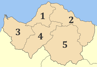
Dymi is a former municipality in Achaea, West Greece, Greece. Since the 2011 local government reform it is part of the municipality West Achaea, of which it is a municipal unit. The municipal unit has an area of 71.553 km2. Its seat of administration was the town of Kato Achaia. It is located 20 km southwest of Patras.
Alissos is a village and a community in the municipal unit of Dymi, Achaea, Greece. It is located near the Gulf of Patras, 3 km east of Kato Achaia, 3 km southwest of Kaminia and 17 km southwest of Patras. The community consists of the villages Alissos, Kamenitsa, Paralia Alissou and Profitis Elissaios. The Greek National Road 9 and the railway from Patras to Pyrgos run between Alissos and Paralia Alissou.
Niforeika is a village and a community in the municipality of West Achaea in northwestern Achaea, Greece. It is located near the Gulf of Patras, 4 km east of Limnochori, 3 km west of Kato Achaia and 22 km southwest of Patras. The distance from the Greek National Road 9 is about 4 km. The community consists of the villages Niforeika and Paralia Niforeikon.
Limnochori is a village and a community in the municipal unit of Movri in Achaea, Greece. The community consists of the villages Limnochori, Kalamaki, Kato Limnochori and Paralia Kalamakiou. It is located in the plains near the Gulf of Patras. It is 4 km north of Sageika, 4 km southeast of Lakkopetra, 6 km west of Kato Achaia and 4 km east of Araxos Airport.
Metochi is a village and a community in the municipal unit of Larissos, western Achaea, Greece. The community consists of the villages Metochi, Vouprasio, Neo Vouprasio and Lappas. Lappas was the seat of the former municipality of Larissos. Metochi is located in the plains near the Ionian Sea coast, 5 km south of Araxos, 3 km southwest of Araxos Airport, 14 km west of Kato Achaia and 32 km west of Patras. The Prokopos lagoon, which is fed by the river Larissos, is 1 km north of Metochi. Lappas is on the Greek National Road 9 and on the railway from Patras to Pyrgos.
Kaminia is a village in Achaea, Greece. It is part of the municipal unit of Vrachnaiika. Kaminia is situated on the Ionian Sea coast, 15 km southwest of Patras, and 6 km east of Kato Achaia. Since the 1980s, the village is bypassed by Greek National Road 9. Kaminia had a small train station on the currently unexploited Patras–Pyrgos railway.
Tsoukalaiika is a village and a community in the municipal unit of Vrachnaiika in the northern part of Achaea, Greece. It is on the southwestern edge of the metropolitan area of Patras, on the Gulf of Patras, 13 km southwest of Patras city centre. It is located on the Greek National Road 9 and the railway from Patras to Pyrgos.
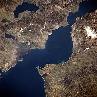
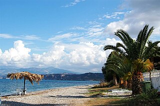
The Gulf of Patras is a branch of the Ionian Sea in Western Greece. On the east, it is closed by the Strait of Rion between capes Rio and Antirrio, near the Rio-Antirrio bridge, that is the entrance of the Gulf of Corinth. On the west, it is bounded by a line from Oxeia island to Cape Araxos. To the north it is bounded by the shore of Aetolia-Acarnania in continental Greece, and to the south by Achaea in the Peloponnese peninsula. It is 40–50 km long, 10–20 km wide, and has an area of 350–400 km2.

Akrata, is a town and a former municipality in Achaea, West Greece, Greece. Since the 2011 local government reform it is part of the municipality Aigialeia, of which it is a municipal unit. The municipal unit has an area of 180.169 km2. Akrata is located on the right bank of the river Krathis, 3 km from its outflow into the Gulf of Corinth. The Greek National Road 8A/E65 and the railway from Patras to Corinth pass through the municipal unit, northeast of the town. The nearest town is Aigeira, 4 km to the east. It is 23 km southeast of Aigio, 52 km east of Patras and 23 km northeast of Kalavryta.
Kareika is a village and a community in the municipal unit of Movri, Achaea, Greece. The community consists of the villages Kareika, Gomosto, Karamesineika and Rachi. It is located north of the Movri hills, 3 km east of Sageika, 6 km southwest of Kato Achaia and 25 km southwest of Patras. The Greek National Road 9/E55 passes through the community.

Kato Achaia is a town and a community in Achaea, West Greece, Greece. Since the 2011 local government reform it is part of the municipality West Achaea, of which it is the seat of administration. The community Kato Achaia consists of the town Kato Achaia and the villages Alykes, Manetaiikia, Paralia Kato Achaias and Piso Sykea. Nearby are the ruins of the ancient city of Dyme.

Diakopto is a town and a former municipality in Achaea, West Greece, Greece. Since the 2011 local government reforms it is a municipal unit of the Aigialeia municipality. The municipal unit has an area of 103.932 km2. Population 6,429 (2011). The town of Diakopto is situated on the Gulf of Corinth, near the mouth of the Vouraikos river and at the lower end of the Vouraikos Gorge. The 750 mm gauge Diakofto–Kalavryta Railway built in 1885 leads up to the town of Kalavryta passing the Mega Spilaio Monastery at about halfway. Diakopto is on the old Greek National Road 8 ; the new Greek National Road 8A passes 1 km to the south. Diakopto is located about 40 km east of Patras, and 15km southeast of Aigio.
Platanos is a village and a community in the municipal unit of Akrata, Achaea, Greece. In 2011 Platanos had a population of 231 for the village, and 259 for the community, which includes the mountain villages Ano Potamia, Korinthiako Balkoni and Tsivlos. The village Platanos consists of two parts: the seaside settlement Paralia Platanou on the Gulf of Corinth and Platanos proper at about 250 m elevation on a mountain slope directly above Paralia Platanou. The villages Ano Potamia and Tsivlos are about 10 km south of Platanos. Platanos is 5 km west of Akrata and 18 km southeast of Aigio. The Greek National Road 8A and the railway Corinth - Patras pass north of Platanos.
Trapeza is a village and a community in the municipal unit of Diakopto, Achaea, Greece. It is located 4 km southeast of Diakopto and 8 km west of Akrata. In 2001 Trapeza had a population of 274 for the village and 314 for the community, which includes the village Paralia Trapezis. Between 1892 and 1940, its name was Nea Voura.

Patras Province was a province covering the western part of the Achaea prefecture, Greece. Its largest city and seat of administration was Patras. Its territory corresponded with that of the current municipalities Patras, Erymanthos and West Achaea, and the municipal unit Erineos. It was abolished in 2006.
Psofida is a village and a community in the municipal unit of Aroania in the southern part of Achaea, Greece. The community consists of the villages Psofida, Ano Psofida, Tripotama, Ano Tripotama, Kato Tripotama and Vasiliki. Psofida was named after the ancient Arcadian town Psophis, that was located near the present village Tripotama. It is situated near the confluence of the rivers Erymanthos, Aroanios and Seiraios, and near the tripoint of Achaea, Arcadia and Elis. It is 4 km southwest of Livartzi, 9 km east of Lampeia, 25 km southwest of Kalavryta and 45 km southeast of Patras. The Greek National Road 33 passes through Tripotama.