Amaliada is a town and a former municipality in northwestern Elis, West Greece, Greece. Since the 2011 local government reform it is part of the municipality Ilida, of which it is the seat and a municipal unit. The municipal unit has an area of 251.945 km2. In 2011, the municipal unit had 28,520 inhabitants, of whom 16,763 lived in the town of Amaliada. It is near the archaeological site of Elis, the city-state whose territory was the site of the ancient Olympic Games. It is situated in the plains of Elis, 6 km from the Ionian Sea. It is 10 km southeast of Gastouni, 16 km northwest of Pyrgos and 60 km southwest of Patras.

Greek National Road 33 is a single carriageway road in southern Greece. It connects Patras with the Greek National Road 74 near Levidi, passing through the western and southern foothills of Mount Erymanthos.

Patras is Greece's third-largest city and the regional capital of Western Greece, in the northern Peloponnese, 215 km (134 mi) west of Athens. The city is built at the foothills of Mount Panachaikon, overlooking the Gulf of Patras.
Rio is a town in the suburbs of Patras and a former municipality in Achaea, West Greece, Greece. Since the 2011 local government reform it is part of the municipality Patras, of which it is a municipal unit. The municipal unit has an area of 98.983 km2. The municipal unit had a population of 14,622 in 2011. The campus of the University of Patras and the Casino Rio is located in Rio.
Demenika is a village/suburb in the municipality of Patras, Achaea, Greece. It lies 5 kilometres (3.1 mi) south of the city centre, south of the river Glafkos. It is part of the community of Saravali within the municipal unit of Messatida. It is 2 km northeast of Ovrya and 4 km east of Paralia. The population was 2,783 in 2011. The Greek National Road 33 passes through the village, and the new Greek National Road 9 passes south of the village.
Mintilogli or Midilogli is a village and a community in the municipal unit of Paralia in the municipality of Patras in Achaea, Greece. It is 1 km south of Paralia, and 8 km southwest of Patras city centre. Ovrya is to the east. The community consists of the villages Mintilogli (seat) and Chantziliako. Its population is around 2,000. The Greek National Road 9 passes the village on the north and west.

Vrachnaiika is a town and a former municipality in Achaea, West Greece, Greece. Since the 2011 local government reform it is part of the municipality Patras, of which it is a municipal unit. The municipal unit has an area of 32.111 km2. It is suburb of a Patras, about 11 km southwest of the city centre, on the Gulf of Patras coast. The population of the town is around 2,700 and of the municipal unit around 4,600. The community has a disused rail station on the line from Patras to Pyrgos. The Greek National Road 9 passes south of the centre.
Saravali is a village and a community in the municipal unit of Messatida, Achaea, Greece. The community is located at the southeastern edge of the agglomeration of Patras. The community consists of the villages Saravali, Agios Stefanos, Demenika, Kefalovryso and Bakari. Saravali is 6 km south of Patras city centre. Adjacent communities are Petroto to the east, Patras to the north, Ovrya to the west and Krini to the south. The Greek National Road 9 runs through the community.
Gastouni is a town and a former municipality in Elis, West Greece, Greece. Since the 2011 local government reform it is part of the municipality Pineios, of which it is the seat and a municipal unit. The municipal unit has an area of 59.325 km2. Gastouni is situated in a flat rural area, 5 km from the Ionian Sea. The river Pineios flows into the sea near Gastouni. The town is 6 km (4 mi) south of Andravida, 4 km (2 mi) east of Vartholomio, 11 km (7 mi) northwest of Amaliada and 26 km (16 mi) northwest of Pyrgos. The population of the town proper was 7,485 in 2011. The Greek National Road 9/E55 and the railway from Patras to Pyrgos pass east of Gastouni. There is a 12th-century Byzantine church in the southwestern quarter Katholiki.
Kallithea is a community in the suburbs of Patras in Achaea, Greece. It is located 9 km south of downtown Patras, on the Greek National Road 33 to Tripoli. The community consists of the villages Kallithea and Ano Kallithea, and is part of the municipal unit Messatida within the municipality of Patras. The nearest villages are Ovrya to the north and Thea to the west. To the east lies the mountain Omplos.
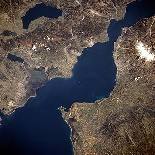
The Gulf of Patras is a branch of the Ionian Sea in Western Greece. On the east, it is closed by the Strait of Rion between capes Rio and Antirrio, near the Rio-Antirrio bridge, that is the entrance of the Gulf of Corinth. On the west, it is bounded by a line from Oxeia island to Cape Araxos. To the north it is bounded by the shore of Aetolia-Acarnania in continental Greece, and to the south by Achaea in the Peloponnese peninsula. It is 40–50 km long, 10–20 km wide, and has an area of 350–400 km2.

Diakopto is a town and a former municipality in Achaea, West Greece, Greece. Since the 2011 local government reforms it is a municipal unit of the Aigialeia municipality. The municipal unit has an area of 103.932 km2. Population 6,429 (2011). The town of Diakopto is situated on the Gulf of Corinth, near the mouth of the Vouraikos river and at the lower end of the Vouraikos Gorge. The 750 mm gauge Diakofto–Kalavryta Railway built in 1885 leads up to the town of Kalavryta passing the Mega Spilaio Monastery at about halfway. Diakopto is on the old Greek National Road 8 ; the new Greek National Road 8A passes 1 km to the south. Diakopto is located about 40 km east of Patras, and 15km southeast of Aigio.
Metamorfosi Sotiros is a neighbourhood in the southern part of the city of Patras. The area is next to the municipality of Messatida, the subdivision is divided between the two municipalities and then, the communes of Ovrya and Saravali in which are now municipal districts. The subdivision was built in 1970 and many inhabitants came from Tritaia. It also features the central vegetable shop in Patras. The area is the northern part of Demenika. Farmlands covers the outer areas as well as a small forest.
Proastio is a neighbourhood in the northern part of the city of Patras, 6 km from the city centre. The Greek National Road 8 and the OSE Corinth - Patras railway line pass through the neighbourhood. The river Charadros flows 1 km north. The municipal boundary with Rio is also to the north.
Lefka is a neighbourhood in the southern part of the city of Patras, 5 km directly and 6 km south via road from the downtown core. It was originally called "Botovayia".
Eglykada is a neighbourhood in the eastern part of the city of Patras, 7 km by road from the city center. Eglykada is accessed with the Patras-Ekilistra Road which is 2 km long in the neighbourhood. Since 2002, it is linked with the Patras Bypass in which it was first constructed in the late-1990s and the interchange later on. Its interchange is circular with only one access from the entrance lane but it does not have any tolls and the intersection is by the entrance and the merging lanes. It is 200 m south of the road and 500 m from its nearest tunnel.
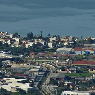
Paralia is a town and a former municipality in Achaea, West Greece, Greece.
Panagitsa is a small stream in the south of the Patras Area in northcentral Achaea, Greece. The source of the Panagitsa is on the western slope of the mountain Omplos, near Omplos Monastery. It flows northwest along the villages Krini and Ovrya. It flows into the Gulf of Patras in Paralia.