Achaea or Achaia, sometimes transliterated from Greek as Akhaia, is one of the regional units of Greece. It is part of the region of West Greece and is situated in the northwestern part of the Peloponnese peninsula. The capital is Patras. Its population surpassed 300,000 for the first time in 2001.
Messinia is a regional unit in the southwestern part of the Peloponnese region, in Greece. Until the implementation of the Kallikratis plan on 1 January 2011, Messinia was a prefecture (nomos) covering the same territory. The capital and largest city of Messinia is Kalamata.

Lechaina is a town and a former municipality in Elis, West Greece, Greece. Since the 2011 local government reform it is part of the municipality Andravida-Kyllini, of which it is the seat and a municipal unit. The municipal unit has an area of 94.567 km2. It is situated 39 km north of the city of Pyrgos, and 60 km southwest of Patras. In 2011, its population was 4,855.

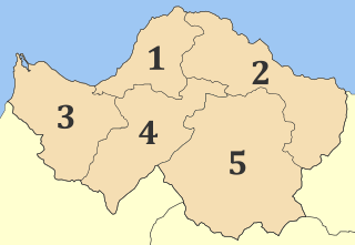
Elis or Ilia is one of the regional units of Greece. It is part of the region of Western Greece. It is situated in the western part of the Peloponnese peninsula. Its capital is Pyrgos.

Greek National Road 8a was a toll road in the Attica, Peloponnese and West Greece regions. It connected Athens with the cities of Corinth and Patras. It was built in the 1960s as a replacement for the old National Road 8 as the major route to the Peloponnese, and bypasses most towns. The National Road 8a has gradually been upgraded to a motorway, the A8. Since April 2017, the complete length of the A8 motorway has been operational.

Western Greece Region is one of the thirteen regions of Greece. It comprises the western part of continental Greece and the northwestern part of the Peloponnese peninsula.
Tripoli is a city in the central part of the Peloponnese, in Greece. It is the capital of the Peloponnese region as well as of the regional unit of Arcadia. The homonym municipality has around 47,000 inhabitants.

Pyrgos is the capital of the Elis regional unit in Greece. The city is located in the western part of the Peloponnese, in the middle of a plain, 4 kilometres from the Ionian Sea. The river Alfeios flows into sea about 7 km (4 mi) south of Pyrgos. The population of the town Pyrgos is 25,180, and of the municipality 47,995 (2011). Pyrgos is 16 km (10 mi) west of Olympia, 16 km (10 mi) southeast of Amaliada, 70 km (43 mi) southwest of Patras and 85 km (53 mi) west of Tripoli.

Gargalianoi is a town and a former municipality in Messenia, Peloponnese, Greece. Since the 2011 local government reform it is part of the municipality Trifylia, of which it is a municipal unit. The municipal unit has an area of 122.680 km2. It is situated 4 km from the Ionian Sea coast, 18 km north of Pylos, 21 km south of Kyparissia and 43 km west of Kalamata. The Greek National Road 9 passes through the town.

Greek National Road 8 is a single carriageway with at-grade intersections in the Attica, Peloponnese and West Greece regions. It connects Athens with the cities of Corinth and Patras. Since the 1960s it has been replaced for most of its length with the National Road 8A, a limited-access toll road that bypasses most towns, as the major route to the Peloponnese. The National Road 8A has been upgraded to a motorway, the Olympia Odos (A8).
Antirrio is a town and a former municipality in Aetolia-Acarnania, West Greece, Greece. Since the 2011 local government reform it is part of the municipality Nafpaktia, of which it is a municipal unit. The municipal unit has an area of 50.794 km2.
Metochi is a village and a community in the municipal unit of Larissos, western Achaea, Greece. The community consists of the villages Metochi, Vouprasio, Neo Vouprasio and Lappas. Lappas was the seat of the former municipality of Larissos. Metochi is located in the plains near the Ionian Sea coast, 5 km south of Araxos, 3 km southwest of Araxos Airport, 14 km west of Kato Achaia and 32 km west of Patras. The Prokopos lagoon, which is fed by the river Larissos, is 1 km north of Metochi. Lappas is on the Greek National Road 9 and on the railway from Patras to Pyrgos.
Volakas is a former municipality in Elis, West Greece, Greece. Since the 2011 local government reform it is part of the municipality Pyrgos, of which it is a municipal unit. The municipal unit has an area of 70.790 km2. Its seat of administration was in the town of Epitalio.

Kato Achaia is a town and a community in Achaea, West Greece, Greece. Since the 2011 local government reform it is part of the municipality West Achaea, of which it is the seat of administration. The community Kato Achaia consists of the town Kato Achaia and the villages Alykes, Manetaiikia, Paralia Kato Achaias and Piso Sykea. Nearby are the ruins of the ancient city of Dyme.

Ernst Moritz Theodor Ziller was a Saxon architect who later became a Greek national. In the late 19th and early 20th centuries, he was a major designer of royal and municipal buildings in Athens, Patras, and other Greek cities.

Methoni is a village and a former municipality in Messenia, Peloponnese, Greece. Since the 2011 local government reform it is part of the municipality of Pylos-Nestoras, of which it is a municipal unit. The municipal unit has an area of 97.202 km2. Its name may be derived from Mothona, a mythical rock. It is located 11 km south of Pylos and 11 km west of Foinikounta. The municipal unit of Methoni includes the nearby villages of Grizokampos, Finikouda, Foiniki, Lachanada, Varakes, Kainourgio Chorio, Kamaria, Evangelismos and the Oinnoussai Islands. The islands are Sapientza, Schiza and Santa Marina; they form a natural protection for Methoni harbour. The town is also known by the Italian name Modone, which it was called by the Venetians.

The Greek Motorway 5 is a motorway in Greece.
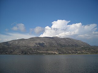
Lapithas is a mountain located in southern Elis in the western Peloponnese in Greece. The mountain is named after the mythical people, the Lapiths. In the west the mountain touches the Ionian Sea. It is 15 to 20 km long and 10 km wide and covers and area of 100 to 150 km². A large part of the mountain is covered with pine forests, but has suffered great damage in the forest fires of August 2007.
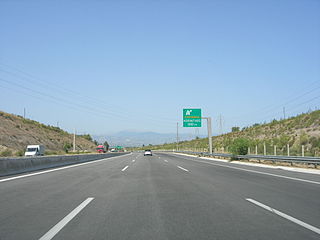
Olympia Odos is a toll motorway system on the Peloponnese in Greece. Starting from Eleusis in the Athens metropolitan area, the Olympia Odos motorways follow the Gulf of Corinth to the Rio–Antirrio bridge and the city of Patras, and along the Ionian Sea coastline, down to southwestern Peloponnese.