
Phocis is one of the regional units of Greece. It is part of the administrative region of Central Greece. It stretches from the western mountainsides of Parnassus on the east to the mountain range of Vardousia on the west, upon the Gulf of Corinth. It is named after the ancient region of Phocis, but the modern regional unit also includes parts of ancient Locris and Doris.

Greek National Road 33 is a single carriageway road in southern Greece. It connects Patras with the Greek National Road 74 near Levidi, passing through the western and southern foothills of Mount Erymanthos.

Greek National Road 3 is a single carriageway road in Greece. It connects Eleusis near Athens with the border of North Macedonia at Niki. It passes through Larissa and Florina. At Niki, it connects with the M5K motorway to Bitola. Greek National Road 3 is one of the longest highways in Greece and until the 1960s it served as the main route from Larissa to Thessaloniki. The new A1 motorway now offers a faster connection to Thessaloniki. Most of the EO3, except the southernmost section between Eleusis and Bralos, is part of the E65.

Greek National Road 5 is a single carriageway road in western Greece. It connects Antirrio, at the north end of the Rio-Antirrio bridge, with Ioannina in northwestern Greece, passing through Agrinio and Arta. The southern part, between Amfilochia and Antirrio, is part of the European route E55. The northern part, between Ioannina and Amfilochia, forms the European route E951. It passes on the east side of the Ambracian Gulf. In the future much of the traffic that used this road will be diverted to the new A5 motorway, which has already taken over parts of the road.

Greek National Road 48 is a single carriageway road in central Greece. It connects the Greek National Road 5 at Antirrio with the town Livadeia, passing through Naupactus and Delphi. The section between Antirrio and Itea is part of European route E65. The GR-48 passes through the regional units Aetolia-Acarnania, Phocis and Boeotia.

Greek National Road 38 is a single carriageway road in western and central Greece. It connects Thermo with Lamia, via Agrinio and Karpenisi. It passes through the regional units Aetolia-Acarnania, Evrytania and Phthiotis. The section between Agrinio and Lamia coincides with the European route E952.

Greek National Road 44 is a single carriageway road in central Greece. It connects Thebes with Karystos on southern Euboea, via Chalcis and Eretria. The total length of the GR-44 is nearly 160 km. The highway lies in the regional units of Boeotia and Euboea.

Arachova is a mountain town and a former municipality in the western part of Boeotia, Greece. Since the 2011 local government reform it is a municipal unit, part of the municipality Distomo-Arachova-Antikyra. Its name is of South Slavic origin and denotes a place with walnut trees. It is a tourist destination due to its location in the mountains, its traditions and its proximity to the town of Delphi.

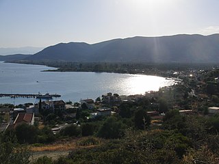
Itea, is a town and a former municipality in the southeastern part of Phocis, Greece. Since 2011 local government reforms made the city a part of the municipality Delphi, of which it is a municipal unit.

Greek National Road 82 is a single carriageway road in southern Greece. It connects Pylos with Sparti via Kalamata. It passes through the regional units Messenia and Laconia, on the Peloponnese peninsula. Its length is 110 km.

Amfissa is a town in Phocis, Greece, part of the municipality of Delphi, of which it is the seat and a municipal unit. The municipal unit has an area of 315.174 km2. It lies on the northern edge of the olive forest of the Crissaean plain, between two mountains, Giona to the west and Parnassus to the east, 200 km (120 mi) northwest of Athens and 20 km (12 mi) of Delphi, as well as 85 km (53 mi) northeast of Naupactus and 72 km (45 mi) south of Lamia.

European route E 65 is a north-south Class-A European route that begins in Malmö, Sweden and ends in Chania, Greece. The road is about 4,400 km (2,700 mi) in length.
Kastraki is a village in Phocis, Greece, part of the municipal unit Efpalio. It is near the left bank of the river Mornos and 3 km from the Gulf of Corinth. It is 3 km (2 mi) west of the village Efpalio and 6 km (4 mi) northeast of the town of Nafpaktos.
The Greek National Road 42 is a highway in northwestern Aetolia-Acarnania and in Lefkada, Greece. It links the town of Lefkada with the Greek National Road 5 in Amfilochia, passing through the town of Vonitsa.
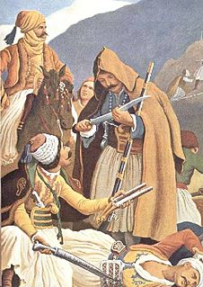
The Battle of Arachova was fought between an Ottoman Empire force under the command of Mustafa Bey and Greek irregulars under Georgios Karaiskakis. On 18 November, Mustafa Bey's 2,000 Ottoman Turkish troops were blockaded in the village of Arachova. An 800-man Turkish force that attempted to relieve the defenders three days later failed. On 22 November Mustafa Bey was mortally wounded and tensions quickly rose between the new commander Kehagias and his Albanian officers as morale plunged. At midday on 24 November the Ottomans made a disastrous attempt at breaking out. Most were killed in the fighting or perished from hypothermia.

Kastellia is a village in the municipal unit of Gravia, Phocis, Greece. It is situated at the western end of the wide Cephissus valley, at the foot of the mountains Giona and Oeta. It is 3 km northwest of Gravia, 19 km north of Amfissa and 23 km south of Lamia. The Greek National Road 27 passes southeast of the village. The railway from Athens to Thessaloniki passes east of the village, with the nearest railway station at Bralos, 4 km east.
Erateini is a village in the southern part of Phocis, Greece. It was the municipal seat of the municipality of Tolofon. Erateini is situated on the Gulf of Corinth, 14 km west of Galaxidi, 19 km south of Lidoriki, 23 km southwest of Amfissa and 35 km east of Nafpaktos. The Greek National Road 48 passes through the village. In 2011, Erateini had a population of 856.
Kallithea is a village and a community in the municipal unit of Tolofon, southern Phocis, Greece. The community consists of the villages Kallithea, Agia Eirini, Agios Nikolaos, Agios Spyridonas, Klovinos, Flampourakia and the uninhabited islands Agios Nikolaos and Prasoudi. Kallithea is situated in the mountains near the coast of the Gulf of Corinth. The two largest villages, Agios Nikolaos and Agios Spyridonas, are on the coast. Kallithea is 5 km northwest of Tolofon, 26 km southwest of Amfissa and 27 km east of Nafpaktos. The Greek National Road 48 passes along the coast. There is a ferry service from Agios Nikolaos to Aigio, Peloponnese.
A.C. Fokikos is a Greek professional football club of Phocis, Greece, established in Amfissa. The club was first founded in 1932 under the name "Panamfissaikos" and twenty years later (1952) was renamed to "Amfissaikos". In 1964 was finally named "Fokikos" and currently plays in Football League, the second level of the Greek football league system. Team's colors are blue and white. Badge of the team consists of two olive tree branches, framing a ball.
The modern town of Delphi is situated immediately west of the archaeological site of the same name, and hence is a popular tourist destination. Delphi is also the name of the modern-day municipality in which the town of Delphi is situated.


