
Thessaloniki, also familiarly known as Thessalonica, Salonica or Salonika, is the second-largest city in Greece, with over 1 million inhabitants in its metropolitan area, and the capital of Greek Macedonia, the administrative region of Central Macedonia and the Decentralized Administration of Macedonia and Thrace. Its nickname is η Συμπρωτεύουσα (Symprotévousa), literally "the co-capital", a reference to its historical status as the Συμβασιλεύουσα (Symvasilévousa) or "co-reigning" city of the Eastern Roman (Byzantine) Empire, alongside Constantinople.

Kaftanzoglio Stadium is a sports stadium in Thessaloniki, Greece. The stadium was built with money donated by the Kaftanzoglou Foundation, hence its name. At the time of its opening on 27 October 1960, the stadium was one of the highest quality stadiums in the Balkans. It currently has 27,770 seats, owing to a comprehensive renovation before reopening to host football matches for the 2004 Summer Olympics, which was centred in Athens. It was the largest stadium in Greece until 1982, but has since been surpassed in capacity by the Olympic Stadium in Athens.

Greek National Road 3 is a single carriageway road in Greece. It connects Eleusis near Athens with the border of North Macedonia at Niki. It passes through Larissa and Florina. At Niki, it connects with the M5K motorway to Bitola. Greek National Road 3 is one of the longest highways in Greece and until the 1960s it served as the main route from Larissa to Thessaloniki. The new A1 motorway now offers a faster connection to Thessaloniki. Most of the EO3, except the southernmost section between Eleusis and Bralos, is part of the E65.
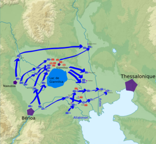
The Battle of Yenidje or Yenice or Battle of Giannitsa, was a battle between the Greek Army and the Ottoman Army on October 19–20 1912, during the First Balkan War. The Greek Army defeated the Ottomans, opening the way towards Thessaloniki and capturing Yenidje.

Greek National Road 2 is a single carriageway with at-grade intersections, located in the regions of West Macedonia, Central Macedonia and East Macedonia and Thrace. It connects the Albanian border near Florina with the Turkish border near Alexandroupoli. Its section east of Thessaloniki has been replaced by the new A2 motorway. The section between the Albanian border and Thessaloniki is part of European route E86.
Greek National Road 67 is a limited access road in northern Greece. It connects the Motorway 25 with the Thessaloniki International Airport.

Akanthos was an ancient Greek city on the Athos peninsula, on the narrow neck of land between the sacred mountain and the mainland, to the northwest of the Xerxes Canal. It was founded in the 7th century BCE as a colony of Andros, itself a colony of Chalcis in Euboea. Chalcidice was multi-cultural. The archaeology of the region suggests that some Hellenes were already there. The site is on the north-east side of Akti, on the most eastern peninsula of Chalcidice.
Ierissos is a small town on the east coast of the Akti peninsula in Chalkidiki, Greece. It is located 160 km from Thessaloniki, and 10 km from the border of the Autonomous Monastic State of the Holy Mountain, or Mount Athos. It is the site of Ancient city and former bishopric Hierissus, and as such remains a Latin Catholic titular see. Ferries run from Ierissos to the east coast of Mount Athos.
Livadi is a village in Vasilika, Thessaloniki, Greece.

Nea Roda is a village 115 km (71 mi) southeast of Thessaloniki, on the narrowest point of the Athos peninsula in the municipality of Stagira-Akanthos, Chalkidiki, Greece.

Greek National Road 51 is a single carriageway road in northeastern Greece. It connects the Greek National Road 2 near Feres with the Bulgarian border near Ormenio. The main towns on the GR-51 are Didymoteicho and Orestiada. The entire GR-51 is part of the European route E85. Its length is about 128 km. It runs from south to north, parallel to the river Evros.
Ardameri is a village in the regional unit of Thessaloniki of Greece, at the foot of Mount Chortiatis, on the site of the medieval settlement of Ardamerion (Αρδαμέριον).

Greek National Road 65 is a national highway of Greece. It connects the Greek National Road 2 at Diavata, a northwestern suburb of Thessaloniki, with Kilkis. Most of the National-Road has been upgraded to a Motor-Road, connecting Thessaloniki via Kilkis with Doirani, the eastern border of Greece and North Macedonia.
Langadikia is a village located in the regional unit of Thessaloniki, in Greece, north-east of Mount Chortiatis. It has facilities such as "Lagkadikia High School " and "Agronomy Department" that are used by many conterminous villages, as it is located on a cross-road between the lakes Koroneia and Volvi.
The village has about 800 permanent inhabitants. It is part of the municipal unit of Koroneia, which contains also the villages Agios Vasileios, Gerakarou, Vasiloudi, and Ardameri.
Lagkadas Province was one of the two provinces of Thessaloniki Prefecture of Greece. Its territory corresponded with that of the current municipalities Lagkadas and Volvi. It was abolished in 2006.
Thessaloniki Province was one of the two provinces of Thessaloniki Prefecture of Greece. Its territory corresponded with that of the current municipalities Ampelokipoi-Menemeni, Chalkidona, Delta, Kalamaria, Kordelio-Evosmos, Neapoli-Sykies, Oraiokastro, Pavlos Melas, Pylaia-Chortiatis, Thermaikos, Thermi and Thessaloniki. It was abolished in 2006.

The 1978 Thessaloniki earthquake occurred on 20 June at 23:03 local time. The shock registered 6.2 on the moment magnitude scale, had a maximum Mercalli intensity of VIII (Severe), and was felt throughout northern Greece, Yugoslavia and Bulgaria. It was the largest event in the area since the 1932 Ierissos earthquake.
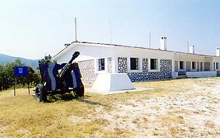
Fort Roupel is a fortress at the north border of Central Macedonia, Greece, built in 1914. It became part of the fortifications of the Metaxas Line in the 1930s and became famous for its defence during the German invasion of Greece in April 1941.

Olympiada is a town in the northeastern part of the peninsula of Chalkidice, Greece, with 649 inhabitants in the 2001 census. It is a municipal district of the same name, within the municipality of Stagira-Akanthos. Main occupation of its residents is tourism and fishing. The distance from Ierissos is 35 km and 90 from Thessaloniki. Approximately 700 meters from it lies the archaeological site of ancient Stagira. The area is declared as a protected zone by the Natura 2000 programme.
Pinewood - The American International School is an American international school in Thermi, Thessaloniki regional unit, Greece. It serves grades Pre-Kindergarten through 12 and uses English as its language of instruction.


