Perinthus or Perinthos was a great and flourishing town of ancient Thrace, situated on the Propontis. It lay 22 miles west of Selymbria, on a small peninsula of the bay which bears its name, and was built like an amphitheatre, on the declivity of a hill. It was originally a Samian colony, and, according to George Syncellus, was founded about 599 BCE. German archaeologist Theodor Panofka, however, makes it contemporary with Samothrace, that is about 1000 BCE. It was particularly renowned for its obstinate defence against Philip V of Macedon At that time it appears to have been a more important and flourishing town even than Byzantium; and being both a harbour and a point at which several main roads met, it was the seat of an extensive commerce. This circumstance explains the reason why so many of its coins are still extant; from which we learn that large and celebrated festivals were held here. According to John Tzetzes, it bore at an early period the name of Mygdonia (Μυγδονία) and at a later one, but not before the fourth century CE, it assumed the name of Heraclea or Heracleia (Ἡράκλεια); which we find sometimes used alone, and sometimes with additions Heraclea Thraciae and Heraclea Perinthus. Justinian restored the old imperial palace, and the aqueducts of the city. Coins of Perinthus have also survived.

Elis or Ilia is one of the regional units of Greece. It is part of the region of Western Greece. It is situated in the western part of the Peloponnese peninsula. Its capital is Pyrgos.
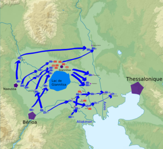
The Battle of Yenidje or Yenice or Battle of Giannitsa, was a battle between the Greek Army and the Ottoman Army on October 19–20 1912, during the First Balkan War. The Greek Army defeated the Ottomans, opening the way towards Thessaloniki and capturing Yenidje.

Greek National Road 2 is a single carriageway with at-grade intersections, located in the regions of West Macedonia, Central Macedonia and East Macedonia and Thrace. It connects the Albanian border near Florina with the Turkish border near Alexandroupoli. Its section east of Thessaloniki has been replaced by the new A2 motorway. The section between the Albanian border and Thessaloniki is part of European route E86.
Greek National Road 67 is a limited access road in northern Greece. It connects the Motorway 25 with the Thessaloniki International Airport.

Greek National Road 13 is a single carriageway road in northern Greece. It connects Katerini with the Greek National Road 3 at Mikro Eleftherochori, 8 km north of Elassona.
Amantia or Abantia was an ancient Greek polis in Epirus. It occupied an important defensive position above the Aoos river valley to the east, and on the road to the coast and the Bay of Aulon, in Vlorë County of the modern-day Albania. A Greek temple, the Aphrodite temple, a theatre, and a stadium have also been found in the city. The name for an inhabitant was Amantieus.

The I Army Corps was an army corps of the Hellenic Army, founded in December 1913. Originally based in Athens and covering southern Greece, since 1962 it was responsible for covering Greece's northwestern borders. It was disbanded in 2013.

The First Hellenic Republic is a historiographical term for the provisional Greek state during the Greek War of Independence against the Ottoman Empire. It is used to emphasize the constitutional and democratic nature of the revolutionary regime prior to the establishment of the independent Kingdom of Greece, and associate this period of Greek history with the later Second and Third Republics.
Koyasu Station is a railway station operated by the Keikyū Keikyū Main Line located in Kanagawa-ku, Yokohama, Kanagawa Prefecture, Japan. It is located 19.3 rail kilometers from the northern terminus of the Keikyū Main Line at Shinagawa Station, in Tokyo.

Agia Lavra is a monastery near Kalavryta, Achaea, Greece. It was built in 961 AD, on Chelmos Mountain, at an altitude of 961 meters, and can be described as the symbolic birthplace of modern Greece. It stands as one of the oldest monasteries in the Peloponnese.

East Greenwich Pleasaunce is a public park in East Greenwich, in south-east London. It is situated to the north side of the railway line between Maze Hill and Westcombe Park railway stations and south of the A206 Woolwich Road.

Greek National Road 20 is a single carriageway road in northwestern Greece. It links the cities of Ioannina and Kozani via Konitsa and Siatista. It passes through the Ioannina, Kastoria and the Kozani regional units. Since the opening of the A2, it is no longer the fastest connection between Kozani and Ioannina. The section between Ioannina and Kalpaki is part of the European route E853.

The Battle of Gravia Inn was fought between Greek revolutionaries and the Ottoman Empire during the Greek War of Independence. The Greek leader, Odysseas Androutsos, with a group of 120 men repulsed an Ottoman army numbering 10,000 men and artillery under the command of Omer Vrioni.

Nine Elms Railway Station in the London district of Battersea was opened on 21 May 1838 as the London terminus of the London & Southampton Railway which on the same day became the London and South Western Railway. The building in the neo-classical style was designed by Sir William Tite. The station was inconveniently situated for travel to central London, with the necessity to complete the journey by road or by the steam boats connecting the station to points between Vauxhall and London Bridge.
The Battle of Doliana took place during the Greek War of Independence on 18 May 1821.

Egnatia Street is the main commercial street in downtown Thessaloniki. The road is named for the Roman-era Via Egnatia which passed near the city. Lined with shops and office buildings, it is one of the busiest streets of Thessaloniki.

Greek National Road 15 is a single carriageway road in northern Greece. It connects Agios Germanos, near the border with the Republic of Macedonia, with the Greek National Road 6 near Kalampaka. It passes through Kastoria, Siatista and Grevena.

Greek National Road 65 is a national highway of Greece. It connects the Greek National Road 2 at Diavata, a northwestern suburb of Thessaloniki, with Kilkis. Most of the National-Road has been upgraded to a Motor-Road, connecting Thessaloniki via Kilkis with Doirani, the eastern border of Greece and North Macedonia.

The ChS3 is a type of 4-axle passenger direct current electric locomotive, manufactured in 1961, which was used in the Soviet Union and the Russian Federation. In 1960, due to the increase in passenger trains, the Skoda factory was ordered to design and produce a more powerful locomotive type than the ChS1. The plant's management decided to base the new electric locomotives on the ChS1 class of locomotive. Therefore, the more powerful AL4846eT traction motors and traction drive were installed in the experimental ChS1 locomotive. Thus, the ChS3 design was an improved version of the ChS1.