Euboea or Evia; Greek: Εύβοια, Evvoia, pronounced [ˈevia]; Ancient Greek: Εὔβοια, Eúboia, [eúboja]) is the second-largest Greek island in area and population, after Crete. The narrow Euripus Strait separates it from Boeotia in mainland Greece. In general outline it is a long and narrow island; it is about 180 kilometres (110 mi) long, and varies in breadth from 50 kilometres (31 mi) to 6 kilometres (3.7 mi). Its geographic orientation is from northwest to southeast, and it is traversed throughout its length by a mountain range, which forms part of the chain that bounds Thessaly on the east, and is continued south of Euboea in the lofty islands of Andros, Tinos and Mykonos.
Eretria is a town in Euboea, Greece, facing the coast of Attica across the narrow South Euboean Gulf. It was an important Greek polis in the 6th/5th century BC, mentioned by many famous writers and actively involved in significant historical events.

Styra is a village and a former municipality on the island Euboea, Greece. Since the 2011 local government reform it is part of the municipality Karystos, of which it is a municipal unit. The municipal unit has an area of 188.583 km2. It is located in the southern part of Euboea, facing the eastern shore of Attica across the South Euboean Gulf. Nowadays it can be reached by ferryboat from the tiny harbor of Agia Marina, as well as by bridge from Chalcis.
Above the port there is a hill where the church of Saints Kostantine and Helen is situated with a panoramic view of the coast and Stouronisi .
Styra is a very popular destination for Athenians during the summer period.
After the collapse of the Iron Curtain, Albanians migrated into the area. The town takes its name from the ancient town of Styra.

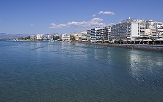
Karystos or Carystus is a small coastal town on the Greek island of Euboea. It has about 5,000 inhabitants. It lies 129 km south of Chalkis. From Athens it is accessible by ferry via Marmari from the port of Rafina. Its urban plan was laid out by the renowned Bavarian civil engineer Bierbach, in the middle of the 19th century, near the site of the ancient city of Carystus.
The Lelantine War is the modern name for a military conflict between the two ancient Greek city states Chalcis and Eretria in Euboea which took place in the early Archaic period, between c. 710 and 650 BC. The reason for war was, according to tradition, the struggle for the fertile Lelantine Plain on the island of Euboea. Due to the economic importance of the two participating poleis, the conflict spread considerably, with many further city states joining either side, resulting in much of Greece being at war. The historian Thucydides describes the Lelantine War as exceptional, the only war in Greece between the mythical Trojan War and the Persian Wars of the early 5th century BC in which allied cities rather than single ones were involved.
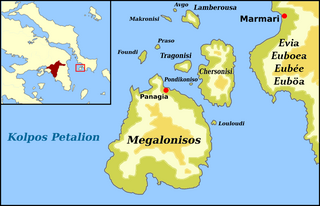
Marmari is a village and a former municipality in Euboea, Greece, in the southeastern end of the island. Since the 2011 local government reform it is part of the municipality Karystos, of which it is a municipal unit. The municipal unit has an area of 241.332 km2. The Greek National Road 44 runs through Marmari. There are ferry routes with the mainland port of Rafina. The mountains dominate the east. Its main economy are businesses and agriculture. Marmari is located SE of Chalkida, E of Rafina and west of Karystos.
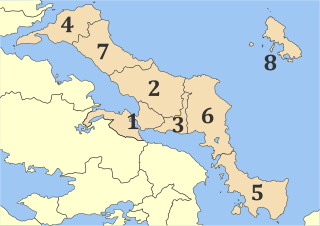
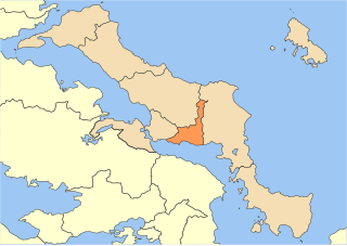
Euboea is one of the regional units of Greece. It is part of the administrative region of Central Greece. It consists of the islands of Euboea and Skyros, as well as a 395 km² area on the Greek mainland. Its land area is 4,167.449 km², whereas the total land area of the municipalities actually on the island Euboea is 3,684.848 km², which includes that of numerous small offshore islets near Euboea's southern tip.
Callias of Chalcis, son of Mnesarchus, together with his brother Taurosthenes, succeeded his father as tyrants of Chalcis. Callias formed an alliance with Philip of Macedon against Plutarch, tyrant of Eretria, with the view of extending his authority over the whole of Euboea, a design which, according to Aeschines, he disguised as a plan for uniting in one league the states of the island and establishing a general Euboean congress based at Chalcis.
Aliveri is a town and a community in the island of Evoia, Greece. It is part of the municipal unit Tamyneoi, and the seat of the municipality Kymi-Aliveri. Aliveri is situated in the western part of the island, on the South Euboean Gulf. It is 13 km southwest of Avlonari, 14 km east of Amarynthos and 39 km east of Chalcis. The Greek National Road 44 passes through the town. The community Aliveri consists of the town Aliveri and the villages Anthoupoli, Katakalos, Latas and Milaki.
The North Euboean Gulf is a gulf of the Aegean Sea. It separates the northern part of the island Euboea from the mainland of Central Greece. The narrow Euripus Strait, near Chalcis, connects the gulf to the south with the South Euboean Gulf. To the north, the gulf is connected with the Malian Gulf. The total length is approximately 60 km and its width ranges from approximately 10 to 20 km. It runs diagonally from northwest to southeast.

The South Euboean Gulf is a gulf in Central Greece, between the island of Euboea and the Greek mainland. With a total length of approximately 50 km and a width of 10 to 20 km, it stretches nearly diagonally from northwest to southeast, from the Euripus Strait, which connects it to the North Euboean Gulf, to the Petalies Gulf near Agia Marina in the south.
The Petalioi Gulf is a gulf of the Aegean Sea, Greece. It stretches between the east coast of Attica and the south tip of the island Euboea. It takes its name from the Petalioi islands, that are situated in the northeastern part of the Gulf, off the Euboean coast. The Petalioi Gulf is connected to the South Euboean Gulf to the north. Its length is approximately 50 km long from north to south and its width is approximately 5 km in the north to about 50 km in the south. There are several uninhabited islands in the gulf, including the Petalioi and Makronisos. Promontories include Strongylo and Vigla in the island of Euboea.
Amarynthos, is a coastal town and a former municipality in Euboea, Greece. Since the 2011 local government reform it is part of the municipality Eretria, of which it is a municipal unit. The municipal unit has an area of 109.909 km2. In 2011 its population was 3,672 for the town and 6,723 for the municipal unit. The Amarynthos is 8 km east of Eretria, 27 km southeast of Chalcis, 63 km northwest of Karystos and 10 km north of Kalamos, across the gulf. The Greek National Road 44 passes through the town.

Mount Olympus is a mountain in the east central part of the island of Euboea, Greece. Its maximum elevation is 1,172 m. It is not the highest mountain of Euboea, that is 1,743 m high Dirfi, 16 km to the north. The Olympus is 10 km north of Amarynthos, 11 km northeast of Eretria and 24 km east of the city of Chalcis. There are forests on the northern slopes while most of the mountain range is covered with grassland and bushes.
Greek National Road 77 is a national highway on the island of Euboea, Greece. It connects Chalcis with Aidipsos via Agia Anna and Istiaia.
Kymi is a coastal town and a former municipality in the island of Euboea, Greece, named after an ancient Greek place of the same name. Since the 2011 local government reform it is part of the municipality Kymi-Aliveri, of which it is a municipal unit. The municipal unit has an area of 167.616 km2. The ancient Euboean Kyme is mentioned as a harbor town related to the more prominent poleis of Chalkis and Eretria in antiquity. Together with these, it is sometimes named as the founding metropolis of the homonymous Kymē (Cumae) in Italy, an important early Euboean colony, which was probably named after it.
Styra was a town of ancient Euboea, on the west coast, north of Carystus, and nearly opposite the promontory of Cynosura in Attica. The town stood near the shore in the inner part of the bay, in the middle of which is the island Aegileia, now called Stouronisi. Styra is mentioned by Homer along with Carystus in the Catalogue of Ships in the Iliad. Its inhabitants were originally Dryopians, though they denied this origin, and claimed to be descended from the deme of Steiria in Attica. In the First Persian War (490 BCE) the Persians landed at Aegileia, which belonged to Styra, the prisoners whom they had taken at Eretria. In the Second Persian War (480-479 BCE) the Styrians fought at the battles of Artemisium, Salamis, and Plataeae. They sent two ships to the naval engagements, and at Plataeae they and the Eretrians amounted together to 600 men. They afterwards became the subjects of Athens, and paid a yearly tribute of 1200 drachmae. The Athenian fleet was stationed here in 356 BCE. Strabo relates that the town was destroyed in the "Maliac War" by the Athenian Phaedrus, and its territory given to the Eretrians; but as the Maliac War is not mentioned elsewhere, we ought probably to substitute Lamian War for it.