
Continental Greece, colloquially known as Roúmeli (Ρούμελη), is a traditional geographic region of Greece. In English the area is usually called Central Greece, but the equivalent Greek term is more rarely used.

Aetolia-Acarnania is one of the regional units of Greece. It is part of the geographic region of Central Greece and the administrative region of West Greece. A combination of the historical regions of Aetolia and Acarnania, it is the country's largest regional unit. Its capital is Missolonghi for historical reasons, with its biggest city and economic centre at Agrinio. The area is now connected with the Peloponnese peninsula via the Rio-Antirio Bridge. The surrounding regional units take in Arta in Epirus, a narrow length bordering Karditsa of Thessaly, Evrytania to the northeast, and Phocis to the east.

Evrytania is one of the regional units of Greece. It is part of the region of Central Greece. Its capital is Karpenisi.
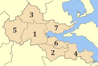
Phthiotis is one of the regional units of Greece. It is part of the administrative region of Central Greece. The capital is the city of Lamia. It is bordered by the Malian Gulf to the east, Boeotia in the south, Phocis in the south, Aetolia-Acarnania in the southwest, Evrytania in the west, Karditsa regional unit in the north, Larissa regional unit in the north, and Magnesia in the northeast. The name dates back to ancient times. It is best known as the home of Achilles.

Greek National Road 48 is a single carriageway road in central Greece. It connects the Greek National Road 5 at Antirrio with the town Livadeia, passing through Naupactus and Delphi. The section between Antirrio and Itea is part of European route E65. The GR-48 passes through the regional units Aetolia-Acarnania, Phocis and Boeotia.

The Spercheios, also known as the Spercheus from its Latin name, is a river in Phthiotis in central Greece. It is 80 km (50 mi) long, and its drainage area is 1,830 km2 (710 sq mi). It was worshipped as a god in the ancient Greek religion and appears in some collections of Greek mythology. In antiquity, its upper valley was known as Ainis. In AD 997, its valley was the site of the Battle of Spercheios, which ended Bulgarian incursions into the Byzantine Empire.

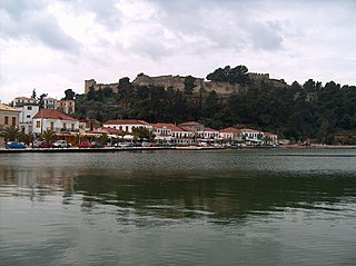
Karpenisi is a town in central Greece. It is the capital of the regional unit of Evrytania. Karpenisi is situated in the valley of the river Karpenisiotis (Καρπενησιώτης), a tributary of the Megdovas, in the southern part of the Pindus Mountains. Mount Tymfristos lies directly to the north of the town, and the foothills of mount Kaliakouda are in the south. Karpenisi has a ski resort and is a popular destination, especially during winter. It is called Switzerland of Greece for the resemblance with the mountainous country and its beauty, atypical for a Mediterranean place.

Makrakomi is a town and a municipality in the western part of the Phthiotis regional unit, in Greece. The seat of the municipality is the town Spercheiada.

Makryneia is a former municipality in Aetolia-Acarnania, West Greece, Greece. Since the 2011 local government reform it is part of the municipality Agrinio, of which it is a municipal unit. The municipal unit has an area of 149.687 km2. Population 3,681 (2011). The seat of the municipality was in Gavalou. The municipal unit is located south and southeast of Lake Trichonida, and northwest of the mountain Arakynthos. There are farmlands near the lake shore, and forests on the mountain slopes. Makryneia is southeast of Agrinio, northeast of Missolonghi and northwest of Naupactus.
Aspropotamos is a former municipality in the northwestern part of Evrytania, Greece. Since the 2011 local government reform it is part of the municipality Agrafa, of which it is a municipal unit. The municipal unit has an area of 125.954 km2. Population 1,581 (2011). The seat of the municipality was in Raptopoulo. Aetolia-Acarnania is to the west and the Karditsa regional unit to the north. Aspropotamos is located west-southwest of Karditsa, northwest of Karpenisi and north-northeast of Agrinio.

Lake Kremasta is the largest artificial lake in Greece. The construction of Kremasta Dam was completed in 1965 concentrating waters from four rivers: Acheloos, Agrafiotis, Tavropos and Trikeriotis. The water that is accumulated in the artificial lake is about 3.8 cubic kilometres (3,100,000 acre⋅ft). It prevents flooding of the Acheloos, and supplies electricity to the national grid during peaks of demand. The power station at the dam is the biggest hydroelectric plant in Greece. It was constructed in 1966 and is owned by the Public Power Corporation of Greece. At the time of its construction, it was the largest earth-filled hydroelectric project in Europe.

The Megdovas, also known as Tavropos, is a river that flows through the Karditsa and Evrytania regional units, Greece. It is 78 km (48 mi) long.
Vonitsa is a town in the northwestern part of Aetolia-Acarnania in Greece, seat of the municipality of Aktio-Vonitsa. Population 4,916 (2011). The beach town is situated on the south coast of the Ambracian Gulf, and is dominated by a Venetian fortress on a hill. Vonitsa is 13 kilometres southeast of Preveza, 18 kilometres northeast of Lefkada (city) and 90 kilometres northwest of Agrinio. The Greek National Road 42 passes through Vonitsa.

Panaitoliko is a mountain range in the northeastern part of Aetolia-Acarnania and southwestern Evrytania, in western Greece. Its highest summit, Kyra Vgena, is the highest point of Aetolia-Acarnania at 1,924 m. Its length is approximately 25 km long from east to west and its width is approximately 15 km wide. The nearest mountains are Kaliakouda to the northeast, the mountains of Nafpaktia to the southeast and Valtou to the northwest. Lake Trichonida lies to the south. The Panaitoliko extends from the Acheloos valley in the northwest to the Evinos valley in the east. There are forests in the lower areas, and grasslands in the higher elevations.

Tymfristos is a mountain in the eastern part of Evrytania and the western part of Phthiotis, Greece. The mountain is a part of the Pindus mountain range. The elevation of its highest peak, Velouchi, is 2,315 m. The nearest mountains are Kaliakouda and Panaitoliko to the south, Vardousia to the southeast and the Agrafa mountains to the north. It is drained by the river Spercheios to the east and by tributaries of the Acheloos to the west.

Trichonida Province was one of the provinces of the Aetolia-Acarnania Prefecture, Greece. Its territory corresponded with that of the current municipalities Agrinio and Thermo. It was abolished in 2006.
Dikastro, meaning "two castles", is a small village in the northwest of Phthiotis Prefecture in Central Greece, very close to the borders with Evrytania and Karditsa. Built on the verdant rocky landscape between Mounts Tymfristos and Mavrorachi, it is located 35 km away from Karpenisi, 61 km from Lamia and 275 km from Athens. It stands at an altitude of 850m and comprises two settlements, separated by creek Dikastriotis, one of the main streams flowing onto the river Spercheios.
Makyneia is a seaside village and a community in Nafpaktia, Aetolia-Acarnania, Greece.


