Rury, Lublin

Last updated
Rury
Lublin District
Nadbystrzycka widok ze sciezki rowerowej 2.JPG
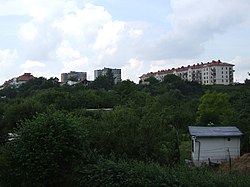
View upon allotments and apartments by Nadbystrzycka Street
Dzielnice Lublina Rury.svg
Location of Rury within Lublin
Coordinates: 51°14′19″N22°30′59″E / 51.23861°N 22.51639°E / 51.23861; 22.51639
CountryFlag of Poland.svg Poland
Voivodeship Lublin
County/City Lublin
Area
  Total
3.61 km2 (1.39 sq mi)
Population
 (2016)
  Total
30,093 [1]
  Density8,340/km2 (21,600/sq mi)
Time zone UTC+1 (CET)
  Summer (DST) UTC+2 (CEST)
Postal code
80-506
80-528
Area code +48 58
Vehicle registration LU

Rury is one of the quarters of the city of Lublin, Poland located in the west-central part of the city. The district grew upon the hillside, former city fields, extending to Konopnica. From February 23, 2006 the district became an administrative region of Lublin.

History

Memorial and mass grave of Poles murdered by the Germans in Rury in 1940 Pomnik ofiar egzekucji w Rurach Jezuickich w Lublinie 01.jpg
Memorial and mass grave of Poles murdered by the Germans in Rury in 1940

During the German occupation of Poland (World War II), in 1940, the Germans murdered about 500 Poles from the region in several massacres in the settlement of Rury Jezuickie, now located within the district. [2] Among the victims were activists, students, doctors, engineers, local officials, judges, lawyers, military officers, members of the Sejm (Polish parliament), etc. [2] There is a memorial at the site.

References

  1. "BIP Urząd Miasta Lublin". bip.lublin.eu. Retrieved 20 August 2017.
  2. 1 2 Wardzyńska, Maria (2009). Był rok 1939. Operacja niemieckiej policji bezpieczeństwa w Polsce. Intelligenzaktion (in Polish). Warszawa: IPN. pp. 265–266.