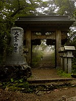
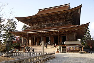
Mount Kōya is a large temple settlement in Wakayama Prefecture, Japan to the south of Osaka. In the strictest sense, Mount Kōya is the mountain name (sangō) of Kongōbu-ji Temple, the ecclesiastical headquarters of the Koyasan sect of Shingon Buddhism.

Kihō is a town located in Mie Prefecture, Japan. As of September 2012, the town had an estimated population of 11,454 and a population density of 144 persons per km2. The total area was 79.66 km2.
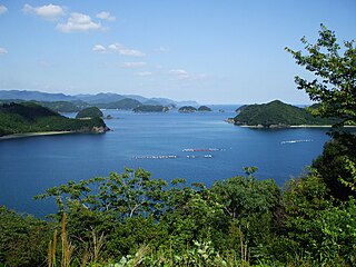
The Kii Peninsula is the largest peninsula on the island of Honshū in Japan. It is named after the ancient Kii Province.
Kihoku is a town located in Mie Prefecture, Japan. As of September 2012, the town had an estimated population of 17,885 and a population density of 69.6 persons per km2. The total area was 257.01 km2.

Mount Ōmine, is a sacred mountain in Nara, Japan, famous for its three tests of courage.

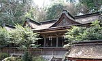
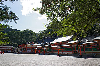
Kumano Nachi Taisha (熊野那智大社) is a Shinto shrine and part of the UNESCO-designated World Heritage Sacred Sites and Pilgrimage Routes in the Kii Mountain Range of Japan. The Kumano Kodō route connects it to other sites under the same classification, which are primarily located in Wakayama Prefecture, Japan. The four sites on the route, classified as pilgrimage destinations and World Heritage Sites, are: 1) Nachi Taisha; 2) Hongū Taisha; 3) Hayatama Taisha; 4) Koya-san.

The Kumano Kodō (熊野古道) is a series of ancient pilgrimage routes that crisscross the Kii Hantō, the largest peninsula of Japan. These trails were used by pilgrims to "Kumano Sanzan" (熊野三山) or the Three Grand Shrines of Kumano: Kumano Hongū Taisha (熊野本宮大社), Kumano Nachi Taisha (熊野那智大社) and Kumano Hayatama Taisha (熊野速玉大社).
Kumano Hayatama Taisha (熊野速玉大社) is a Shinto shrine located in Shingu, Wakayama Prefecture, on the shores of the Kumanogawa in the Kii Peninsula of Japan. It is included as part of the Kumano Sanzan in the UNESCO World Heritage site "Sacred Sites and Pilgrimage Routes in the Kii Mountain Range". The three Kumano Sanzan shrines are the Sōhonsha of all Kumano shrines, lie at between 20 and 40 km of distance one from the other and are connected by the pilgrimage route known as "Kumano Sankeimichi" (熊野参詣道).
Kii Mountains is a mountainous region covering most of the Kii Peninsula. They lie south of the Japan Median Tectonic Line (MTL) in Wakayama, Nara, and Mie prefectures. The mountains are arranged roughly northeast to southwest.

Kinpu Shrine is a Shinto shrine located in Yoshino district, Nara Prefecture, Japan. The honden, or main hall, is constructed in the nagare-zukuri style.
Kinpusen-ji is the head temple of a branch of the Shugendō religion called Kinpusen-Shugendō in Yoshino district, Nara Prefecture, Japan. According to tradition, it was founded by En no Gyōja, who propagated a form of mountain asceticism drawing from Shinto and Buddhist beliefs. Along with Ōminesan-ji Temple, it is considered the most important temple in Shugendō.
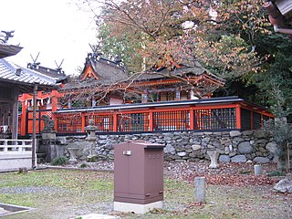
Niutsuhime Shrine or Nibutsuhime Shrine is a Shinto shrine in Ito district, Wakayama Prefecture, Japan. The main hall is partially built in the kasuga-zukuri style.
Niukanshōfu Shrine or Niukanshōbu Shrine is a Shinto shrine in Ito district, Wakayama Prefecture, Japan.

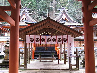
Ōminesan-ji is an important temple of the Shugendō religion in Yoshino district, Nara prefecture, Japan. It is located at the peak of Mount Ōmine, or Sanjōgatake. According to tradition, it was founded by En no Ozunu, the founder of Shugendō, a form of mountain asceticism drawing from Buddhist and Shinto beliefs. Along with Kinpusen-ji Temple, it is considered the most important temple in Shugendō.

Fudarakusan-ji is Tendai temple of the Higashimuro district, Wakayama prefecture, Japan. The name of temple comes from mount Potalaka. It is said to have been founded by Ragyō Shōnin, a monk from India.
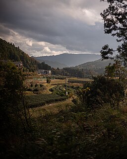
The Kumano Region is a region situated on the southern part of the Kii Peninsula in Japan, former Muro District. It includes parts of Mie Prefecture, Wakayama Prefecture, and Nara Prefecture.
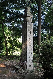
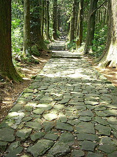
Kōyasan chōishi-michi (高野山町石道) is a twenty-four kilometre path with a stone marker (ishi) every 109 metres (chō) leading to Kōyasan, Wakayama Prefecture, Japan. Created by Kūkai and within the Kōyasan Chōishi-michi Tamagawa Prefectural Park (高野山町石道玉川峡県立自然公園), it forms part of the UNESCO World Heritage Site: Sacred Sites and Pilgrimage Routes in the Kii Mountain Range.
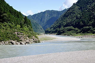
The Kumano River is a river in the Kii Peninsula of central Japan, located in Nara, Wakayama and Mie Prefectures. It is 183 kilometres (114 mi) long and has a watershed of 2,630 square kilometres (1,020 sq mi).
The Iseji (伊勢路) is part of the Kumano Kodõ (熊野古道) pilgrimage route system. It links the Ise Grand Shrine (伊勢神宮) with the three great shrines of Kumano — Hongu, Nachi, and Hayatama Shrines.