Sam Ford Fiord

Last updated
Sam Ford Fiord
Location map Nunavut 2.png
Red pog.svg
Sam Ford Fiord
Location in Nunavut
Location Baffin Island
Coordinates 70°30′01″N071°09′00″W / 70.50028°N 71.15000°W / 70.50028; -71.15000 Coordinates: 70°30′01″N071°09′00″W / 70.50028°N 71.15000°W / 70.50028; -71.15000
Ocean/sea sources Baffin Bay
Basin  countries Nunavut, Canada
Max. length 110 km (68 mi)
Max. width 19 km (12 mi)

Sam Ford Fiord is an isolated, elongated Arctic fjord on Baffin Island's northeastern coast in the Qikiqtaaluk Region of Nunavut, Canada. [1] The Inuit settlement of Pond Inlet is 320 km (200 mi) to the northwest and Clyde River is 80 km (50 mi) to the east.

Arctic polar region on the Earths northern hemisphere

The Arctic is a polar region located at the northernmost part of Earth. The Arctic consists of the Arctic Ocean, adjacent seas, and parts of Alaska, Finland, Greenland (Denmark), Iceland, Northern Canada, Norway, Russia and Sweden. Land within the Arctic region has seasonally varying snow and ice cover, with predominantly treeless permafrost -containing tundra. Arctic seas contain seasonal sea ice in many places.

Fjord A long, narrow inlet with steep sides or cliffs, created by glacial activity

Geologically, a fjord or fiord is a long, narrow inlet with steep sides or cliffs, created by a glacier. There are many fjords on the coasts of Alaska, Antarctica, British Columbia, Chile, Greenland, the Faroe Islands, Iceland, Kamchatka, the Kerguelen Islands, New Zealand, Norway, Novaya Zemlya, Labrador, Nunavut, Newfoundland, Quebec, Scotland, South Georgia Island, and Washington state. Norway's coastline is estimated at 29,000 kilometres (18,000 mi) with nearly 1,200 fjords, but only 2,500 kilometres (1,600 mi) when fjords are excluded.

Baffin Island island of Canada

Baffin Island, in the Canadian territory of Nunavut, is the largest island in Canada and the fifth-largest island in the world. Its area is 507,451 km2 (195,928 sq mi) and its population is about 11,000. It is located in the region of 70° N and 75° W.

Contents

This fjord is reputed for the harsh beauty of its landscapes with rocky cliffs rising steeply from the shore. [2] It is also a popular place with climbers. [3]

Mountaineering sport of mountain climbing

Mountaineering is the set of activities that involves ascending mountains. Mountaineering-related activities include traditional outdoor climbing, hiking, skiing, and traversing via ferratas. Indoor climbing, sport climbing and bouldering are usually considered mountaineering as well.

History

Sam Ford Fiord had been one of the traditional hunting areas of the Inuit. [4] Sam Ford Fiord (Kangiqtualuk Uqquqti) lies on Baffin Island’s northeastern coast in the Qikiqtaaluk Region of Nunavut. It was named in memory of Sam Ford. Ford is recognized as Canada’s most outstanding Inuk linguist and died tragically in a helicopter crash.

Geography

Western shoreline of Sam Ford Fjord about 15 km (9.3 mi) from its mouth Baffin Island Northeast Coast 1997-08-07.jpg
Western shoreline of Sam Ford Fjord about 15 km (9.3 mi) from its mouth

Sam Ford Fiord stretches roughly from NNE to SSW for about 110 km (68 mi). Its mouth, located between the Remote Peninsula and Erik Point, is over 18 km (11 mi) wide, the width of the fjord narrowing gradually to an average of 3 km (1.9 mi) about 50 km (31 mi) inland. Walker Arm is a tributary fjord branching west from the fjord's western shore about 45 km (28 mi) to the south of its mouth. The Stewart Valley —with its awesome Sail Peaks stretches northwards from Walker Arm's NW corner and connects with the neighbouring Gibbs Fiord. Swiss Bay is a smaller inlet on the eastern shore of Sam Ford Fiord connecting through Ottawa Creek and the Revoir Pass with the inner reaches of neighbouring Eglinton Fiord in the east. [5] The Sam Ford River discharges its waters at the head of the fjord further south [6] and Heimen Island is located within the inner section of the fjord off a small bay 15 km (9.3 mi) to the NNE of the river's mouth. [5]

Remote Peninsula

The Remote Peninsula is a peninsula located on the eastern coast of Baffin Island. It is part of the Qikiqtaaluk Region of the Canadian territory of Nunavut. The Inuit settlement of Pond Inlet is 295 km (183 mi) to the northwest and Clyde River is 90 km (56 mi) to the southeast.

Walker Arm Walker Arm Fiord

The Walker Arm is a tributary fjord of the Sam Ford Fjord located on the northeast coast of Baffin Island in the Qikiqtaaluk region in Nunavut, Canada. The Inuit settlement of Pond Inlet is about 325 km to the northeast and that of Clyde River is about 100 km to the east.

Revoir Pass

Revoir Pass is a mountain pass in the central Baffin Mountains, Nunavut, Canada. It is named after the Revoir River.

Sam Ford Fiord is known for its glaciers and its awe-inspiring stark granite cliffs, rising steeply from its shores to heights up to 1,500 m (4,900 ft) above sea level in the area near Swiss Bay. Among the most impressive summits by the fjord Beluga Mountain, [7] Rock Tower, [8] Walrus Head, Broad Peak, Ottawa Peak, Sikunga Mountain, Turnagain Peak, and the Paalik Peak deserve mention. [5]

Granite A common type of intrusive, felsic, igneous rock with granular structure

Granite is a common type of felsic intrusive igneous rock that is granular and phaneritic in texture. Granites can be predominantly white, pink, or gray in color, depending on their mineralogy. The word "granite" comes from the Latin granum, a grain, in reference to the coarse-grained structure of such a holocrystalline rock. Strictly speaking, granite is an igneous rock with between 20% and 60% quartz by volume, and at least 35% of the total feldspar consisting of alkali feldspar, although commonly the term "granite" is used to refer to a wider range of coarse-grained igneous rocks containing quartz and feldspar.

Cliff A vertical, or near vertical, rock face of substantial height

In geography and geology, a cliff is a vertical, or nearly vertical, rock exposure. Cliffs are formed as erosion landforms by the processes of weathering and erosion. Cliffs are common on coasts, in mountainous areas, escarpments and along rivers. Cliffs are usually formed by rock that is resistant to weathering and erosion. Sedimentary rocks most likely to form cliffs include sandstone, limestone, chalk, and dolomite. Igneous rocks such as granite and basalt also often form cliffs.

A massive cliff on the eastern shore located at a bend in the fjord 49 km from its mouth at 70°37′51.82″N70°55′0.33″W / 70.6310611°N 70.9167583°W / 70.6310611; -70.9167583 has a vertical wall dropping from a height of 1368 m to the fjord's waters. [9]

See also

Related Research Articles

Frobisher Bay bay

Frobisher Bay is an inlet of the Labrador Sea in the Qikiqtaaluk Region of Nunavut, Canada. It is located in the southeastern corner of Baffin Island. Its length is about 230 km (140 mi) and its width varies from about 40 km (25 mi) at its outlet into the Labrador Sea to roughly 20 km (12 mi) towards its inner end.

Grise Fiord Hamlet in Nunavut, Canada

Grise Fiord, is an Inuit hamlet in the Qikiqtaaluk Region in the territory of Nunavut, Canada. Despite its low population, it is the largest community on Ellesmere Island. It is also one of the coldest inhabited places in the world, with an average yearly temperature of −16.5 °C (2.3 °F).

Pangnirtung Place in Nunavut, Canada

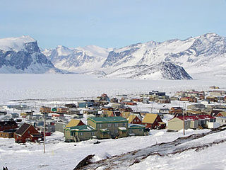
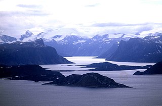
Pangnirtung is an Inuit hamlet, Qikiqtaaluk Region, in the Canadian territory of Nunavut, located on Baffin Island. As of the 2016 census the population was 1,481, an increase of 3.9% from the 2011 census. The area of the town is 7.77 km2 (3.00 sq mi). Pangnirtung is situated on a coastal plain at the coast of Pangnirtung Fjord, a fjord which eventually merges with Cumberland Sound. As of January 2014, the mayor is Mosesee Qappik.

Qikiqtaaluk Region Region of Nunavut, Canada

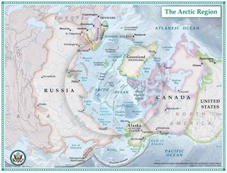
The Qikiqtaaluk Region, Qikiqtani Region or Baffin Region is the easternmost administrative region of Nunavut, Canada. Qikiqtaaluk is the traditional Inuktitut name for Baffin Island. Although the Qikiqtaaluk Region is the most commonly used name in official contexts, several notable public organisations, including Statistics Canada prefer the older term Baffin Region.

Sirmilik National Park

Sirmilik National Park is a protected area located in Qikiqtaaluk, Nunavut, Canada, established in 1999. Situated within the Arctic Cordillera, the park is composed of three areas: most of Bylot Island with the exception for a few areas that are Inuit-owned lands, Oliver Sound, and Baffin Island's Borden Peninsula. Much of the park is bordered by water.

Arctic Cordillera mountain range

The Arctic Cordillera is a vast, deeply dissected chain of mountain ranges extending along the northeastern flank of the Canadian Arctic Archipelago from Ellesmere Island to the northeasternmost part of the Labrador Peninsula in northern Labrador and northern Quebec, Canada. It spans most of the eastern coast of Nunavut with high glaciated peaks rising through icefields and some of Canada's largest ice caps, including the Penny Ice Cap on Baffin Island. It is bounded to the east by Baffin Bay, Davis Strait and the Labrador Sea while its northern portion is bounded by the Arctic Ocean.

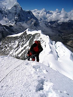
Polar Sun Spire is a peak in Beluga Mountain in the Sam Ford Fjord of Baffin Island, Canada. The spire is notable for its spectacular 1,300 m (4,300 ft) north face and has been the scene of some amazing epic climbs. The first ascent was made in 1996 by Mark Synnott, Jeff Chapman and Warren Hollinger and involved a tremendous effort. The team spent a full month on the climb and summited after 36 consecutive nights in a portaledge. They encountered difficulties up to A4 and named their 34-pitch route "The Great and Secret Show." A Norwegian team established another impressive line in 2000.

Etah, Greenland Place in Greenland, Kingdom of Denmark

Etah is an abandoned settlement in the Qaasuitsup municipality in northern Greenland. It was a starting point of discovery expeditions to the North Pole and the landing site of the last migration of the Inuit from the Canadian Arctic.

Ukpik Peak mountain in Canada

Ukpik Peak is a mountain associated with the Baffin Mountains on Baffin Island, Nunavut, Canada.

Adams Island (Nunavut) island in Canada

Adams Island is an uninhabited island in the Qikiqtaaluk Region of Nunavut, Canada. The island is located in Baffin Bay off the northeastern coast of Baffin Island in the Canadian Arctic Archipelago. Nearby are Dexterity Island (northeast), Dexterity Fiord and Baffin Island (east), Tromso Fiord (south), Paterson Inlet (west), Bergesen Island (northwest), and Isbjorn Strait (north).

Scott Inlet is a body of water in the Qikiqtaaluk Region of Nunavut, Canada. It is an arm of Baffin Bay. Scott Island lies in its middle. At its south end, it splits into Clark and Gibbs Fiords. The Inuit community of Clyde River is approximately 120 km (75 mi) to the southeast.

Clyde Inlet

Clyde Inlet is a body of water in eastern Baffin Island, Qikiqtaaluk Region, Nunavut. Its mouth opens into the Davis Strait from the west.

Buchan Gulf Arctic fjord on Baffin Island

Buchan Gulf is an isolated, elongated Arctic fjord on Baffin Island's northeastern coast in the Qikiqtaaluk Region of Nunavut, Canada. The Inuit settlement of Pond Inlet is 200 km (120 mi) to the north.

Creswell Bay is an Arctic waterway in Qikiqtaaluk Region, Nunavut, Canada. It is an arm of western Prince Regent Inlet in eastern Somerset Island. Its northeastern landmark, Fury Point, is approximately 100 km (62 mi) west of Baffin Island.

Hantzsch Island is an uninhabited island in the Qikiqtaaluk Region of Nunavut, Canada. It is located in Frobisher Bay off the southern tip of Baffin Island's Meta Incognita Peninsula and the northeastern tip of Edgell Island. The closest community is the Inuit hamlet of Sanikiluaq, 800 km (500 mi) to the west on Flaherty Island.

Scott Island (Nunavut)

Scott Island is an uninhabited island in the Qikiqtaaluk Region of Nunavut, Canada. It is located in Baffin Bay, off the eastern coast of Baffin Island, in the middle of Scott Inlet, north of the confluence of Clark Fiord and Gibbs Fiord which embrace Sillem Island.

Ayr Lake land-locked freshwater fjord

Ayr Lake is a land-locked freshwater fjord on Baffin Island's northeastern coast in the Qikiqtaaluk Region of Nunavut, Canada. The Inuit settlement of Pond Inlet is 360 km (220 mi) to the northwest and Clyde River is 35 km (22 mi) to the east.

Eglinton Fiord

Eglinton Fiord is a fjord on Baffin Island's northeastern coast in the Qikiqtaaluk Region of Nunavut, Canada. The Inuit settlement of Pond Inlet is 355 km (221 mi) to the northwest and Clyde River is 55 km (34 mi) to the east.

References

  1. "Water Features - Nunavut". The Atlas of Canada . Retrieved 2008-11-11.
  2. 4. Bericht von Bord: Die spektakulären Fjorde Kanadas (German)
  3. Greenland 2014: Baffin Island and Sam Ford Fjord for Favresse, Ditto and Villanueva
  4. Qikiqtani Truth Commission: Community Histories 1950–1975
  5. 1 2 3 "Sam Ford Fiord". Mapcarta. Retrieved 25 April 2016.
  6. NRC Sam Ford River
  7. "Beluga Mountain". Around Guides. Retrieved 25 April 2016.
  8. North America, Canada, Canadian Arctic, Beluga Mountain and Rock Tower, Sam Ford Fiord, Baffin Island, 1987 - AAJ Climbs And Expeditions, Volume 31, Issue 63 (1989) p. 163
  9. GoogleEarth

[1]

  1. https://canadac3.ca/en/expedition/the-places/sam-ford-fiord/