Sambaa K'e

Last updated

Sambaa K'e
First Nation (Designated Authority)
(Sambaa K'e Dene Band)
Trout Lake.jpg
NWT All Region Locator.svg
Red pog.svg
Sambaa K'e
Canada location map 2.svg
Red pog.svg
Sambaa K'e
Coordinates: 60°26′33″N121°14′43″W / 60.44250°N 121.24528°W / 60.44250; -121.24528 Coordinates: 60°26′33″N121°14′43″W / 60.44250°N 121.24528°W / 60.44250; -121.24528
CountryCanada
Territory Northwest Territories
Region Dehcho Region
Constituency Nahendeh
Census division Region 4
Trading post1796
SettlementLate 1960s
Government
  ChiefDolphus Jumbo
  Band ManagerRuby Jumbo
   MLA Kevin Menicoche
Area
[1]
  Land119.51 km2 (46.14 sq mi)
Elevation
495 m (1,624 ft)
Population
 (2016) [1]
  Total88
  Density0.7/km2 (2/sq mi)
Time zone UTC−07:00 (MST)
  Summer (DST) UTC−06:00 (MDT)
Canadian Postal code
X0E 1Z0
Area code(s) 867
Telephone exchange 206
- Living cost162.5 A
- Food price index144.1 B
Sources:
Department of Municipal and Community Affairs, [2]
Prince of Wales Northern Heritage Centre, [3]
Canada Flight Supplement [4]
^A 2013 figure based on Edmonton = 100 [5]
^B 2015 figure based on Yellowknife = 100 [5]

Sambaa K'e [6] (Slavey language: "place of trout"[ pronunciation? ]; formerly Trout Lake) is a "Designated Authority" [7] in the Dehcho Region of the Northwest Territories, Canada. The community is located near the Alberta border, east of Fort Liard, on the shore of the lake also known as Sambaa K'e. It has no all-weather road, but can be reached by winter road early in the year or by air (Sambaa K'e Aerodrome) year-round.

Contents

On June 21, 2016, the settlement officially changed its name from "Trout Lake" to "Sambaa K'e", its name in the Slavey language, meaning "place of trout". [6]

Demographics

Federal census population history of Sambaa K'e
YearPop.±%
197657    
198159+3.5%
198654−8.5%
1991 66+22.2%
1996 68+3.0%
2001 70+2.9%
2006 86+22.9%
2011 92+7.0%
2016 88−4.3%
2021 97+10.2%
Source: Statistics Canada
[8] [9] [10] [11] [12] [13] [14] [1] [15]
Annual population estimates
YearPop.±%
199674    
199774+0.0%
199867−9.5%
199972+7.5%
200069−4.2%
200176+10.1%
200275−1.3%
200378+4.0%
200483+6.4%
200586+3.6%
200691+5.8%
YearPop.±%
200793+2.2%
200897+4.3%
200999+2.1%
201097−2.0%
201195−2.1%
2012100+5.3%
2013101+1.0%
2014102+1.0%
2015104+2.0%
2016105+1.0%
2017106+1.0%
Sources: NWT Bureau of Statistics (2001 - 2017) [16]

In the 2021 Census of Population conducted by Statistics Canada, Sambaa K’e had a population of 97 living in 49 of its 49 total private dwellings, a change of

The majority of its 2016 population (80 people) are First Nations and 45 report South Slavey as a first language. [1]

First Nations

The Dene of the community are represented by the Sambaa K'e First Nation and belong to the Dehcho First Nations. [17]

Services

The community has a small general store and a health centre and no RCMP. [18] Canada Post mail arrives weekly by charter plane. Residents can order books, movies and CDs through the Borrow by Mail program offered by the NWT Public Library Services. [19] There is a small airport, Sambaa K'e Aerodrome, and in the summer Trout Lake Water Aerodrome is in operation. [4]

The community runs the Sambaa K'e Fishing Lodge, an authentic northern fishing experience, in the summer months.

Related Research Articles

Whatì First Nation in Northwest Territories, Canada

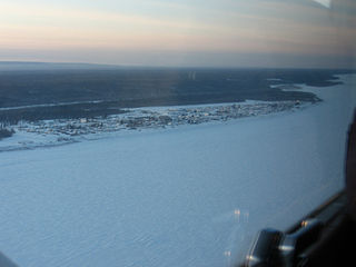
Whatì, officially the Tłı̨chǫ Community Government of Whatì is a First Nations community in the North Slave Region of the Northwest Territories, Canada. Whatì is located by Lac La Martre, about 164 km (102 mi) northwest of the territorial capital of Yellowknife.

Wrigley is a "Designated Authority" in the Dehcho Region of the Northwest Territories, Canada. The Slavey Dene community is located on the east bank of the Mackenzie River, just below its confluence with the Wrigley River and about 466 mi (750 km) northwest of Yellowknife.

Tulita Hamlet in Northwest Territories, Canada

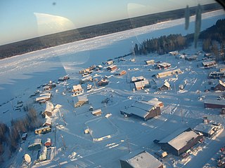
Tulita, which in Slavey means "where the rivers or waters meet," is a hamlet in the Sahtu Region of the Northwest Territories, Canada. It was formerly known as Fort Norman, until 1 January 1996. It is located at the junction of the Great Bear River and the Mackenzie River; the Bear originates at Great Bear Lake adjacent to Deline.

Fort Simpson Village in Northwest Territories, Canada

Fort Simpson is a village, the only one in the entire territory, in the Dehcho Region of the Northwest Territories, Canada. The community is located on an island at the confluence of the Mackenzie and Liard rivers. It is approximately 500 km (310 mi) west of Yellowknife. Both rivers were traditionally trade routes for the Hudson's Bay Company and the native Dene people of the area.

Tsiigehtchic Charter Community in Northwest Territories, Canada

Tsiigehtchic, officially the Charter Community of Tsiigehtchic, is a Gwich'in community located at the confluence of the Mackenzie and the Arctic Red Rivers, in the Inuvik Region of the Northwest Territories, Canada. The community was formerly known as Arctic Red River, until 1 April 1994. The Gwichya Gwich'in First Nation is located in Tsiigehtchic.

Fort Providence Hamlet in Northwest Territories, Canada

Fort Providence is a hamlet in the South Slave Region of the Northwest Territories, Canada. Located west of Great Slave Lake, it has all-weather road connections by way of the Yellowknife Highway branch off the Mackenzie Highway, and the Deh Cho Bridge opened November 30, 2012, near Fort Providence over the Mackenzie. The bridge replaced the ice bridge and ferry, enabling year-round crossing of the river.

Dettah Yellowknives Dene First Nation in Northwest Territories, Canada

Dettah, sometimes, incorrectly, as Detah, is a First Nations community in the North Slave Region of the Northwest Territories, Canada. Located just southeast of the capital of Yellowknife, it is a 6.5 km (4.0 mi) drive from that city by ice road across the north arm of Great Slave Lake in winter or a 27 km (17 mi) drive via the Ingraham Trail, year-round. The name means 'Burnt Point' in the Dogrib language and refers to a traditional fishing camp used by the Dene for hundreds of years.

Norman Wells Town in Northwest Territories, Canada

Norman Wells is a town located in the Sahtu Region, Northwest Territories (NWT), Canada. The town, which hosts the Sahtu Regional office, is situated on the north side of the Mackenzie River and provides a view down the valley of the Franklin and Richardson mountains.

Fort Good Hope Charter Community in Northwest Territories, Canada

Fort Good Hope, is a charter community in the Sahtu Region of the Northwest Territories, Canada. It is located on a peninsula between Jackfish Creek and the east bank of the Mackenzie River, about 145 km (90 mi) northwest of Norman Wells. The two principal languages are North Slavey and English. Hunting and trapping are two major sources of income. The Church of Our Lady of Good Hope, a National Historic Site, is located in the community. The church, completed in 1885, was once home to Father Émile Petitot.

Colville Lake, Northwest Territories Settlement Corporation in Northwest Territories, Canada

Colville Lake is a settlement corporation located in the Sahtu Region of the Northwest Territories, Canada. The community is located 50 km (31 mi) north of the Arctic Circle, on a lake of the same name, and is northeast of Norman Wells. This settlement is the administrative office of the Behdzi Ahda band government. The community is likely named for Hudson's Bay Company Governor Andrew Colvile.

Fort Liard Hamlet in Northwest Territories, Canada

Fort Liard is a hamlet in the Dehcho Region of the Northwest Territories, Canada. It is located 37 km (23 mi) north of the British Columbia border. It became accessible by road in 1984 with the completion of the Liard Highway.

Nahanni Butte Place in Northwest Territories, Canada

Nahanni Butte is a "Designated Authority" in the Dehcho Region of the Northwest Territories, Canada. The community is located at the confluence of the Liard and South Nahanni Rivers in the southwestern part of the NWT.

Jean Marie River Place in Northwest Territories, Canada

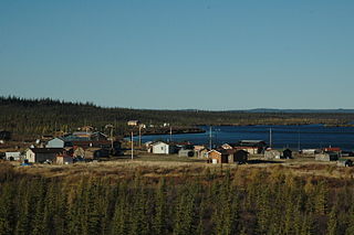
Jean Marie River is a "Designated Authority" in the Dehcho Region of the Northwest Territories, Canada. The community is located on the Jean Marie River where it joins the Mackenzie River. The community has a small airport, Jean Marie River Airport, and is accessible by charter aircraft throughout the year and by the all-season JMR Access Road 27 km (17 mi) from the Mackenzie Highway.

Behchokǫ̀ Tłı̨chǫ Community Government in Northwest Territories, Canada

Behchokǫ̀, officially the Tłı̨chǫ Community Government of Behchokǫ̀, is a community in the North Slave Region of the Northwest Territories, Canada. Behchokǫ̀ is located on the Yellowknife Highway, on the northwest tip of Great Slave Lake, approximately 110 km (68 mi) northwest of Yellowknife.

Łutselke First Nation - Designated Authority of Łutselkʼe in Northwest Territories, Canada

Łutselkʼe, also spelt Łutsel Kʼe, is a "designated authority" in the North Slave Region of the Northwest Territories, Canada. The community is located on the south shore near the eastern end of Great Slave Lake and until 1 July 1992, it was known as Snowdrift, as the community lies near the mouth of the Snowdrift River.

Gamèti Tłı̨chǫ Community Government in Northwest Territories, Canada

Gamètì, officially the Tłı̨chǫ Community Government of Gamètì is a community in the North Slave Region of the Northwest Territories, Canada. Gamètì, according to the Prince of Wales Northern Heritage Centre means "rabbit-net lake". 'Gamè' means 'rabbit', and 'tì' means lake, or water. It is one of the four Tłı̨chǫ communities which form part of the Tlicho Government.

Wekweètì First Nation in Northwest Territories, Canada

Wekweètì, officially the Tłı̨chǫ Community Government of Wekweètì is a community in the North Slave Region of the Northwest Territories, Canada. Wekweètì is a Tłı̨chǫ aboriginal community and is located 195 km (121 mi) north of Yellowknife. It has no year-round road access but does have a winter ice road connection; the majority of transportation to and from the community is through the Wekweètì Airport. Wekweètì is the closest community to the Ekati Diamond Mine on the border with Nunavut. Wekweètì is part of the Tlicho Government.

Kakisa is a "Designated Authority" in the South Slave Region of the Northwest Territories, Canada. The community is located on Kakisa Lake, and is southeast of Fort Providence. Originally located at Tathlina Lake, the community moved, in 1962, to the present location in order to be closer to the Mackenzie Highway and is linked by a 13 km (8.1 mi) all-weather road.

Dehcho Region Administrative region in Northwest Territories, Canada

The Dehcho Region or Deh Cho is one of five administrative regions in the Northwest Territories of Canada. According to Municipal and Community Affairs the region consists of six communities with the regional office situated in Fort Simpson. All communities in the Dehcho are predominantly Dehcho First Nations.

Délı̨nę Charter Community in Northwest Territories, Canada

The Charter Community of Délı̨nę is located in the Sahtu Region of the Northwest Territories, Canada, on the western shore of Great Bear Lake and is 544 km (338 mi) northwest of Yellowknife. Délı̨nę means "where the waters flow", a reference to the headwaters of the Great Bear River, Sahtúdé. It is the only settlement on the shores of Great Bear Lake as Fort Confidence was last used in the 1800s and Port Radium closed in 1982.

References

  1. 1 2 3 4 "Population and dwelling counts, for Canada, provinces and territories, and census subdivisions (municipalities), 2016 and 2011 censuses – 100% data (Northwest Territories)". Statistics Canada. February 8, 2017. Retrieved February 1, 2022.
  2. "NWT Communities - Sambaa-k'e". Government of the Northwest Territories: Department of Municipal and Community Affairs. Retrieved October 29, 2017.
  3. "Northwest Territories Official Community Names and Pronunciation Guide". Prince of Wales Northern Heritage Centre . Yellowknife: Education, Culture and Employment, Government of the Northwest Territories. Archived from the original on January 13, 2016. Retrieved January 13, 2016.
  4. 1 2 Canada Flight Supplement. Effective 0901Z 16 July 2020 to 0901Z 10 September 2020.
  5. 1 2 Trout Lake - Statistical Profile at the GNWT
  6. 1 2 Trout Lake, N.W.T., changes its name to Sambaa K'e
  7. Differences in Community Government Structure
  8. "1981 Census of Canada: Census subdivisions in decreasing population order" (PDF). Statistics Canada. May 1992. Retrieved February 1, 2021.
  9. "1986 Census: Population - Census Divisions and Census Subdivisions" (PDF). Statistics Canada. September 1987. Retrieved February 1, 2022.
  10. "91 Census: Census Divisions and Census Subdivisions - Population and Dwelling Counts" (PDF). Statistics Canada. April 1992. Retrieved February 1, 2022.
  11. "96 Census: A National Overview - Population and Dwelling Counts" (PDF). Statistics Canada. April 1997. Retrieved February 1, 2022.
  12. "Population and Dwelling Counts, for Canada, Provinces and Territories, and Census Subdivisions (Municipalities), 2001 and 1996 Censuses - 100% Data (Northwest Territories)". Statistics Canada. August 15, 2012. Retrieved February 1, 2022.
  13. "Population and dwelling counts, for Canada, provinces and territories, and census subdivisions (municipalities), 2006 and 2001 censuses - 100% data (Northwest Territories)". Statistics Canada. August 20, 2021. Retrieved February 1, 2022.
  14. "Population and dwelling counts, for Canada, provinces and territories, and census subdivisions (municipalities), 2011 and 2006 censuses (Northwest Territories)". Statistics Canada. July 25, 2021. Retrieved February 1, 2022.
  15. 1 2 "Population and dwelling counts: Canada, provinces and territories, and census subdivisions (municipalities), Northwest Territories". Statistics Canada. February 9, 2022. Retrieved February 18, 2022.
  16. Population Estimates By Community from the GNWT
  17. Sambaa K’e Dene Band at the Dehcho First Nations
  18. Trout Lake Infrastructure Profile
  19. Borrow-By-Mail