
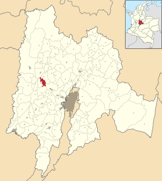
Department of Cundinamarca is one of the departments of Colombia. Its area covers 22,623 square kilometres (8,735 sq mi) and it has a population of 2,919,060 as of 2018. It was created on August 5, 1886, under the constitutional terms presented on the same year. Cundinamarca is located in the center of Colombia.

Tocaima refers to both a city and a municipality in Cundinamarca, Colombia.
Cayetano Heredia University is a private nonprofit university located in Lima, Peru. It was named in honor of Cayetano Heredia, one of the eminent Peruvian physicians of the 19th century. The university is overseen by a board of trustees (patronato) and is not owned by any private or state entity. It is considered one of the top medical schools in Peru, along the Faculty of Medicine "San Fernando" of National University of San Marcos, and is currently one of the major producers and publishers of scientific research in the country.

Liniers is a barrio (neighborhood) of Buenos Aires on the edge of the city, centered on Rivadavia Avenue. It is also an important train station and bus hub, connecting western Gran Buenos Aires with the Buenos Aires Metro.
San Cayetano was a Catholic saint (1480-1547), and may refer to:
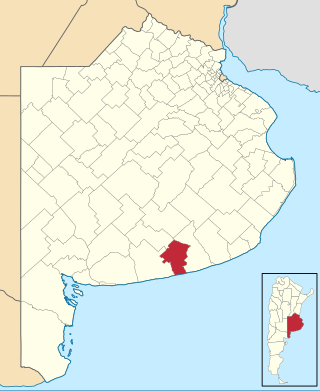
San Cayetano Partido is a partido of Buenos Aires Province in Argentina.

Acacias is a town and municipality in the Meta Department, Colombia. This town is one of the most important municipalities in terms of population and economy, together with La Macarena, Granada and the capital city of Villavicencio. The name of the city is due to the acacia flowers that used to bloom in the region. It is considered one of the municipalities of Meta with more progress and development.

Carmen de Carupa is a municipality and town of Colombia in the Ubaté Province, part of the department of Cundinamarca. The municipality, located in the Ubaté-Chiquinquirá Valley on the Altiplano Cundiboyacense borders San Cayetano in the west, Tausa and Sutatausa in the south, Ubaté and Susa in the east and Simijaca and Buenavista and Coper (Boyacá) in the north.
La Vega is a municipality and town of Colombia in the department of Cundinamarca.

Pacho is a municipality and town of Colombia in the department of Cundinamarca. Pacho is part of the Rionegro Province and the urban centre is situated at a distance of 88 kilometres (55 mi) from the capital Bogotá at an altitude of 2,136 metres (7,008 ft), while the altitude ranges from 1,000 metres (3,300 ft) to 3,700 metres (12,100 ft). The municipality borders San Cayetano, Villagómez and Topaipí in the north, Supatá and Subachoque in the south, Vergara and El Peñón in the west and in the east Zipaquirá, Tausa and Cogua.

San Francisco de Sales, commonly known as San Francisco, is a municipality and town of Colombia in the department of Cundinamarca.

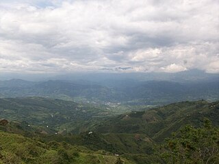
San Juan de Rioseco is a municipality and town of Colombia in the department of Cundinamarca with a population of about 10,000 people. It lies in mountainous terrain in the coffee land at an altitude of about 4,000 feet, high above the Magdalena River, on the western slope of Colombia's eastern cordillera about 60 miles from Bogotá by car. On a clear day the snow-capped peaks of four volcanos in the central cordillera can be seen in the distance to the west.
Tausa is a municipality and town of Colombia in the Ubaté Province, part of the department of Cundinamarca. Tausa is and was an important town on the Altiplano Cundiboyacense due to its salt mine. It was the third most prolific salt deposit for the original inhabitants of the area; the Muisca. Tausa's urban centre is located at an elevation of 2,950 metres (9,680 ft) and a distance of 65 kilometres (40 mi) from the capital Bogotá. The municipality borders San Cayetano, Carmen de Carupa and Sutatausa in the north, Pacho in the west, Sutatausa, Cucunubá and Suesca in the east and in the south with Nemocón and Cogua.
Usme is the 5th locality of the Capital District of Bogotá, capital city of Colombia. Usme is located in the south of Bogotá, bordering to the north the localities of San Cristóbal, Rafael Uribe Uribe and Tunjuelito, to the west the locality of Ciudad Bolívar, to the south the locality of Sumapaz, and to the east, behind the Eastern Hills, the municipalities of Ubaque, Chipaque and Une in the Department of Cundinamarca.
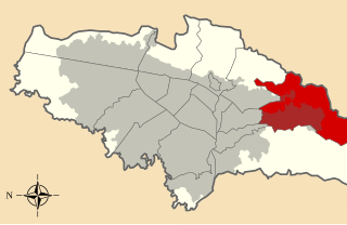
Gualivá Province is one of the 15 provinces in the Cundinamarca Department, Colombia. Gualivá borders the Lower Magdalena Province to the west, to the north the Rionegro Province, to the east and southeast the Western Savanna Province, to the south slightly the Tequendama Province and to the southwest the Central Magdalena Province.
Central Magdalena Province is one of the 15 provinces in the Cundinamarca Department, Colombia. Central Magdalena borders to the west the Tolima Department and the Magdalena River, to the north the Lower Magdalena Province, to the east the Gualivá and Tequendama Provinces and to the south the Upper Magdalena Province.
Albán is a municipality and town of Colombia in the department of Cundinamarca.
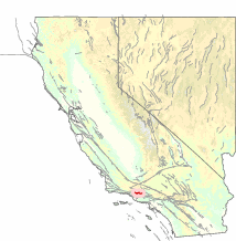
The San Cayetano Fault is an east-west trending thrust fault in Ventura County, Southern California. It stretches for 45 kilometers (28 mi), north of the city of Ventura, near the Topatopa Mountains, Piru, Fillmore, Santa Paula, Sulphur Springs, and Ojai.

Cundinamarca State was one of the states of Colombia. It was created on 15 June 1857 as Estado Federal de Cundinamarca, in 1858 was recognized as Estado de la Federación, and in the constitution of 1863 renamed as Estado Soberano of the United States of Colombia. It was abolished in 1886.


