San Francisco, Old San Juan

Last updated
San Francisco
San Francisco subbarrio, San Juan Antiguo barrio, San Juan, Puerto Rico.jpg
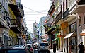
Hill in San Francisco
San Juan Antiguo Sub Barrios.jpg
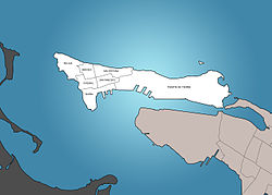
San Francisco is in San Juan Antiguo
San Juan Antiguo.jpg
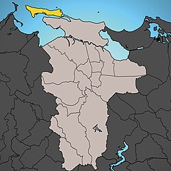
San Juan Antiguo is in San Juan
Caribbean location map.svg
Red pog.svg
San Francisco
San Juan is in Puerto Rico
Coordinates: 18°27′57″N66°06′47″W / 18.4657344°N 66.1131640°W / 18.4657344; -66.1131640 Coordinates: 18°27′57″N66°06′47″W / 18.4657344°N 66.1131640°W / 18.4657344; -66.1131640
Commonwealth Flag of Puerto Rico.svg  Puerto Rico
Municipality Flag of San Juan, Puerto Rico.svg San Juan
Barrio San Juan Antiguo

San Francisco, within Old San Juan, is one of the 7 subbarrios of San Juan Antiguo barrio in the municipality of San Juan in Puerto Rico. [1]

Contents

History

Puerto Rico was ceded by Spain in the aftermath of the Spanish–American War under the terms of the Treaty of Paris of 1898 and became an unincorporated territory of the United States. In 1899, the United States Department of War conducted a census of Puerto Rico finding that the population of San Francisco was 1,177. [2] In 2010, the population of San Francisco was 796. [1] In 2010, the population of Catedral was 588. [1]

Saint Francis of Assisi Church

Parroquia San Francisco de Asis (Saint Francis of Assisi Church) is located on San Francisco Street. This historic church gives its name to the subdistrict. Some famous Puerto Rican figures such as Impressionist painter Francisco Oller have been buried in its crypt.

See also

Related Research Articles

Cupey, San Juan, Puerto Rico Barrio of San Juan, Puerto Rico

Cupey is one of the 18 barrios of the municipality of San Juan, Puerto Rico located in the mountainous area of the municipality. It is the largest barrio or district in the San Juan and the third most populous with 36,659 inhabitants according to Census 2000. The territorial land area of Cupey is 7.49 square miles (19.40 km2). It is bound by the municipality of Caguas to the South, by the municipality of Trujillo Alto to the East, by the barrios of Caimito and Monacillo to the West, and by the barrios of El Cinco and Sabana Llana Sur to the North. Between 1990 and 2000 Cupey had a 17.98% increase in population, more than any other barrio in San Juan.

Pueblo, San Juan, Puerto Rico Barrio of Puerto Rico

Río Piedras Pueblo,, is one of 18 barrios in the municipality of San Juan, Puerto Rico. Rio Piedras Pueblo is what used to be the urban center-barrio of the former municipality of Río Piedras until 1951, when the municipality of Rio Piedras was merged with the municipality of San Juan.

Ballajá, Old San Juan Subbarrio of San Juan Antiguo in Puerto Rico

Ballajá, located in Old San Juan, is one of 7 subbarrios of San Juan Antiguo barrio in the municipality of San Juan in Puerto Rico.

Catedral, Old San Juan Subbarrio of San Juan Antiguo in Puerto Rico

Catedral, located within Old San Juan, is one of 7 subbarrios of San Juan Antiguo barrio in the municipality of San Juan in Puerto Rico.

Mercado, Old San Juan Subbarrio of San Juan Antiguo in Puerto Rico

Mercado, located within Old San Juan, is one of 7 subbarrios in San Juan Antiguo barrio in the municipality of San Juan in Puerto Rico.

San Cristóbal, Old San Juan Subbarrio of San Juan Antiguo in Puerto Rico

San Cristóbal, within Old San Juan, is one of the seven subbarrios of San Juan Antiguo barrio in the municipality of San Juan in Puerto Rico.

Bayamón barrio-pueblo Historical and administrative center (seat) of Bayamón, Puerto Rico

Bayamón barrio-pueblo is a barrio and the administrative center (seat) of Bayamón, a municipality of Puerto Rico. Its population in 2010 was 4,746.

San Juan Antiguo Barrio of San Juan, Puerto Rico

San Juan Antiguo, is a barrio located in the municipality of San Juan in the Commonwealth of Puerto Rico. San Juan Antiguo has 7 subbarrios. In 2010, San Juan Antiguo had a population of 7,085 inhabitants and a population density of 2,681.9 people per km2. San Juan Antiguo is entirely located within the Isleta de San Juan, the islet off the coast of Puerto Rico where Old San Juan was settled, connected to the mainland by bridges and a causeway.

La Torre, Lares, Puerto Rico Barrio of Puerto Rico

La Torre is a barrio in the municipality of Lares, Puerto Rico. Its population in 2010 was 1,574.

Mirasol, Lares, Puerto Rico Barrio of Puerto Rico

Mirasol is a barrio in the municipality of Lares, Puerto Rico. Its population in 2010 was 938.

Comerío barrio-pueblo Historical and administrative center (seat) of Comerío, Puerto Rico

Comerío barrio-pueblo is a barrio and the administrative center (seat) of Comerío, a municipality of Puerto Rico. Its population in 2010 was 3,657.

Yauco barrio-pueblo Historical and administrative center (seat) of Yauco, Puerto Rico

Yauco barrio-pueblo is a barrio and the administrative center (seat) of Yauco, a municipality of Puerto Rico. Its population in 2010 was 3,091.

Arroyo barrio-pueblo Historical and administrative center (seat) of Arroyo, Puerto Rico

Arroyo barrio-pueblo is a barrio and the administrative center (seat) of Arroyo, a municipality of Puerto Rico. Its population in 2010 was 1,206.

Camuy barrio-pueblo Historical and administrative center (seat) of Camuy, Puerto Rico

Camuy barrio-pueblo is a barrio and the administrative center (seat) of Camuy, a municipality of Puerto Rico. Its population in 2010 was 3,354.

Maricao barrio-pueblo Historical and administrative center (seat) of Maricao, Puerto Rico

Maricao barrio-pueblo is a barrio and the administrative center (seat) of Maricao, a municipality of Puerto Rico. Its population in 2010 was 716.

Santa Isabel barrio-pueblo Historical and administrative center (seat) of Santa Isabel, Puerto Rico

Santa Isabel barrio-pueblo is a barrio and the administrative center (seat) of Santa Isabel, a municipality of Puerto Rico. Its population in 2010 was 5,133.

Utuado barrio-pueblo Historical and administrative center (seat) of Utuado, Puerto Rico

Utuado barrio-pueblo is a barrio and the administrative center (seat) of Utuado, a municipality of Puerto Rico. Its population in 2010 was 5,856.

Lares barrio-pueblo Historical and administrative center (seat) of Lares, Puerto Rico

Lares barrio-pueblo is a barrio and the administrative center (seat) of Lares, a municipality of Puerto Rico. Its population in 2010 was 2,690.

Orocovis barrio-pueblo Historical and administrative center (seat) of Orocovis, Puerto Rico

Orocovis barrio-pueblo is a barrio and the administrative center (seat) of Orocovis, a municipality of Puerto Rico. Its population in 2010 was 682.

Las Piedras barrio-pueblo Historical and administrative center (seat) of Las Piedras, Puerto Rico

Las Piedras barrio-pueblo is a barrio and the administrative center (seat) of Las Piedras, a municipality of Puerto Rico. Its population in 2010 was 1,500.

References

  1. 1 2 3 Puerto Rico: 2010 Population and housing unit counts (PDF). U.S. Dept. of Commerce, Economics and Statistics Administration, U.S. Census Bureau. 2010. p. 76.
  2. Joseph Prentiss Sanger; Henry Gannett; Walter Francis Willcox (1900). Informe sobre el censo de Puerto Rico, 1899, United States. War Dept. Porto Rico Census Office (in Spanish). Imprenta del gobierno. p.  162.