
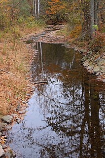
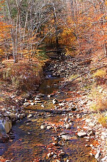
White Deer Hole Creek is a 20.5-mile (33.0 km) tributary of the West Branch Susquehanna River in Clinton, Lycoming and Union counties in the U.S. state of Pennsylvania. A part of the Chesapeake Bay drainage basin, the White Deer Hole Creek watershed drains parts of ten townships. The creek flows east in a valley of the Ridge-and-valley Appalachians, through sandstone, limestone, and shale from the Ordovician, Silurian, and Devonian periods.

White Deer Creek is a tributary of the West Branch Susquehanna River in Centre County and Union County, in Pennsylvania, in the United States. It is approximately 28 miles (45 km) long and flows through Miles Township in Centre County and Hartley Township, Lewis Township, West Buffalo Township, and White Deer Township in Union County. The watershed of the creek has an area of 45.1 square miles (117 km2). Parts of the creek are designated as impaired. The creek's discharge near White Deer can be as low as 3 cubic feet per second (0.085 m3/s) or as high as 169 cubic feet per second (4.8 m3/s).
Wallace Run is a tributary of Bald Eagle Creek in Centre County, Pennsylvania, in the United States. It is 12.1 miles (19.5 km) long and is a low-alkalinity stream. The stream flows through Union Township and Boggs Township in Centre County. Most of the watershed is in Boggs Township. North Branch Wallace Run is one tributary of the stream. The watershed has an area of 24 square miles. Oaks, maples, ash trees, birches, hemlocks, and rhododendrons all exist in the upper reaches of the stream, which is mostly forested. The lower reaches of the stream are mostly developed.

Spruce Run is a tributary of Buffalo Creek in Union County, Pennsylvania, in the United States. It is approximately 14 miles (23 km) long and flows through Hartley Township, Lewis Township, West Buffalo Township, White Deer Township, Buffalo Township, and Kelly Township. The watershed of the stream has an area of 27.2 square miles (70 km2). The stream has two named tributaries: Black Run and Muddy Run. It is not designated as an impaired waterbody, but it is affected by sediment and nutrients.

Rapid Run is a tributary of Buffalo Creek in Centre County and Union County in Pennsylvania, in the United States. It is approximately 14.4 miles (23.2 km) long and flows through Miles Township in Centre County and Hartley Township, Lewis Township, West Buffalo Township, and Buffalo Township in Union County. The watershed of the stream has an area of 18.7 square miles (48 km2). Some streams in the watershed are impacted by nutrients, sediment, E. coli, and thermal radiation and one unnamed tributary is designated as an impaired waterbody. Rapid Run is a freestone mountain stream in the ridge and valley physiographic province. It flows through a lake known as Halfway Lake and also passes through the Rapid Run Gap.

South Run is a tributary of Bowman Creek in Wyoming County, Pennsylvania, in the United States. It is approximately 2.5 miles (4.0 km) long and flows through Monroe Township. The watershed of the stream has an area of 3.42 square miles (8.9 km2). It is not designated as an impaired waterbody. The surficial geology in the vicinity of the stream consists of alluvium, alluvial terrace, and Wisconsinan Till. Its watershed is designated as a High-Quality Coldwater Fishery and a Migratory Fishery.
Beaver Run is a tributary of Bowman Creek in Luzerne County and Wyoming County, in Pennsylvania, in the United States. It is approximately 7.7 miles (12.4 km) long and flows through Lake Township in Luzerne County and Noxen Township in Wyoming County. The watershed of the stream has an area of 10.6 square miles (27 km2). It is not designated as an impaired waterbody. The surficial geology in its vicinity includes alluvial fan, alluvial terrace, alluvium, Wisconsinan Till, Wisconsinan Ice-Contact Stratified Drift, fill, wetlands, and bedrock.
Broad Hollow Run is a tributary of Bowman Creek in Wyoming County, Pennsylvania, in the United States. It is approximately 1.0 mile (1.6 km) long and flows through Noxen Township. The watershed of the stream has an area of 1.04 square miles (2.7 km2). The surficial geology in the vicinity of the stream consists of alluvium, alluvial fan, and Wisconsinan Till. Its watershed is designated as a High-Quality Coldwater Fishery and a Migratory Fishery.
Cider Run is a tributary of Bowman Creek in Wyoming County, Pennsylvania, in the United States. It is approximately 2.5 miles (4.0 km) long and flows through Forkston Township and Noxen Township. The watershed of the stream has an area of 3.77 square miles (9.8 km2). The stream is not designated as an impaired waterbody. Its watershed is classified as Exceptional Value waters and a Migratory Fishery and the stream is designated as a Wilderness Trout Stream.
Dry Run is a tributary of Susquehecka Creek in Snyder County, Pennsylvania, in the United States. It is approximately 2.9 miles (4.7 km) long and flows through Washington Township and Freeburg. The watershed of the stream has an area of 1.83 square miles (4.7 km2). The stream has one unnamed tributary. Both Dry Run and its unnamed tributary are impaired by siltation due to agriculture. Dry Run has been known to experience flooding in Freeburg.
Kern Run is a tributary of Middle Creek in Snyder County, Pennsylvania, in the United States. It is approximately 5.7 miles (9.2 km) long and flows through Spring Township, Beaver Township, and Beavertown. The watershed of the stream has an area of 12.3 square miles (32 km2). The stream has two named tributaries: Luphers Run and Wetzel Run. Kern Run is dammed in one place to produce a 24-acre (9.7 ha) lake for drinking water and flood control. Some reaches of the stream are impaired. A number of bridges have also been constructed across it. The drainage basin of the stream is designated as a Coldwater Fishery and a Migratory Fishery. Wild trout naturally reproduce within it.

Lick Run is a tributary of White Deer Creek in Union County and Lycoming County, in Pennsylvania, in the United States. It is approximately 2.7 miles (4.3 km) long and flows through White Deer Township in Union County and Washington Township in Lycoming County. The watershed of the stream has an area of 2.10 square miles (5.4 km2). The stream has one unnamed tributary. Wild trout naturally reproduce within Lick Run, and beavers began assembling a dam on it at least once.

Mile Run is a tributary of White Deer Creek in Union County, Pennsylvania, in the United States. It is approximately 1.9 miles (3.1 km) long and flows through West Buffalo Township. The watershed of the stream has an area of 1.57 square miles (4.1 km2). It has been described as a "spring run". Wild trout naturally reproduce within the stream and numerous bryophyte species have been observed in its vicinity.
Cowbell Hollow is a tributary of White Deer Creek in Union County, Pennsylvania, in the United States. It is approximately 0.6 miles (0.97 km) long and flows through West Buffalo Township. The watershed of the stream has an area of 0.26 square miles (0.67 km2). The stream is not designated as an impaired waterbody. Wild trout naturally reproduce within it throughout its length.

Spring Run is a tributary of the West Branch Susquehanna River in Northumberland County, Pennsylvania, in the United States. It is approximately 2.3 miles (3.7 km) long and flows through Delaware Township and Watsontown. The watershed of the stream has an area of 1.34 square miles (3.5 km2). The stream is designated as an impaired waterbody due to sedimentation/siltation and unknown causes. The stream is classified as a Warmwater Fishery.
Beartrap Hollow is a tributary of White Deer Hole Creek in Lycoming County, Pennsylvania, in the United States. It is approximately 1.5 miles (2.4 km) long and flows through Washington Township. The watershed of the stream has an area of 0.42 square miles (1.1 km2). The stream is not designated as an impaired waterbody. Much of the stream's length is on South White Deer Ridge and it is near Tiadaghton State Forest.

Spring Creek is a tributary of White Deer Hole Creek in Lycoming County and Union County, in Pennsylvania, in the United States. It is approximately 8.2 miles (13.2 km) long and flows through Washington Township in Lycoming County and Gregg Township in Union County. The watershed of the creek has an area of 21.1 square miles (55 km2). The creek is not designated as an impaired waterbody. The area in its vicinity was settled by 1787 and a mill was constructed on it in 1842. A number of bridges have been constructed over the creek. Its drainage basin is designated as a Trout Stocked Fishery and a Migratory Fishery.

Fidlers Run is a tributary of the Susquehanna River in Northumberland County, Pennsylvania, in the United States. It is approximately 3.1 miles (5.0 km) long and flows through Jackson Township and Lower Mahanoy Township. The watershed of the stream has an area of 6.88 square miles (17.8 km2). The stream is not designated as an impaired waterbody, although a reaches of a few of its unnamed tributaries are. It is a small stream, with a width of 3 to 5 feet. Large areas of agricultural land occur along a substantial portion of its length.
Silver Creek is a tributary of Saucon Creek in Northampton County, Pennsylvania, in the United States. It is approximately 3.2 miles (5.1 km) long and flows through Lower Saucon Township and Hellertown. The watershed of the creek has an area of 2.89 square miles (7.5 km2). The creek is a very small stream that is urban in its lower reaches. However, it is not designated as an impaired waterbody and is inhabited by trout. The creek has been a major source of flooding in Hellertown.
Polk Valley Run is a tributary of Saucon Creek in Northampton County, Pennsylvania. It is approximately 1.9 miles (3.1 km) long and flows through Lower Saucon Township and Hellertown. The watershed of the stream has an area of 2.13 square miles (5.5 km2). A reach of the stream is designated as an impaired waterbody due to siltation from agriculture. However, wild trout and other wildlife are present in and around it. Most of the watershed is forested.


