Sangre de Cristo Ranches, Colorado

Last updated

Sangre de Cristo Ranches, Colorado
Sangre de Cristo Ranches.JPG
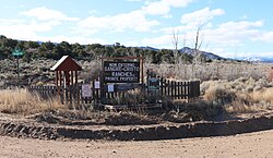
Signs at one of the entrances.
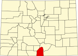
USA Colorado location map.svg
Red pog.svg
Location in the state of Colorado
Usa edcp location map.svg
Red pog.svg
Sangre de Cristo Ranches, Colorado (the United States)
Coordinates: 37°23′21″N105°20′10″W / 37.38917°N 105.33611°W / 37.38917; -105.33611
Country Flag of the United States (23px).png  United States
State Flag of Colorado.svg Colorado
County Costilla County
Time zone UTC-7 (MST)
  Summer (DST) UTC-6 (MDT)
ZIP code [1]
81133 (Fort Garland)

Sangre de Cristo Ranches is an unincorporated community located near Fort Garland in Costilla County, Colorado, United States. The U.S. Post Office at Fort Garland (ZIP Code 81133) serves Sangre de Cristo Ranches postal addresses. [1]

Contents

Geography

Sangre de Cristo Ranches is a private, rural subdivision located in the heart of the Sangre de Cristo Mountain range in Southern Colorado. It can be accessed from Route 160 at the eastern edge of the San Luis Valley, about 50 miles (80 km) west of Walsenburg, 1-mile (1.6 km) east of Fort Garland, and 30 miles (48 km) east of Alamosa. The ranches are located in Costilla County. Forbes, Inc. developed this area and began selling lots in 1971 and finished the sales operation around 2000. There are slightly under 8000 lots ranging in size from 5 to 30 acres (120,000 m2). The subdivision encompasses approximately 56,160 acres (227.3 km2) of land, of which 4,624 acres (18.71 km2) are devoted to Common Land.

See also

References

  1. 1 2 "ZIP Code Lookup" (JavaScript/HTML). United States Postal Service. January 3, 2007. Retrieved January 3, 2007.