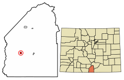
The Capilla de Viejo San Acacio in Viejo San Acacio
San Acacio Mission Church (Capilla de Viejo San Acacio) – Built early in the 1860s, the Mission of San Acacio is the oldest standing church in Colorado. Constructed with 24-inch adobe walls, the mission underwent extensive restoration during the 1990s. In addition to stabilizing the foundation, several wooden columns were added to the interior to take the weight of the roof off the fragile walls. An altar screen, or retablo, was commissioned from Maria Romero Cash, a New Mexican artist specializing in religious folk art.
San Acacio Bank
Old San Acacio Cemetery – In old San Acacio there is a cemetery nicknamed Viejo Cemetery. The cemetery is located in a churchyard in Old San Acacio. The oldest marked grave in the cemetery is from 1907, and the cemetery is currently full.
New San Acacio Cemetery – The new cemetery is located 3/4 mile south of San Acacio. It is a public cemetery, and the oldest marked grave in the cemetery is from 1906. It is currently in use.[7]
This page is based on this Wikipedia article Text is available under the CC BY-SA 4.0 license; additional terms may apply. Images, videos and audio are available under their respective licenses.