Jaroso, Colorado | |
|---|---|
 Jaroso, with Ute Mountain on the left. | |
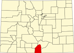
 Jaroso, Colorado Location within the state of Colorado | |
| Coordinates: 37°00′14″N105°37′26″W / 37.00389°N 105.62389°W | |
| Country | |
| State | |
| County | Costilla [1] |
| Elevation | 7,575 ft (2,309 m) |
| Time zone | UTC-7 (MST) |
| • Summer (DST) | UTC-6 (MDT) |
| ZIP code [2] | 81138 |
| GNIS feature ID | 193115 [1] |
Jaroso is an unincorporated community and a U.S. Post Office located in Costilla County, Colorado, United States. The Jaroso Post Office has the ZIP Code 81138. [2]
A post office called Joroso has been in operation since 1911. [3] Jaroso is a name derived from Spanish meaning "willows". [4]