
Formello is a comune (municipality) in the Metropolitan City of Rome Capital. It is located southwest of the Monti Sabatini, within the Regional Park of Veii. The communal territory sits on large deposits of tuff, which is intensively mined in the area.

Monte Soratte is a mountain ridge in the Metropolitan City of Rome, central Italy. It is a narrow, isolated limestone ridge with a length of 5.5 km (3.4 mi) and six peaks. Located some 10 km (6.2 mi) south east of Civita Castellana and c. 45 km (28 mi) north of Rome, it is the sole notable ridge in the Tiber Valley. The nearest settlement is the village of Sant'Oreste. Saint Orestes or Edistus, after whom the settlement is named, is said to have been martyred near Monte Soratte.

Cave is a town and comune in the Latium region of Italy, 42 kilometres (26 mi) southeast of Rome. As of 2011 its population was of 10,421.

Saint-Rhémy-en-Bosses is a village and comune in the Aosta Valley, region in the north-western Italy.
San Genesio ed Uniti is a comune (municipality) in the Province of Pavia in the Italian region Lombardy, located about 25 km south of Milan and about 11 km northeast of Pavia. As of 31 December 2004, it had a population of 3,567 and an area of 9.0 km².
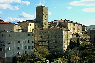
Santa Fiora is a comune (municipality) in the province of Grosseto, in the Italian region of Tuscany, located about 110 kilometres southeast of Florence and about 40 km (25 mi) east of Grosseto. Santa Fiora borders the following municipalities: Abbadia San Salvatore, Arcidosso, Castel del Piano, Castell'Azzara, Piancastagnaio, Roccalbegna, and Semproniano. It is one of I Borghi più belli d'Italia.
Cellere is a comune (municipality) in the Province of Viterbo in the Italian region of Latium, located about 90 kilometres (56 mi) northwest of Rome and about 30 kilometres (19 mi) northwest of Viterbo.

Faleria is a comune (municipality) in the Province of Viterbo in the Italian region of Latium, located about 35 kilometres (22 mi) north of Rome and about 35 kilometres (22 mi) southeast of Viterbo.

Stimigliano is a comune (municipality) in the Province of Rieti in the Italian region of Latium, located about 45 kilometres (28 mi) north of Rome and about 25 kilometres (16 mi) southwest of Rieti. As of 1 January 2018, it had a population of 2,321 and an area of 11.4 square kilometres (4.4 sq mi).

Agosta is a comune (municipality) in the Metropolitan City of Rome in the Italian region of Latium, located about 45 kilometres (28 mi) east of Rome.
Campagnano di Roma is a comune (municipality) in the Metropolitan City of Rome in the Italian region of Latium, located about 30 kilometres northwest of Rome. It was first mentioned in 1076, having been carved out of the great estate assembled on the Roman pattern by Pope Adrian I, ca. 780, his Domusculta Capracorum. In medieval times, Campagnano di Roma was on the via Francigena. Here, Sigeric, Archbishop of Canterbury, sojourned on his return journey from Rome about 990.
Civitella San Paolo is a comune (municipality) in the Metropolitan City of Rome in the Italian region of Lazio, located about 35 kilometres (22 mi) north of Rome.

Colonna is a comune (municipality) in the Metropolitan City of Rome in the Italian region of Latium, located about 20 kilometres (12 mi) southeast of Rome, on the Alban Hills. With a population of some 4,300, it is the smallest of the Castelli Romani.
Gallicano nel Lazio is a comune (municipality) in the Metropolitan City of Rome in the Italian region of Latium, located about 25 kilometres (16 mi) east of Rome at the feet of the Monti Prenestini.

Lanuvio is a comune (municipality) in the Metropolitan City of Rome in the Italian region of Latium, located about 30 kilometres (19 mi) southeast of Rome, on the Alban Hills.
Ponzano Romano is a comune (municipality) in the Metropolitan City of Rome in the Italian region of Latium, located about 40 kilometres (25 mi) north of Rome. As of 31 December 2004, it had a population of 1,061 and an area of 19.3 square kilometres (7.5 sq mi).

Rignano Flaminio is a comune (municipality) in the Metropolitan City of Rome in the Italian region of Latium, about 35 kilometres (22 mi) north of Rome. It is across the Via Flaminia.

Maenza is a comune (municipality) in the Province of Latina in the Italian region Lazio, located about 70 km (43 mi) southeast of Rome and about 25 km (16 mi) east of Latina. It is home to a castle, originally built as a watchtower in the 12th–13th centuries, and enlarged in the 16th century. In an effort to bring in new residents, it is selling abandoned houses for €1 if buyers commit to renovations.
Lierna is a comune in the province of Lecco in Lombardy, in north-west Italy. It lies on the eastern shore of Lake Como, about 60 kilometres (37 mi) north of Milan and about 15 kilometres (9 mi) north-west of Lecco.
Saint Edistus is venerated as a martyr and saint by the Roman Catholic and Eastern Orthodox churches. His legend states that he was martyred on the Via Laurentina and his passio places his martyrdom during the reign of Nero, on October 12, 60 AD.


