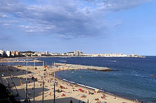
Palamós is a town and municipality in the Mediterranean Costa Brava, located in the comarca of Baix Empordà, in the province of Girona, Catalonia, Spain.
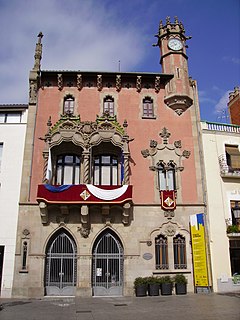
Granollers is a city in central Catalonia, about 30 kilometers northeast of Barcelona. It is the capital and most densely populated city of the comarca of Vallès Oriental.

Sant Llorenç de la Muga is a municipality in the Alt Empordà comarca, in the Province of Girona, Catalonia, Spain with an area of 32.06 km² and a population of 177 people.

Manlleu is municipality in the comarca of Osona, in the province of Barcelona, Catalonia, northern Spain.

Masquefa is a municipality in the comarca of the Anoia in Catalonia, Spain. It is situated on the edge of the Penedès Depression on the road between Piera and Martorell. It is served by a station on the FGC railway line R6 from Barcelona via Martorell to Igualada.

Sant Andreu de la Barca is a municipality in the comarca of the Baix Llobregat in Catalonia, Spain. It is situated on the right bank of the Llobregat river, on the main N-II road The main rail lines of the Llobregat corridor pass through the town, and all the FGC suburban services stop at the station.

Sant Esteve Sesrovires is a municipality in the comarca of the Baix Llobregat in Catalonia, Spain. It is situated on the left bank of the Anoia river, and is served by the FGC railway line R6 from Barcelona and Martorell to Igualada and by the road from Martorell to Capellades.

Cantallops is a municipality in the comarca of the Alt Empordà in Girona, Catalonia, Spain. It is situated below the Albera Range, and is linked to La Jonquera by the GI-601 road.

Riudellots de la Selva is a municipality in the comarca of the Selva in Catalonia, Spain. It is situated in the basin of the Onyar river, on the A-7 autopista and the main N-II road, and is served by a RENFE railway station on the line between Barcelona and Girona and the GE-672 road and is close to the aeroport of Girona.
Olius is a municipality in the comarca of the Solsonès in Catalonia, Spain. It is situated on the Cardener river above the reservoir of Sant Ponç. The village is served by the C-149 road between Solsona and Berga. The church of Sant Esteve d'Olius is a protected historico-artistic monument.

Dosrius is a municipality in the comarca of Maresme in Catalonia, Spain, located in the interior of the comarca on the border with the Eastern Valleys, and is at the head of the Argentona Riera. The original name, first recorded in 963, is "Duos Rios". This literally means "Two Rivers" and refers to the 2 rivers that join to form the Argentona Riera, and is reflected in the coat of arms. These rivers are rarely flowing, though quickly fill during wet weather causing disruption in the village owing to the narrow streets being one way. Newer housing and the school are on the other side of the river, and egress from housing further up the valley frequently takes this route owing to the poor condition of the newly built "Ronda de Dalt". A bridge has been built that would alleviate this problem, though this still hasn't been opened due to the currently suspended construction work that is part of the same development. It is unknown when the bridge will be open to traffic.

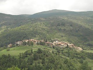
Sant Jaume de Frontanyà is a municipality in the comarca of the Berguedà in Catalonia, Spain. It is situated in the Pyrenees below the peak of Pedró de Tubau (1543 m). The village was the smallest municipality in Catalonia in terms of population but in 2018 lost the title to Gisclareny after the village grew. The monumental Romanesque church of Sant Jaume is a protected historic-artistic monument from the 11th century. The village is served by a local road to Borredà and it is well known for its peace and tranquility.

Darnius is a municipality in the comarca of the Alt Empordà in Girona, Catalonia, Spain. The first document where is related Darnius was dated in 983, and the written name was Darnicibus. Until the beginning of the 20th century, the main economic activity was the manufacturing of the cork.

Sant Esteve de Palautordera is a municipality in the comarca of the Vallès Oriental in Catalonia, Spain. It forms part of the sub-comarca of Baix Montseny.

Llanars is a municipality in the Pyrenean comarca of Ripollès in Girona, Catalonia, Spain. The parish church is a Romanesque church: Sant Esteve de Llanars.
Pardines is a municipality in the comarca of Ripollès, province of Girona, Catalonia, Spain.

Sant Aniol de Finestres is a municipality in the comarca of Garrotxa in Girona, Catalonia, Spain.

Abella de la Conca is a village in the province of Lleida in the county of Pallars Jussà and the autonomous community of Catalonia, Spain. The municipality is situated on the eastern bank of the Tremp Basin. It comprises the high valleys of the Abella River tributary of the Conques river on its right bank and of the Rams River. The valley of the latter is sandwiched between the Boumort and Carreu mountains. In addition to the Tremp Basin, it comprises a section of the Puials River valley. A portion of the village houses are semi-excavated in the rock.

Sant Guim de la Plana is a village in the province of Lleida and autonomous community of Catalonia, Spain.
Sant Esteve may refer to:


