
Talarn is a municipality in the comarca of the Pallars Jussà in Catalonia, Spain. It is situated in the centre of the Tremp basin, on the Noguera Pallaresa river below the Sant Antoni reservoir. It is the site of a hydroelectric power station and of a training school of the Spanish army. The town is served by the C-147 road between Tremp and La Pobla de Segur.

Ponts is a municipality and a town in the comarca of the Noguera in the province of Lleida, Catalonia, Spain. It is situated on the left bank of the Segre river near its confluence with the Llobregós river and at the point where the routes from Calaf and Cervera meet the route from Lleida to La Seu d'Urgell.

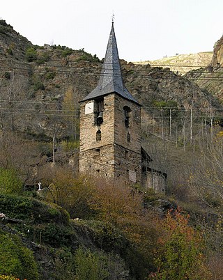
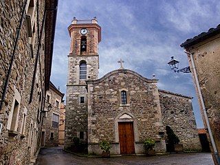
Coll de Nargó is a municipality in the comarca of the Alt Urgell in Catalonia, a region of Spain. It is situated in the Segre valley by the Oliana reservoir. The municipality is served by the C-14 road between Ponts and La Seu d'Urgell, the L-511 road to Isona and the L-401 road to Sant Llorenç de Morunys. The Romanesque church of Sant Climent dates from the eleventh century, and has a rectangular pre-Romanesque bell-tower.
Alt Àneu is a town and municipality in Pallars Sobirà county in Catalonia.
Esterri d'Àneu is a town and municipality in Pallars Sobirà county in Catalonia. In 2022, it had a population of 841.

La Guingueta d'Àneu is a municipality in the comarca of the Pallars Sobirà in Catalonia, Spain. It is situated in the valley of the Noguera Pallaresa river below the reservoir of La Torrassa. It is linked to Sort by the C-147 road.

Alins is a town and municipality in Pallars Sobirà county in Catalonia. It borders Occitania in France and La Massana in Andorra. In 2022, it had a population of 285.

Àger is a municipality in the comarca of the Noguera in Catalonia, Spain. It is situated in the north-west of the comarca, and the territory of the municipality stretches between the Noguera Ribagorçana and Noguera Pallaresa rivers. The Terradets reservoir on the Noguera Pallaresa is situated within the municipality. The village is linked to Balaguer and Tremp by the L-904 road.

Ivars de Noguera is a municipality in the comarca of the Noguera in Catalonia, Spain. It is situated on the left bank of the Noguera Ribagorçana river below the Santa Anna reservoir. The village is served by the L-903 road, which joins the C-148 road to Balaguer.
Camarasa is a municipality in the comarca of the Noguera in Catalonia, Spain. It is situated at the confluence of the Segre and Noguera Pallaresa rivers. The Camarasa reservoir on the Noguera Pallaresa (113 hm³) and the Sant Llorenç de Montgai reservoir on the Segre are important hydroelectric power stations.

Artesa de Segre is a municipality in the comarca of the Noguera in Catalonia, Spain. It is situated in the valley of the Segre river, between Ponts and Balaguer. The municipal territory extends as far as the confluence of the Segre with the Boix. The Urgell canal runs through the municipality to the south of the Segre. The municipality is served by the C-1313 road between Balaguer and Ponts, and is linked to Agramunt by the L-302 road.
Vilanova de la Barca is a municipality in the comarca of Segrià in Catalonia, Spain. It is situated at the confluence of the Segre and Corb rivers. The Urgell canal provides irrigation water for growing cereals and forage plants. The municipality is linked to Lleida and Balaguer by the C-1313 road and a FGC railroad.

Corbins is a municipality in the comarca of the Segrià in Catalonia, Spain. It is situated at the confluence of the Segre and Noguera Ribagorçana rivers and is linked to Lleida by a local road running parallel to the Segre.

Seròs is a municipality in the comarca of the Segrià in Catalonia, Spain. It is situated on the right bank of the Segre river in the south-west of the comarca. The Aragon and Catalonia canal provides irrigation water for growing fruit. The municipality is linked to the rest of the comarca and to Fraga by the C-242 road.

Alfarràs is a municipality in the comarca of the Segrià in Catalonia, Spain. It is situated on the right bank of the Noguera Ribagorçana river, and receives irrigation water from the Aragon and Catalonia canal. The town is served by the N-230 road between Balaguer and Binéfar.

×

Fogars de la Selva is a municipality in the comarca of the Selva in Catalonia, Spain. It is situated to the north of the Montnegre range, and is linked to Tordera by a local road. The village used to be called Fogars de Tordera, and is the only municipality in the Selva to be part of the province of Barcelona rather than the province of Girona.
Collsuspina is a municipality in the comarca of Moianès in Catalonia, Spain. Until May 2015 it was part of Osona.
Bellcaire d'Urgell is a municipality in the comarca of the Noguera in Catalonia, Spain.

Castelló de Farfanya is a municipality in the comarca of the Noguera in Catalonia, Spain.


