Santiago Peak

Last updated
Santiago Peak
Kalawpa, Mount Downey, Old Saddle Buck, Old Saddleback, Saddleback Mountain, San Juan Mountain, Santa Ana Peak, Temescal Peak, Trabuco Peak [1]
Santiago south.jpg
The southern slopes of Santiago Peak, as seen from above San Juan Canyon (February 2008)
Highest point
Elevation 5,689 ft (1,734 m)  NAVD 88 [2]
Prominence 4,387 ft (1,337 m) [3]
Listing California county high points 37th
Coordinates 33°42′38″N117°32′03″W / 33.710513139°N 117.534218203°W / 33.710513139; -117.534218203 [2]
Naming
English translation Saint James
Language of name Spanish
Geography
Relief map of California.png
Red triangle with thick white border.svg
Santiago Peak
Location in California
Usa edcp relief location map.png
Red triangle with thick white border.svg
Santiago Peak
Santiago Peak (the United States)
Location Cleveland National Forest, Orange / Riverside counties, California, U.S.
Parent range Santa Ana Mountains
Topo map USGS Santiago Peak [1]
Climbing
Easiest route Hiking trail

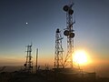
Santiago Peak is the southern mountain of the Saddleback landform in Orange County and Riverside County, California. It is the highest and most prominent peak of both the Santa Ana Mountains and Orange County. The peak is named for Santiago Creek, which begins on its southwestern slope. [1] During most winters, snow falls at least once on the peak. A telecommunication antenna farm with microwave antennas sits atop the peak.

Contents

The Acjachemen referred to the peak as Kalawpa, with the nearby village of Alume meaning "to raise the head in looking upward," in reference to the mountain. [4]

Hiking

The Trail to Holy Jim Falls Photo of the path to Holy Jim Falls.jpg
The Trail to Holy Jim Falls

More than one trail leads to the top of Santiago Peak, but the most popular among hikers is the Holy Jim trail. The Holy Jim trail gains about 4,000 feet (1,200 m) in elevation and is a 16-mile (26 km) round trip. It is a moderate to strenuous hike and is most enjoyable during spring and winter due to the large number of insects during warmer times of the year.

From the summit of Santiago Peak, one can see the larger Southern California peaks like San Gorgonio Mountain, San Jacinto Peak, and Mount San Antonio. However, due to the large number of antennas at the top of Santiago Peak, a full 360-degree view of the surrounding landscapes is not possible. Those at the top must walk approximately a quarter-mile around the perimeter of all the antennas to take in views of every direction.

Radio communication facilities

Santiago Peak is a radio site with buildings owned by American Tower, Crown Castle, MobileRelay Associates, Day Wireless, Orange County Communications, the United States Federal Government, the State of California, and Southern California Edison, among others.[ citation needed ]

Santiago Peak provides radio coverage over much of Los Angeles, Orange, San Bernardino, Riverside, and San Diego counties. It houses both broadcast and two-way communications facilities on virtually every frequency band, including FM broadcast, VHF low- and high-band, UHF, 800/900 MHz, and microwave.[ citation needed ]

In September 2024, the Airport Fire, which originated in Trabuco Canyon, burned to Santiago Peak and damaged parts of the radio infrastructure. [5]

See also

Related Research Articles

<span class="mw-page-title-main">Southern California</span> American geographic and cultural region

Southern California is a geographic and cultural region that generally comprises the southern portion of the U.S. state of California. It includes the Los Angeles metropolitan area as well as the Inland Empire. The region generally contains ten of California's 58 counties: Los Angeles, San Diego, Orange, Riverside, San Bernardino, Kern, Ventura, Santa Barbara, San Luis Obispo, and Imperial counties.

<span class="mw-page-title-main">Santa Ana, California</span> City in California, United States

Santa Ana is a city in and the county seat of Orange County, California, United States. Located in the Greater Los Angeles region of Southern California, the city's population was 310,227 at the 2020 census. As of 2023, Santa Ana is the third most populous city in Orange County, the 14th-most populous city in California, and the 65th most populous city in the United States. Santa Ana is a major regional economic and cultural hub for the Orange Coast.

<span class="mw-page-title-main">Greater Los Angeles</span> Metropolitan area in California, US

Greater Los Angeles is the most populous metropolitan area in the U.S. state of California, encompassing five counties in Southern California extending from Ventura County in the west to San Bernardino County and Riverside County in the east, with the City of Los Angeles and Los Angeles County at its center, and Orange County to the southeast. The Los Angeles–Anaheim–Riverside combined statistical area (CSA) covers 33,954 square miles (87,940 km2), making it the largest metropolitan region in the United States by land area. The contiguous urban area is 2,281 square miles (5,910 km2), whereas the remainder mostly consists of mountain and desert areas. With an estimated population of over 18.3 million, it is the second-largest metropolitan area in the country, behind New York, as well as one of the largest megacities in the world.

<span class="mw-page-title-main">San Jacinto Peak</span> Mountain in California

San Jacinto Peak is a 10,834 ft (3,302 m) peak in the San Jacinto Mountains, in Riverside County, California. Lying within Mount San Jacinto State Park it is the highest both in the range and the county, and serves as the southern border of the San Gorgonio Pass. Naturalist John Muir wrote of San Jacinto Peak, "The view from San Jacinto is the most sublime spectacle to be found anywhere on this earth!"

<span class="mw-page-title-main">Santa Ana River</span> River in California, United States

The Santa Ana River is the largest river entirely within Southern California in the United States. It rises in the San Bernardino Mountains and flows for most of its length through San Bernardino and Riverside counties, before cutting through the northern Santa Ana Mountains via Santa Ana Canyon and flowing southwest through urban Orange County to drain into the Pacific Ocean. The Santa Ana River is 96 miles (154 km) long, and its drainage basin is 2,650 square miles (6,900 km2) in size.

<span class="mw-page-title-main">San Gorgonio Mountain</span> Highest peak of the Transverse Ranges of California, United States

San Gorgonio Mountain, also known locally as Mount San Gorgonio, or Old Greyback, is the highest peak in Southern California and the Transverse Ranges at 11,503 feet (3,506 m).

<span class="mw-page-title-main">Santa Ana Mountains</span> Mountain range in California, United States

The Santa Ana Mountains are a short peninsular mountain range along the coast of Southern California in the United States. They extend for approximately 61 miles (98 km) southeast of the Los Angeles Basin largely along the border between Orange and Riverside counties.

<span class="mw-page-title-main">Palomar Mountain</span> Mountain in San Diego County, California, United States

Palomar Mountain is a mountain ridge in the Peninsular Ranges in northern San Diego County, California. It is known as the location of Palomar Observatory and Hale Telescope, and known for Palomar Mountain State Park.

<span class="mw-page-title-main">Mount Wilson (California)</span> Mountain in California, United States

Mount Wilson is a peak in the San Gabriel Mountains, located within the San Gabriel Mountains National Monument and Angeles National Forest in Los Angeles County, California. With only minor topographical prominence the peak is not naturally noticeable from a distance, although it is easily identifiable due to the large number of antennas near its summit. It is a subsidiary peak of nearby San Gabriel Peak.

<span class="mw-page-title-main">Cleveland National Forest</span> Southernmost National forest of California

The Cleveland National Forest is a U.S. National Forest in Southern California that encompasses 460,000 acres/720 sq mi (1,900 km2) of inland montane regions. It is approximately 60 miles from the Pacific Ocean, within the counties of San Diego, Riverside, and Orange. The landscape varies somewhat, with mostly chaparral canyons, arroyos and high desert, but dotted with meadows and oak and conifer forests. Near water sources, riparian environments and perennial aquatic plants attract native and migratory wildlife, such as at San Diego’s man-made Lake Cuyamaca. A generally warm and dry, inland-Mediterranean climate prevails over the forest, with the cooler months producing morning frost and snowfall. It is the southernmost U.S. National Forest of California. The area is administered by the U.S. Forest Service, a government agency within the United States Department of Agriculture, and is locally overseen by the Descanso, Palomar and Trabuco Ranger Districts.

<span class="mw-page-title-main">Saddleback (Orange County, California)</span>

Saddleback, sometimes called Old Saddleback or Saddleback Mountain, is a natural landmark formed by the two highest peaks of the Santa Ana Mountains in the U.S. state of California, and the gap between them. Resembling a saddle as viewed from most of Orange County, California, this landform dominates the county's eastern skyline. On the clearest days, Saddleback is visible from most of the Greater Los Angeles area.

<span class="mw-page-title-main">San Bernardino Valley</span> Valley in California, United States

The San Bernardino Valley is a valley in Southern California located at the south base of the Transverse Ranges. It is bordered on the north by the eastern San Gabriel Mountains and the San Bernardino Mountains; on the east by the San Jacinto Mountains; on the south by the Temescal Mountains and Santa Ana Mountains; and on the west by the Pomona Valley. Elevation varies from 590 feet (180 m) on valley floors near Chino to 1,380 feet (420 m) near San Bernardino and Redlands. The valley floor is home to over 80% of the more than 4 million people in the Inland Empire region.

<span class="mw-page-title-main">Modjeska Peak</span> Peak in the Santa Ana mountain range

Modjeska Peak is the northern mountain of the Saddleback landform in Orange County California. It is the second-highest peak of the Santa Ana Mountains, after Santiago Peak, whose summit is less than 0.6 mi (0.97 km) to the northwest. Modjeska lies within Cleveland National Forest and, despite being shorter than Santiago, has a smaller peak without manmade structures to obstruct views of the Pacific Ocean and San Gabriel Mountains.

<span class="mw-page-title-main">Mount Rubidoux</span> Mountain in Riverside, California, United States

Mount Rubidoux is a mountain just west of downtown in the city of Riverside, California, United States, that has been designated a city park and landmark. The mountain was once a popular Southern California tourist destination and is still the site of the oldest outdoor non-denominational Easter Sunrise service in the United States. Many historic markers and memorials have been placed on the mountain, the most prominent being the cross at the summit dedicated to Father Junípero Serra. A majority of Mt. Rubidoux is owned by the City of Riverside, while 0.43 acres at the peak is owned by Rivers & Lands Conservancy after the cross attracted a potential lawsuit and the city decided to sell it at auction it to a private organization.

Santiago Canyon is a canyon and unincorporated community in South Orange County, California. According to the 2000 census, Santiago Canyon has several hundred residents living within its borders. Trabuco Canyon, Silverado Canyon, Modjeska Canyon and Williams Canyon are tributaries of Santiago Canyon. Santiago Creek flows northwest from the canyon, then west into the Santa Ana River. Neighborhoods in Santiago Canyon include Santiago Canyon Estates and Falcon View Estates. The landmark Cook's Corner motorcycle restaurant is also located within Santiago Canyon.

<span class="mw-page-title-main">Santiago Creek</span> River in California, United States

Santiago Creek is a major watercourse in Orange County in the U.S. state of California. About 34 miles (55 km) long, it drains most of the northern Santa Ana Mountains and is a tributary to the Santa Ana River. It is one of the longest watercourses entirely within the county. The creek shares its name with Santiago Peak, at 5,687 ft (1,733 m) the highest point in Orange County, on whose slopes its headwaters rise.

<span class="mw-page-title-main">Redonda Mesa</span> Mesa type formation in the American state of California

Redonda Mesa is a mesa type formation located in the southern Santa Ana Mountains, near the Pacific Ocean in Southern California. It is located in an unincorporated area of southwestern Riverside County.

<span class="mw-page-title-main">Mount Lukens</span> Mountain in southern California, United States

Mount Lukens is a mountain peak of the San Gabriel Mountains, in Los Angeles County, Southern California. It is the highest point in the city of Los Angeles.

<span class="mw-page-title-main">Trabuco Peak</span> Stream in the American state of California

Trabuco Peak is a 4,607-foot (1,404 m) summit in the Santa Ana Mountains on the border of Orange and Riverside Counties, California, about halfway between Rancho Santa Margarita and Lake Elsinore. The mountain sits on the divide between Arroyo Trabuco on the west and the Temescal Creek valley on the east. Situated in the Cleveland National Forest, it is the highest summit in the Santa Anas south of Santiago Peak.

References

  1. 1 2 3 "Santiago Peak". Geographic Names Information System . United States Geological Survey, United States Department of the Interior . Retrieved 2009-09-12.
  2. 1 2 "RP 1". NGS Data Sheet. National Geodetic Survey, National Oceanic and Atmospheric Administration, United States Department of Commerce . Retrieved 2009-07-14.
  3. "Santiago Peak, California". Peakbagger.com. Retrieved 2009-07-14.
  4. O'Neil, Stephen; Evans, Nancy H. (1980). "Notes on Historical Juaneno Villages and Geographical Features". UC Merced Journal of California and Great Basin Anthropology. 2 (2): 226–232.
  5. Barragan, Sydney (September 11, 2024). "Flames from Airport fire damage communication towers atop Santiago Peak". The Orange County Register. Southern California News Group. Retrieved September 13, 2024.