
Adamawa State is a state in the North-East geopolitical zone of Nigeria, bordered by Borno to the northwest, Gombe to the west, and Taraba to the southwest while its eastern border forms part of the national border with Cameroon. It takes its name from the historic emirate of Adamawa, with the emirate's old capital of Yola serving as the capital city of Adamawa State. The state was formed in 1991 when the former Gongola State was broken up into Adamawa and Taraba states. The state is one of the most heterogeneous in Nigeria, having over 100 indigenous ethnic groups.

Southern Bantoid is a branch of the Bantoid language family. It consists of the Bantu languages along with several small branches and isolates of eastern Nigeria and west-central Cameroon. Since the Bantu languages are spoken across most of Sub-Saharan Africa, Southern Bantoid comprises 643 languages as counted by Ethnologue, though many of these are mutually intelligible.
Tiv is a Tivoid language spoken in some states in North Central Nigeria, with some speakers in Cameroon. It had over 5.2 million speakers in 2024. The largest population of Tiv speakers are found in Benue state in Nigeria. The language is also widely spoken in some Nigerian states namely, Plateau, Taraba, Nasarawa, Cross River, Adamawa, Kaduna, and Abuja. It is by far the largest of the Tivoid languages, a group of languages belonging to the Southern Bantoid languages.
Taraba is a state in north-eastern Nigeria, named after the Taraba River, which traverses the southern part of the state. It is known as "Nature's Gift to the Nation". Its capital is Jalingo. The state's main ethnic groups are the Fulani, Mumuye, Mambilla, Jukun, Kuteb, Karimjo Wurkun, Tiv, Yandang, Ndola, Ichen, Jenjo, Tigon, and Jibu. The northern part is mainly dominated by the Fulani, Wurkun and Mumuye. The southern part is dominated by the Jukun, Tiv, Chamba, Kuteb and Ichen. The central region is mainly occupied by the Fulani, Mambilla, Ndola, Tigon, Jibu, Wurbo, and Daka people. There are about 80 distinct ethnic groups and their languages in the state.

The Tivoid languages are a branch of the Southern Bantoid languages spoken in parts of Nigeria and Cameroon. The subfamily takes its name after Tiv, the most spoken language in the group.

Chappal Waddi is located in Nigeria and, at 2,419 m (7,936 ft), is the country's highest point. This peak, whose original and indigenous name is "Gang Peak" is steeped in enthralling ancient Mambilla mythologies. It represents the heaquarters of some ancient mythological organizations. It is located in Taraba State, near the border with Cameroon, on the edge of the Gashaka Gumti Forest Reserve and the Gashaka-Gumti National Park on the Mambilla Plateau. It is a part of the Bamenda-Alantika-Mandara Mountain chain of Nigeria and Cameroon. According to local Mambilla legends, good fotunes or bad poor harvests in the agricultural cycles of the Mambilla Plateau were determined at Gang Mountain.
The Mambilla or Mambila people of Nigeria live on the Mambilla Plateau. A small fraction of Mambilla migrants left the Mambilla Plateau for the Ndòm Plain on the Cameroon side of the international border as well as in a couple of small villages, such as New Nàmba, on the Gashaka Plain in the north, and Jiini-Nyalang-Langa area close to the Kwanja. The Mambilla also occupy the Nyorrong-Lii-Ngùum area of Cameroon and are traceable in history to the Bang District of Mambilla Plateau. Today, the preferred ethnonym is spelt Mambila in Cameroon and Mambilla in Nigeria. "Norr" is also used.

The Beboid languages are any of several groups of languages spoken principally in southwest Cameroon, although two languages are spoken over the border in Nigeria. They are probably not most closely related to each other. The Eastern Beboid languages may be most closely related to the Tivoid and Momo groups, though some of the geographical Western Beboid grouping may be closer to Ekoid and Bantu.
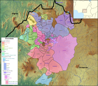
The Grassfields languages are a branch of the Southern Bantoid languages spoken in the Western High Plateau of Cameroon and some parts of Taraba state, Nigeria. Better known Grassfields languages include the Eastern Grassfields languages, Bamun, Yamba, Bali, and Bafut and the Ring languages, Kom, Nso, and Oku. Almost all of these languages are closely related, sharing approximately half of their vocabulary.
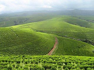
Dorofi is a small town on the Mambilla Plateau in Taraba State in Central Eastern part of Nigeria. It is 40 km from Gembu, the Sardauna Local Government Area headquarters. It is located on Nigeria's border with Cameroon Republic. It has a temperate climate, with a mean air temperature of 17.5 °C (63.5 °F). It is among the coldest towns in Nigeria. Dorofi's landscape consists of hills and valleys. The people of Dorofi engage in small-scale farming down the hills and cattle grazing up the hills. Views from different sites of Dorofi show plantations of eucalyptus, used for building materials as well as a source of energy for domestic work and warming in cold winters.
Takum is a Local Government Area of Taraba State, Nigeria. Its headquarters is the town of Takum, it was created out of Wukari local government in June 1976. Takum borders the Republic of Cameroon in the south, Ussa Local Government to the west, Donga Local Government to the north, District within Takum are Angwan Dutse, Angwa Abuja, Tikari, Fadama, Gahwetun, Akenten, Acha Nyim, Chanchanji (Peva), Sufa, Shimta, Kufi, Muji, Akenten, Lufu, Kashimbilla, Kpaasan, Likam, Bete, Malumshe, Jidu, Tampwa, Dumse, Nyayirim, Barki Lissa, Acha Sarka, Sabon Gida Yukuben etc.
Kurmi is a Local Government Area in Taraba State, Nigeria. As a local government area it is administered by a Local Government Council consisting of a chairman, and elected councillors. The LGA is further divided into wards. Its headquarters are in the town of Ba'Issa.
Gashaka is a Local Government Area in Taraba State, Nigeria. Its headquarters are in the town of Serti.

The Donga River is a river in Nigeria and Cameroon. The river arises from the Mambilla Plateau in Eastern Nigeria, forms part of the international border between Nigeria and Cameroon, and flows northwest to eventually merge with the Benue River in Nigeria. The Donga watershed is 20,000 square kilometres (7,700 sq mi) in area. At its peak, near the Benue the river delivers 1,800 cubic metres (64,000 cu ft) of water per second.

The Mambilla Plateau is a plateau in the Taraba State of Nigeria. The Mambilla Plateau has an average elevation of about 1,600 metres (5,249 ft) above sea level, making it the highest plateau in Nigeria. Some of its villages are situated on hills that are at least 1,828 metres (5,997 ft) above sea level. Some mountains on the plateau and around it are over 2,000 metres (6,562 ft) high, like Gang or Chappal Waddi which has a height of 2,419 metres (7,936 ft) above sea level. It is the highest mountain in Nigeria and in West Africa. The Mambilla Plateau measures about 96 km (60 mi) along its curved length; it is 40 km (25 mi) wide and is bounded by an escarpment that is about 900 m (2,953 ft) high in some places. The plateau covers an area of over 9,389 square kilometres (3,625 sq mi).
The Ngel Nyaki Forest Reserve, whose site is historically known as Majang, is situated on the Mambilla Plateau in North East Nigeria, covering 46 km2. It can be reached on foot from Yelwa village past the Mayo Jigawal, from where it is less than half an hour’s walk to the upper edge of the forest. The elevation ranges from 1,400 metres (4,593 ft) to 1,600 metres (5,249 ft). Ngel Nyaki was formally gazetted a local authority Forest Reserve under Gashaka - Mambilla Native Authority Forest order of April 1969, but presently it is under the management of the Taraba State Government and the Nigerian Conservation Foundation (NCF), with the Nigerian Montane Forest Project (NMFP) as a project partner.

Gembu is a town on the Mambilla Plateau in Taraba State of Nigeria. It is the headquarters of Sardauna Local Government Area in Taraba State.
Nguroje is a town found on the Mambilla Plateau, in Sardauna Local Government Area of Taraba State in eastern Nigeria.
Buru and Angwe constitute a potentially rather divergent Southern Bantoid language spoken in Sardauna LGA, Taraba State of Nigeria.
Ndola People are found in Taraba, Nigeria and located in Kurmi and Ngada. Few are also found in Cameroon.


