Sawyer, Oklahoma

Last updated

Sawyer, Oklahoma
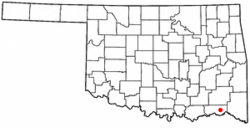
OKMap-doton-Sawyer.PNG
Location of Sawyer, Oklahoma
Coordinates: 34°01′37″N95°22′40″W / 34.02694°N 95.37778°W / 34.02694; -95.37778
Country United States
State Oklahoma
County Choctaw
Area
[1]
  Total8.66 sq mi (22.43 km2)
  Land8.57 sq mi (22.20 km2)
  Water0.09 sq mi (0.23 km2)
Elevation
[2]
440 ft (130 m)
Population
 (2020)
  Total340
  Density39.66/sq mi (15.31/km2)
Time zone UTC-6 (Central (CST))
  Summer (DST) UTC-5 (CDT)
ZIP code
74756
Area code 580
FIPS code 40-65650 [3]
GNIS feature ID2413264 [2]

Sawyer is a town in Choctaw County, Oklahoma, United States. The population was 321 at the 2010 census. [4]

Contents

History

Sawyer was located in Kiamitia County, one of the constituent counties comprising the Apukshunnubbee District of the Choctaw Nation. [5] On November 4, 2022, a violent EF4 tornado passed just east of Sawyer.

Geography

Sawyer is located in eastern Choctaw County at 34°0′46″N95°22′20″W / 34.01278°N 95.37222°W / 34.01278; -95.37222 (34.012880, -95.372138). [6] The town center is on the east side of the Kiamichi River at Hugo Dam. The town limits extend north up the east side of Hugo Lake and west to touch the southwest side of the lake.

U.S. Route 70 passes through the town, leading west 8 miles (13 km) to the city of Hugo, the Choctaw County seat, and east 6 miles (10 km) to Fort Towson.

According to the United States Census Bureau, the town of Sawyer has a total area of 8.8 square miles (22.7 km2), of which 8.6 square miles (22.4 km2) is land and 0.12 square miles (0.3 km2), or 1.13%, is water. [4]

Demographics

Historical population
CensusPop.Note
2000 274
2010 32117.2%
2020 3405.9%
U.S. Decennial Census [7]

As of the census [3] of 2000, there were 274 people, 115 households, and 80 families residing in the town. The population density was 59.0 inhabitants per square mile (22.8/km2). There were 127 housing units at an average density of 27.4 per square mile (10.6/km2). The racial makeup of the town was 76.28% White, 0.36% African American, 17.15% Native American, 0.73% from other races, and 5.47% from two or more races. Hispanic or Latino of any race were 1.46% of the population.

There were 115 households, out of which 27.0% had children under the age of 18 living with them, 61.7% were married couples living together, 6.1% had a female householder with no husband present, and 29.6% were non-families. 25.2% of all households were made up of individuals, and 7.8% had someone living alone who was 65 years of age or older. The average household size was 2.38 and the average family size was 2.89.

In the town, the population was spread out, with 24.8% under the age of 18, 5.1% from 18 to 24, 29.6% from 25 to 44, 27.4% from 45 to 64, and 13.1% who were 65 years of age or older. The median age was 39 years. For every 100 females, there were 97.1 males. For every 100 females age 18 and over, there were 100.0 males.

The median income for a household in the town was $24,375, and the median income for a family was $29,688. Males had a median income of $26,071 versus $19,375 for females. The per capita income for the town was $11,874. About 16.0% of families and 24.9% of the population were below the poverty line, including 24.7% of those under the age of eighteen and 60.9% of those 65 or over.

Related Research Articles

<span class="mw-page-title-main">Choctaw County, Oklahoma</span> County in Oklahoma, United States

Choctaw County is a county located in the U.S. state of Oklahoma. As of the 2020 census, the population was 14,204. Its county seat is Hugo.

<span class="mw-page-title-main">Caney, Oklahoma</span> Town in Oklahoma, United States

Caney is a town in Atoka County, Oklahoma, United States. The population was 205 at the 2010 census.

<span class="mw-page-title-main">Tushka, Oklahoma</span> Town in Oklahoma, United States

Tushka is a town in Atoka County, Oklahoma, United States. The population was 312 at the 2010 census, a decline of 9.6 percent from the figure of 345 recorded in 2000.

<span class="mw-page-title-main">Bennington, Oklahoma</span> Incorporated Town in Oklahoma, United States

Bennington is an incorporated town in Bryan County, Oklahoma, United States. The population was 334 at the 2010 census.

<span class="mw-page-title-main">Bokchito, Oklahoma</span> Town in Oklahoma, United States

Bokchito is a town in Bryan County, Oklahoma, United States. The population was 632 at the 2010 census, an increase of 12.1 percent over the figure of 564 recorded in 2000. In the Choctaw language, "bok" means river, and "chito" means big or large, literally translating into "big creek".

<span class="mw-page-title-main">Caddo, Oklahoma</span> Town in Oklahoma, United States

Caddo is a town in Bryan County, Oklahoma, United States. The population was 997 at the 2010 census, a 5.6 percent gain over the figure of 944 recorded in 2000. The name is derived from a Caddo word, ka do hada’ cho, meaning "real chief" in English. According to Encyclopedia of Oklahoma History and Culture, the town was named for the nearby Caddo Hills.

<span class="mw-page-title-main">Boswell, Oklahoma</span> Town in Oklahoma, United States

Boswell is a town in Choctaw County, Oklahoma, United States. The population was 709 at the 2010 census.

<span class="mw-page-title-main">Fort Towson, Oklahoma</span> Town in Oklahoma, United States

Fort Towson is a town in Choctaw County, Oklahoma, United States. The population was 510 at the 2010 census, a 15.1 percent decline from the figure of 611 recorded in 2000. It was named for nearby Fort Towson, which had been established in May 1824 and named for General Nathan Towson, a hero of the War of 1812. The town of Fort Towson was established in 1902, after the Arkansas and Choctaw Railway reached eastern Choctaw County.

<span class="mw-page-title-main">Soper, Oklahoma</span> Town in Oklahoma, United States

Soper is a town in Choctaw County, Oklahoma, United States. The population was 261 at the 2010 census. The town was named for Pliny L. Soper, who was an attorney for the Arkansas and Choctaw Railway.

Kinta is a town in Haskell County, Oklahoma, United States. The population was 297 at the 2010 census, an increase of 22.2 percent over the figure of 243 recorded in 2000.

<span class="mw-page-title-main">Red Oak, Oklahoma</span> Town in Oklahoma, United States

Red Oak is a town in Latimer County, Oklahoma, United States. The population was 537 at the 2020 Census.

<span class="mw-page-title-main">Wilburton, Oklahoma</span> City in Oklahoma, United States

Wilburton is a city in Latimer County, Oklahoma, United States. It is the county seat of Latimer County. The city had a population of 2,285 as of the 2020 Census. Robbers Cave State Park is 5 miles (8.0 km) north of Wilburton.

<span class="mw-page-title-main">Cowlington, Oklahoma</span> Town in Oklahoma, United States

Cowlington is a town in LeFlore County, Oklahoma. It is part of the Fort Smith metropolitan area. The population was 155 at the time of the 2010 census, a gain of 16.5 percent over the figure of 133 recorded in 2000.

<span class="mw-page-title-main">Pocola, Oklahoma</span> Town in Oklahoma, United States

Pocola is a town in Le Flore County, Oklahoma, United States. It is part of the Fort Smith, Arkansas-Oklahoma metropolitan area. The population was 4,056 in 2010, a gain of 1.6 percent over the figure of 3,994 recorded in 2000. Pocola is a Choctaw word meaning "ten", the approximate distance in miles from Fort Smith, Arkansas.

<span class="mw-page-title-main">Canadian, Oklahoma</span> Town in Oklahoma, United States

Canadian is a town in Pittsburg County, Oklahoma, United States. The population was 239 at the 2000 census.

<span class="mw-page-title-main">Crowder, Oklahoma</span> Town in Oklahoma, United States

Crowder is a town in Pittsburg County, Oklahoma, United States. The population was 430 at the 2010 census.

<span class="mw-page-title-main">Haileyville, Oklahoma</span> City in Oklahoma, United States

Haileyville is a city in Pittsburg County, Oklahoma, United States. The population was 716 at the time of the 2020 United States census.

<span class="mw-page-title-main">Quinton, Oklahoma</span> Town in Oklahoma, United States

Quinton is a town in Pittsburg County, Oklahoma, United States. The population was 1,051 at the 2010 census. The town was named for Elizabeth Quinton, who lived to be 116 years old. Her family still resides in and around the town of Quinton. Web address https://townofquinton.com/

<span class="mw-page-title-main">Savanna, Oklahoma</span> Town in Oklahoma, United States

Savanna is a town in Pittsburg County, Oklahoma, United States. The population was 686 at the 2010 census, a decline of 6.0 percent from the figure of 730 recorded in 2000. It is the hometown of former Harlem Globetrotter and 2014 NAIA Dunk Champion Tyler Inman.

<span class="mw-page-title-main">Fanshawe, Oklahoma</span> Town in Oklahoma, United States

Fanshawe is a town in Latimer and Le Flore counties in the U.S. state of Oklahoma. As of the 2020 Census, the town had a total population of 317. The Le Flore County portion of Fanshawe is part of the Fort Smith, Arkansas-Oklahoma Metropolitan Statistical Area.

References

  1. "ArcGIS REST Services Directory". United States Census Bureau. Retrieved September 20, 2022.
  2. 1 2 U.S. Geological Survey Geographic Names Information System: Sawyer, Oklahoma
  3. 1 2 "U.S. Census website". United States Census Bureau . Retrieved January 31, 2008.
  4. 1 2 "Geographic Identifiers: 2010 Demographic Profile Data (G001): Sawyer town, Oklahoma". U.S. Census Bureau, American Factfinder. Archived from the original on February 20, 2015. Retrieved February 20, 2015.
  5. Morris, John W. Historical Atlas of Oklahoma (Norman: University of Oklahoma Press, 1986), plate 38.
  6. "US Gazetteer files: 2010, 2000, and 1990". United States Census Bureau. February 12, 2011. Retrieved April 23, 2011.
  7. "Census of Population and Housing". Census.gov. Retrieved June 4, 2015.