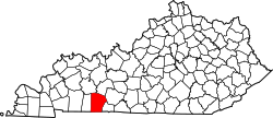
Schochoh, Kentucky

Last updated

Schochoh, Kentucky
USA Kentucky location map.svg
Red pog.svg
Schochoh
Usa edcp location map.svg
Red pog.svg
Schochoh
Coordinates: 36°43′22″N86°47′28″W / 36.72278°N 86.79111°W / 36.72278; -86.79111
Country United States
State Kentucky
County Logan
Elevation
636 ft (194 m)
Time zone UTC-6 (Central (CST))
  Summer (DST) UTC-5 (CDT)
GNIS feature ID503046 [1]

Schochoh is an unincorporated community in Logan County, Kentucky, United States.

History

The community, which is named for a location in Judea, was used as a camp meeting site during the Second Great Awakening before its first permanent buildings were built in the 1850s. It grew from its religious origins into a small farming community noted for its corn. [2] The community holds an annual Christmas parade, which began in 1990. [3] [4]

References

  1. "Schochoh". Geographic Names Information System . United States Geological Survey, United States Department of the Interior.
  2. "Schochoh". The News-Democrat and Leader. September 18, 1975. pp. 46–47. Retrieved November 19, 2020 via Newspapers.com.
  3. Griffin, Mark (2006). Logan County. Arcadia Publishing. p. 42. ISBN   9780738543697.
  4. Cooper, Chris (December 3, 2019). "Schochoh Christmas is a warm and friendly affair". The News-Democrat and Leader. Retrieved November 19, 2020.