
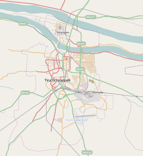
Tiruchirappalli, also called Tiruchi or Trichy, is a major tier II city in the Indian state of Tamil Nadu and the administrative headquarters of Tiruchirappalli district. It is the fourth largest city as well as the fourth largest urban agglomeration in the state. Located 322 kilometres (200 mi) south of Chennai and 374 kilometres (232 mi) north of Kanyakumari, Tiruchirappalli sits almost at the geographic centre of the state. The Cauvery Delta begins 16 kilometres (9.9 mi) west of the city where the Kaveri river splits into two, forming the island of Srirangam, which is now incorporated into the Tiruchirappalli City Municipal Corporation. The city occupies an area of 167.23 square kilometres (64.57 sq mi) and had a population of 916,857 in 2011.

Srirangam is a neighbourhood of the city of Tiruchirappalli, Tamil Nadu, India. A river island, Srirangam is bounded by the Kaveri on one side and its distributary Kollidam on the other side. Considered as the first among the 108 Divya Desams, Srirangam is home to a significant population of Sri Vaishnavites.

Bharathidasan University (BDU) is a university in the city of Tiruchirapalli, Tamil Nadu, India. It is located on Tiruchirappalli-Pudukkottai National Highway 336. It has affiliated colleges in the districts of Karur, Nagapattinam, Perambalur, Pudukkottai, district, Tiruvarur and Tiruchirapalli. It is a recognised university, supported by the University Grants Commission of India. All major faculties of science and arts are represented

Tiruchirappalli District is located along the Kaveri River in Tamil Nadu, India. The main town in Tiruchirappalli District is the city of Tiruchirappalli, also known as Trichy. During the British Raj, Tiruchirappalli was known as Trichinopoly, and was a district of the Madras Presidency; it was renamed upon India's declaration of independence in 1947. As of 2011, the district had a population of 2,722,290 with 1,013 females for every 1,000 males.
Thiruverumbur is a neighbourhood in the city of Tiruchirapalli in the Indian state of Tamil Nadu. It was merged with the Tiruchirappalli Corporation in 2011.

Thuraiyur is a town and a municipality in the Tiruchirappalli district in the Indian state of Tamil Nadu. It was upgraded to a III Grade Municipality from Town Panchayat on 17 January 1970, and to a II Grade Municipality in May 1998. It was upgraded to Selection Grade Municipality in the year 2008. It is also a taluka. Thuraiyur(Sub district)is the main town of Tiruchirappalli district. Thuraiyur town is expected to become Thuraiyur district with the addition of a new railway track. Thuraiyur is at the center of Tamil Nadu, connected to many main cities. It is located 310 km away from Chennai.In Trichy district biggest municipality is Thuraiyur and nowadays here 1lakh peoples are living but here water issues, ward rearrangement, city development plans not yet done by Thuraiyur Municipality Corporation.
Thillai Nagar is the poshest locality in Tiruchirappalli in the Indian state of Tamil Nadu. It is a prominent commercial and residential locality in Trichy. Being the most busiest area in Trichy city, it has a daily floating population of 5 lakhs. The locality is also a home to many of the city's VIPs and government officials. The area has all the top branded showrooms in the city. Also with a well planned urban infrastructure in place, surrounded by trees and its connectivity with all modern amenities such as schools, parks, banks, recreation centres, hospitals, hotels, temples, restaurants, shopping centres, police station, bus stops and Trichy Fort Railway station etc. makes the locality an elite residential place.

Tiruchirappalli Junction railway station (TPJ) is a junction station in Tiruchirappalli, Tamil Nadu. It serves as the headquarters for Tiruchirappalli railway division of the Southern Railway Zone. The station code is TPJ, used for official purposes. Daily approximately 1,50,000 passengers are using this Tiruchirappalli Junction. TPJ is the only railway station in southern railway to host Diesel-electric Multiple Unit (DEMU) shed. Tiruchirappalli Junction is the second largest railway station in Tamil Nadu and one of the busiest railway station in India.

The Tiruchirappalli City Municipal Corporation is the municipal corporation which looks after the city administration of Tiruchirappalli in Tamil Nadu, India. It consists of a legislative and an executive body. The legislative body is headed by the city mayor while the executive body is headed by a Chief Commissioner.
K. K. Nagar or Kalaignar Karunanidhi Nagar is a residential part of Tiruchirappalli City in Tamil Nadu, India. The K.K. Nagar neighbourhood is near the Tiruchirappalli International Airport, and is the most densely populated ward in the city and also the most populous ward in the city of Tiruchirapalli. It is a part of T.C.C since 1994.

The Indian Institute of Management Tiruchirappalli is a public graduate business school located on Tiruchirappalli-Pudukkottai National Highway 336, Tamil Nadu, India. Founded in 2011, it is one of the seven Indian Institutes of Management the Indian government had set up during the Eleventh Five-Year Plan and was mentored by IIM Bangalore. It was the 11th IIM to be set up in India. Classes for the first batch began on 15 June 2011.

Tiruchirappalli has a well-developed transport infrastructure. Being located almost at the geographic centre of the state Tamil Nadu India, Trichy is well connected by Road, Rail and Air with most cities.

Trichy Engineering College (TEC) is a College of Engineering located in Konalai, a village on the Tiruchirappalli to Chennai national highway, in Tamil Nadu, India. It was established in 1998. It is affiliated with Anna University. As of January 2011 it offers five undergraduate courses. This one of the two colleges in trichy which has department of Mechatronics. TEC was founded by Annai Santhiya Educational Health & Charitable Trust, Woraiyur, Tiruchirappalli with the permission of the Government of Tamil Nadu. The Trust, which is dedicated to the cause of promoting technical education as part of its philanthropic scheme, purchased 41.7 acres of land in Konalai Village and established the College.
Mannarpuram is a part of the city of Tiruchirappalli in Tamil Nadu, India. The headquarters of the Trichy division of the Tamil Nadu Electricity Board (TNEB) are located here. The Trichy Cricket Association's Mannarpuram Coaching Academy, one of the city's important coaching academies is also located here.
Edamalaipatti Pudur or E.Pudur is a residential part and one of very large part and the extension part of the city of Tiruchirappalli in Tamil Nadu, India. Surrounded by KK Nagar to East, Karumandapam to West, Crawford to North & Panjapur to South. E.Pudur has Self amenities like Hospitals, Pazhamudircholai, Tailorings, Flour Mills, School and Petrol Bunk.
Pirattiyur is a part of the city of Tiruchirappalli and located in Tiruchirappalli West taluk, Tiruchirappalli district, Tamil Nadu, India. A former Town Panchayat, which covers the whole of Edamalaipatti Pudur, it was merged with the Tiruchirappalli Corporation in 1994.
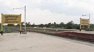
Pudukkottai railway station is a railway station located in Pudukkottai town, serving the people of Pudukkottai District in Tamil Nadu. It falls under the operational limits of Madurai Railway Division of the Southern Railway Zone. It is a major as well as an important passing station present on the Tiruchirappalli- Karaikkudi railway line. It is under the station category B.
Panjapur is an area of Tiruchirappalli suburbs of Edamalaipatti Pudur of Trichy in Tamil Nadu, India. It comes under the city limit with Tiruchirappalli city corporation and Tiruchirappalli West taluk. Ward 39 of Trichy corporation covers Panjapur.
National Highway 336 is a National Highway which runs for 52 km completely in the state of Tamil Nadu, India. It is part of the old National Highway 210. The Road splits off from NH-36 at junction on the outskirts of Pudukkottai till Trichy where Keeranur being major town in-between. Many important places exists along the route like Bharathidasan University, Anna University Trichy, Indian Institute of Management Tiruchirappalli, and Trichy Airport.
