
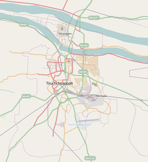
Tiruchirappalli, also called Tiruchi or Trichy, is a major tier II city in the Indian state of Tamil Nadu and the administrative headquarters of Tiruchirappalli district. The city is credited with being the best livable city and the cleanest city of Tamil Nadu, also fifth most safest city for women in India. It is the fourth largest city as well as the fourth largest urban agglomeration in the state. Located 322 kilometres (200 mi) south of Chennai and 374 kilometres (232 mi) north of Kanyakumari, Tiruchirappalli sits almost at the geographic centre of the state. The Cauvery Delta begins 16 kilometres (9.9 mi) west of the city where the Kaveri river splits into two, forming the island of Srirangam which is now incorporated into the Tiruchirappalli City Municipal Corporation. The city occupies an area of 167.23 square kilometres (64.57 sq mi) and had a population of 916,857 in 2011.

Perambalur is one of the 38 districts in the state of Tamil Nadu, India. The district headquarters is located at Perambalur. The district occupies an area of 1,752 km² and had a population of 565,223 with a sex-ratio of 1,003 females for every 1,000 males in 2011.

Musiri is a Panchayat town in the Tiruchirappalli district in the Indian state of Tamil Nadu. It has an average elevation of 82 metres (269 feet).
Pappakurichi is a census town in Tiruchirappalli district in the Indian state of Tamil Nadu. It was merged with the Tiruchirappalli Corporation in 2011.
Thiruverumbur is a neighbourhood in the city of Tiruchirapalli in the Indian state of Tamil Nadu. It was merged with the Tiruchirappalli Corporation in 2011.

Thuraiyur is a town and a municipality in the Tiruchirappalli district in the Indian state of Tamil Nadu. It was upgraded to a III Grade Municipality from Town Panchayat on 17 January 1970, and to a II Grade Municipality in May 1998. It was upgraded to Selection Grade Municipality in the year 2008. It is also a taluka. Thuraiyur(Sub district)is the main town and most reputed town in Tiruchirappalli district. Thuraiyur town is expected to become Thuraiyur district with the addition of a new railway track. Thuraiyur is at the center of Tamil Nadu, well connected to many main cities. It is located 310 km away from Chennai.In Trichy district biggest municipality is Thuraiyur and nowadays here 1 lakh peoples are living but here water issues, ward rearrangement, city development plans not yet done by Thuraiyur Municipality Corporation.

Ariyalur is a town and district headquarters of Ariyalur district in the South Indian state of Tamil Nadu and rich limestone and surrounded with seven cement factories and two sugar factories. The town is located at a distance of 310 km (190 mi) from the state capital Chennai.

The Tiruchirappalli City Municipal Corporation is the municipal corporation which looks after the city administration of Tiruchirappalli in Tamil Nadu, India. It consists of a legislative and an executive body. The legislative body is headed by the city mayor while the executive body is headed by a Chief Commissioner.

Tiruchirappalli (Tamil: தி௫ச்சிராப்பள்ளி pronunciation , also called Tiruchi or Trichy, is a city in the Indian state of Tamil Nadu and the administrative headquarters of Tiruchirapalli District. It is the fourth largest municipal corporation in Tamil Nadu and also the fourth largest urban agglomeration in the state. It is located almost at the geographic centre of the state.
T. Indragandhi is an Indian politician and was a member of the 14th Tamil Nadu Legislative Assembly from the Thuraiyur constituency, which is reserved for candidates from the Scheduled Castes. She represented the All India Anna Dravida Munnetra Kazhagam party.
Thiruverumbur taluk is a taluk of Tiruchirappalli district of the Indian state of Tamil Nadu. The headquarters is the town of Thiruverumbur.Corporation wards 61 to 65 takes place. This taluk consist of 30 revenue villages.
Alathur is a village in Tiruchirappalli taluk of Tiruchirappalli district, Tamil Nadu. It was merged with the Tiruchirappalli Corporation in 2011.
Ellakudy is a village in Tiruchirappalli taluk of Tiruchirappalli district, Tamil Nadu, India. It was merged with the Tiruchirappalli Corporation in 2011.
Natarajapuram is a village in Tiruchirappalli taluk of Tiruchirappalli district in Tamil Nadu, India.
Sooriyur is a village in Tiruchirappalli taluk of Tiruchirappalli district in Tamil Nadu, India.
Thiruppattur (Tirupattur) is a small village in Manachanallur Taluka, Tiruchirappalli district, Tamil Nadu, India. It is 33 km by road north of the city of Tiruchirappalli on the NH-45, the Chennai - Tiruchi highway. It is 18.5 km by road north of the village of Samayapuram, and 15 km by road southwest of Padalur (East).
Tiruchirappalli is a city in the Indian state of Tamil Nadu. It is the fourth most populous city and is the densest regional urban area in the state. According to the 2001 census, Tiruchirappalli had a population of 752,066 with in the city limits and an extended urban agglomeration population of 866,354. According to the 2011 provisional population totals, the city has a population of 846,915 while the regional urban area has 1,021,717 residents. The city's sex ratio of 1025 is among the best for any city in India which has a population of one million or more.
Tiruchirappalli East Taluk is a taluk in the Tiruchirapalli district in the Indian state of Tamil Nadu. It was formed in 2013 when the Tiruchirappalli taluk was bifurcated into Tiruchirappalli East and Tiruchirappalli West. Wards 7 to 38 and 43 of the Tiruchirappalli Municipal Corporation come under the East Taluk. This taluk covers most parts of Tiruchirappalli East constituency and has a separate regional transport office at Sanjeevi Nagar at Devadhanam.
Kalpalayam is a village located in the Manachanallur taluk of the Tiruchirappalli district of the Indian state Tamil Nadu. It is situated 3 km away from taluk headquarter Manachanallur and 15 km away from district headquarter Tiruchirappalli.