Serra de Paüls

Last updated
Serra de Paüls

PuntadelAliga4.JPG

Montsagre de Paüls
Highest point
Peak Punta de l'Aigua
Elevation 1,091.6 m (3,581 ft)
Coordinates 40°56′52.8″N0°23′15.5″E / 40.948000°N 0.387639°E / 40.948000; 0.387639 Coordinates: 40°56′52.8″N0°23′15.5″E / 40.948000°N 0.387639°E / 40.948000; 0.387639
Geography
Catalonia location map.svg
Red triangle with thick white border.svg
Serra de Paüls
Location in Catalonia
Location Terra Alta and Baix Ebre
Parent range Ports de Tortosa-Beseit
Geology
Orogeny Alpine orogeny
Type of rock Limestone
Climbing
Easiest route Drive from Paüls or Prat de Comte

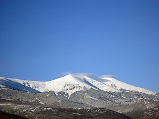
Serra de Paüls is a mountain range in the northern side of the Ports de Tortosa-Beseit, Catalonia, Spain. The highest summit, Punta de l'Aigua has an elevation of 1,091.6 metres above sea level. [1]

Ports de Tortosa-Beseit mountain

Ports de Tortosa-Beseit, also known as Ports de Beseit, or simply as Els Ports[əls ˈpɔɾts] or Lo Port[lu ˈpɔɾt] by locals, is a limestone mountain massif located at the north-eastern end of the Sistema Ibérico, a complex system of mountain ranges and massifs in the centre of the Iberian Peninsula. Its highest point is Mont Caro, 1,441 m. Rivers such as the Matarranya and the Sénia have their source in these mountains.

Catalonia Autonomous area of northeastern Spain

Catalonia is an autonomous community in Spain on the northeastern corner of the Iberian Peninsula, designated as a nationality by its Statute of Autonomy. Catalonia consists of four provinces: Barcelona, Girona, Lleida, and Tarragona. The capital and largest city is Barcelona, the second-most populated municipality in Spain and the core of the sixth most populous urban area in the European Union. It comprises most of the territory of the former Principality of Catalonia. It is bordered by France (Occitanie) and Andorra to the north, the Mediterranean Sea to the east, and the Spanish autonomous communities of Aragon to the west and Valencia to the south. The official languages are Catalan, Spanish, and the Aranese dialect of Occitan.

Spain Kingdom in Southwest Europe

Spain, officially the Kingdom of Spain, is a country mostly located on the Iberian Peninsula in Europe. Its territory also includes two archipelagoes: the Canary Islands off the coast of Africa, and the Balearic Islands in the Mediterranean Sea. The African enclaves of Ceuta and Melilla make Spain the only European country to have a physical border with an African country (Morocco). Several small islands in the Alboran Sea are also part of Spanish territory. The country's mainland is bordered to the south and east by the Mediterranean Sea except for a small land boundary with Gibraltar; to the north and northeast by France, Andorra, and the Bay of Biscay; and to the west and northwest by Portugal and the Atlantic Ocean.

Contents

Geography

The central part of the range is known as Montsagre de Paüls.

This range is named after the town of Paüls, located on its SE side. Together with neighboring and parallel Serra de l'Espina the Serra de Paüls is within the geological area that connects the Ports de Tortosa-Beseit mountain massif with the Catalan Pre-Coastal Range. [2]

Paüls Municipality in Catalonia, Spain

Paüls is a municipality in the comarca of Baix Ebre, province of Tarragona, Catalonia, Spain.

Serra de lEspina mountain in Spain

Serra de l'Espina is a limestone mountain chain located at the north-eastern end of the Iberian System. It connects the Ports de Tortosa-Beseit mountain massif with the Catalan Pre-Coastal Range.

Catalan Pre-Coastal Range system of mountain ranges running parallel to the Mediterranean Sea coast in Catalonia

The Catalan Pre-Coastal Range is a system of mountain ranges running parallel to the Mediterranean Sea coast in Catalonia. It is part of the Catalan Mediterranean System. Its main axis runs between the Catalan Transversal Range and the Serra de l'Espina, which connects with the Ports de Tortosa-Beseit, part of the Iberian System. The highest point is 1.706,7 m at the Montseny Massif.

See also

Sistema Ibérico mountain range

The Iberian System, is one of the major systems of mountain ranges in Spain. It consists of a vast and complex area of mostly relatively high and rugged mountain chains and massifs located in the central region of the Iberian Peninsula, but reaching almost the Mediterranean coast in the Valencian Country in the east.

Related Research Articles

Tortosa Municipality in Catalonia, Spain

Tortosa is the capital of the comarca of Baix Ebre, in Catalonia, Spain.

Beceite municipality in Aragon, Spain

Beceite or Beseit is a municipality located in the Matarraña/Matarranya comarca, province of Teruel, Aragon, Spain. According to the 2004 census (INE), the municipality has a population of 603 inhabitants. It is part of the Taula del Sénia free association of municipalities.

Mont Caro mountain

Mont Caro or Caro is the highest mountain of the Ports de Tortosa-Beseit, Catalonia, Spain.

Tossal dels Tres Reis mountain in Spain

Tossal dels Tres Reis or Tossal del Rei is a mountain of the Ports de Tortosa-Beseit massif, Spain. It has an elevation of 1,350 metres above sea level.

Tossal den Cervera mountain in Spain

Tossal d'en Cervera or Pic de Cervera is a mountain in Spain. It is located between the municipal terms of La Sénia, in the Montsià comarca, and La Pobla de Benifassà, Baix Maestrat, Valencian Community.

La Moleta (Alfara de Carles) mountain in Spain

La Moleta or Moleta d'Alfara is a mountain of the Serra de l'Espina, a northern prolongation of the Ports de Tortosa-Beseit, Catalonia, Spain. It has an elevation of 812 metres above sea level. La Moleta rises about 5 km NNW above the village of Alfara de Carles. It is readily identifiable from afar, for its striking squarish shape contrasts sharply with the other summits of the mountain chain.

Tinença de Benifassà historical comarca of the Valencian Community, Spain

Tinença de Benifassà is a historical comarca of the Valencian Community, Spain. It is nowadays part of the Baix Maestrat, one of the present-day Comarques of the Valencian Community, even though commercial and human relationships have been stronger with Els Ports in the west, the Terres de l'Ebre in the northeast and the Matarranya in the northwest in historical times.

Mas de Barberans Municipality in Catalonia, Spain

Mas de Barberans is a municipality in the comarca of Montsià in Catalonia, Spain. It is part of the Taula del Sénia free association of municipalities.

Muntanya de Santa Bàrbara mountain in Spain

Muntanya de Santa Bàrbara is a mountain that is part of the northwestern foothills of the Ports de Tortosa-Beseit, Catalonia, Spain. It has an elevation of 751.3 metres above sea level.

Arnes, Terra Alta Municipality in Catalonia, Spain

Arnes is a municipality in the comarca of la Terra Alta in Catalonia, Spain.

Serra de Pàndols mountain in Spain

Serra de Pàndols is a limestone mountain chain located at the southern end of the Catalan Pre-Coastal Range, in Catalonia, Spain.

Serra de Cavalls mountain in Spain

Serra de Cavalls is a mountain chain located at the southern end of the Catalan Pre-Coastal Range, Catalonia, Spain. The ridge's highest point is Punta Redona. This mountain range lies within the Benissanet, Gandesa and El Pinell de Brai municipal term. On the northern side are two ridges of parallel foothills called Serra del Pebre and Serra de Santa Madrona. Its northern prolongation is known as Serra de la Vall de la Torre.

Roques de Benet mountain in Spain

Roques de Benet is a compact group of sheer rocky outcrops in the northwestern side of the Ports de Tortosa-Beseit, Catalonia, Spain. The highest summit has an elevation of 1,017.1 metres above sea level.

Penyagalera mountain in Spain

Penyagalera is a rocky mountain in the northern side of the Ports de Tortosa-Beseit, Aragon, Spain. Punta de Penyagalera, the highest summit, has an altitude of 1,034.4 metres above sea level.

Cardó Massif

The Cardó Massif, also known as Cardó-Boix Massif, is a mountain massif in the Baix Ebre comarca, in Catalonia, Spain. This massif is composed of a number of mountain ranges located on the left side of the Ebro river near Tortosa. The massive calcareous cliffs of the Serra de Cardó form the eastern side of the spectacular gorges through which the Ebro River winds its way in the final stage of its course, separating the Ebro Valley from the Mediterranean coastal area.

Roquetes, Tarragona Municipality in Catalonia, Spain

Roquetes is a municipality in the comarca of Baix Ebre, in the province of Tarragona, in Catalonia, Spain. According to the 2013 census, the municipality has a population of 8,297 inhabitants.

Castell de lAirosa mountain in Spain

Castell de l'Airosa is a rocky mountain in the eastern side of the Ports de Tortosa-Beseit, Catalonia, Spain. Its summit has an altitude of 953.8 metres above sea level.

References

  1. "Mapa Topogràfic de Catalunya". Institut Cartogràfic de Catalunya. Retrieved 9 September 2010..
  2. Ports de Beseit