Sierra de Santa Cruz, Aragon

Last updated
Sierra de Santa Cruz

Orcajo 08.jpg

Sierra de Santa Cruz near Orcajo
Highest point
Peak Cerro de Santa Cruz
Elevation 1,423 m (4,669 ft)
Listing List of mountains in Aragon
Coordinates 41°06′15″N01°33′55″W / 41.10417°N 1.56528°W / 41.10417; -1.56528 Coordinates: 41°06′15″N01°33′55″W / 41.10417°N 1.56528°W / 41.10417; -1.56528
Geography
Relief Map of Spain.png
Red triangle with thick white border.svg
Sierra de Santa Cruz
Location in Spain
Location Campo de Daroca (Aragon)
Parent range Iberian System
Geology
Orogeny Alpine orogeny
Climbing
First ascent Unknown
Easiest route Drive from Orcajo or Cubel

Sierra de Santa Cruz is a mountain range in the Campo de Daroca comarca, Aragon, Spain. It is located north of the Laguna de Gallocanta.

Campo de Daroca Comarca in Aragon, Spain

Campo de Daroca is one of the comarcas of Aragon, in the Province of Zaragoza, Aragon, Spain. It is located in the mountainous Iberian System area.

Aragon Autonomous community of Spain

Aragon is an autonomous community in Spain, coextensive with the medieval Kingdom of Aragon. Located in northeastern Spain, the Aragonese autonomous community comprises three provinces : Huesca, Zaragoza, and Teruel. Its capital is Zaragoza. The current Statute of Autonomy declares Aragon a historic nationality of Spain.

Spain Kingdom in Southwest Europe

Spain, officially the Kingdom of Spain, is a country mostly located on the Iberian Peninsula in Europe. Its territory also includes two archipelagoes: the Canary Islands off the coast of Africa, and the Balearic Islands in the Mediterranean Sea. The African enclaves of Ceuta and Melilla make Spain the only European country to have a physical border with an African country (Morocco). Several small islands in the Alboran Sea are also part of Spanish territory. The country's mainland is bordered to the south and east by the Mediterranean Sea except for a small land boundary with Gibraltar; to the north and northeast by France, Andorra, and the Bay of Biscay; and to the west and northwest by Portugal and the Atlantic Ocean.

Contents

Geography

The ridge is aligned in a NW-SE direction. Its highest point is Cerro de Santa Cruz (1,423 m). The Ermita de Santa Cruz shrine is located in the range. [1]

This mountain chain rises west of Daroca and stretches through the municipal terms of Balconchán, Atea, Orcajo, Cubel, Valdehorna, [2] Val de San Martín and Santed.

Daroca Municipality in Aragon, Spain

Daroca is a city and municipality in the province of Zaragoza, Aragon, Spain, situated to the south of the city of Zaragoza. It is the center of a judicial district.

Balconchán is a municipality located in the province of Zaragoza, Aragon, Spain. According to the 2004 census (INE), the municipality has a population of 18 inhabitants.

Atea is a deity in several Polynesian cultures, including the Marquesas and Tuamotu Islands, and New Zealand.

Ecology

The plant Centaurea pinnata is an endangered species present in this mountain range. [3]

Endangered species Species of organisms facing a very high risk of extinction

An endangered species is a species which has been categorized as very likely to become extinct. Endangered (EN), as categorized by the International Union for Conservation of Nature (IUCN) Red List, is the second most severe conservation status for wild populations in the IUCN's schema after Critically Endangered (CR).

See also

Related Research Articles

Comarcas of Spain

In Spain traditionally and historically, some autonomous communities are also divided into comarcas.

Atea is a municipality in the province of Zaragoza, Aragon, Spain. It is part of the comarca of Campo de Daroca.

Peracense Place in Aragon, Spain

Peracense is a town in the province of Teruel, Aragon, on the north-east of Spain. It is located 51 kilometres from Teruel, the capital province.

Villahermosa del Campo municipality in Aragon, Spain

Villahermosa del Campo is a municipality located at the feet of the Sierra de Cucalón, in the province of Teruel, Aragon, Spain. According to the 2004 census (INE), the municipality has a population of 97 inhabitants.

Badules municipality in Aragon, Spain

Badules is a municipality located in the province of Zaragoza, Aragon, Spain. According to the 2010 census the municipality has a population of 95 inhabitants.

Mainar is a municipality located in the province of Zaragoza, Aragon, Spain. According to the 2004 census (INE), the municipality has a population of 162 inhabitants.

Villadoz Place in Aragon, Spain

Villadoz is a municipality located in the province of Zaragoza, Aragon, Spain. According to the 2010 census, the municipality has a population of 83 inhabitants.

Romanos, Aragon Municipality in Aragón, Spain

Romanos is a small municipality in Campo de Daroca, in Aragón. It was an important town during the War of the Two Peters, and has many historic sites, such as castles and churches, some of which are part of the 156 monuments that the Government of Aragon presented to UNESCO for the declaration of the sites as historic protected sites. They were confirmed as this in 2001 in the UNESCO meeting in Helsinki.

Laguna de Gallocanta lake in Spain

The Gallocanta Lake is an endorheic lake in Aragon, Spain. Falling within the boundaries of two provinces, Teruel and Zaragoza, the lake is located just to the south of Gallocanta village, between the Aragonese comarcas of Campo de Daroca and Comarca del Jiloca. This lake is situated on a high continental plain at an altitude of almost 1,000 m.

Santa Eulalia del Campo Place in Aragon, Spain

Santa Eulalia del Campo is a municipality located in the province of Teruel, Aragon, Spain. According to the 2005 census (INE), the municipality has a population of 1,171 inhabitants.

Cerro Colorado Mountains

The Cerro Colorado Mountains are a low mountain range in southern Pima County, Arizona, USA. The highest point of the range is. The range consists of a NNW–SSE trending ridge with several shorter ridges extending off the main ridge to the ENE. The higher portions of the range cover an area of about 21 km2 (8.1 sq mi), with dimensions of 6.8 km (4.2 mi) by 4.0 km (2.5 mi).

Sistema Ibérico mountain range

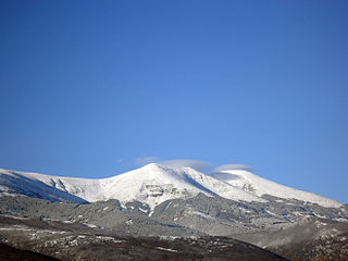
The Iberian System, is one of the major systems of mountain ranges in Spain. It consists of a vast and complex area of mostly relatively high and rugged mountain chains and massifs located in the central region of the Iberian Peninsula, but reaching almost the Mediterranean coast in the Valencian Country in the east.

Jiloca (river) river in Aragón, Spain

The Jiloca is a river in Aragón, Spain, a tributary of the river Jalón, and part of the watershed of the Ebro basin. The course of the river runs through the provinces of Teruel and Zaragoza. It has a length of 126 kilometres (78 mi) and an average flow rate of 2.1 cubic metres per second (74 cu ft/s), although this varies between the seasons. The river flows in a generally north easterly direction from its source near Monreal del Campo.

Used is a municipality in province of Zaragoza, Aragon, Spain. According to the 2010 census (INE), the municipality has a population of 328 inhabitants.

Jiloca (comarca) Comarca in Aragon, Spain

Jiloca Comarca is a comarca in Aragon, Spain. It is located in Teruel Province, in the mountainous Iberian System area.

Sierra de Javalambre mountain in Spain

Sierra de Javalambre is a 29 km (18 mi) long mountain range in the Gúdar-Javalambre comarca of Aragon and the Rincón de Ademuz and Serrans comarcas of the Valencian Community, Spain.

Sierra de Santa Cruz may refer to:

Sierra de Vicort mountain in Spain

Sierra de Vicort, also known as Sierra de Vicor, is a 20 km (12 mi) long mountain range in the Comunidad de Calatayud and Campo de Daroca comarcas of Aragon, Spain.

Lechón, Aragon municipality in Aragon, Spain

Lechón is a municipality located in the province of Zaragoza, Aragon, Spain. According to the 2010 census, the municipality has a population of 57 inhabitants. Its postal code is 50369.

References